Download
1 / 8
80 likes | 219 Vues
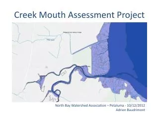
Creek Mouth Assessment Project. North Bay Watershed Association – Petaluma - 10/12/2012 Adrien Baudrimont. Project Background. San Francisco Estuary Partnership. Watershed Program. Implement SFEP Comprehensive Conservation Management Plan. Support community-based watershed stewardship.

E N D
Creek Mouth Assessment Project North Bay Watershed Association – Petaluma - 10/12/2012 AdrienBaudrimont
Project Background San Francisco Estuary Partnership Watershed Program Implement SFEPComprehensive Conservation Management Plan Support community-based watershed stewardship Assess and compare watershed health Increase resiliency with regard to climate change Increase local government capacity
Project Pyramid Identify Creek Mouth Restoration Opportunities Creek Mouth general assessment based on existing information Excel table with information on creek mouths (Tool1) GIS Dataset focused on creek mouths (Tool2) Tools Qualitative & quantitative information gathering (SFEP + Partners) GIS Data (SFEI) Method
Collecting Data about Creek Mouths To the first Upstream Barrier From the Opening to the Bay Creek Mouth • Bridge • Culvert • Major tributary Creek Mouth Table (Tool1) How to represent this data? County & Creek Mouth Level
County level Creek Mouth Query Length of the creek mouth, width at the mouth Invasive Plants Presence of Steelhead Local stakeholders Contamination/trash Public land Private land
Creek Mouth level Creek Mouth Query Public land Private land Ownership Restoration Projects Levees Data Historical Ecology
Today Pilot Project: Marin County 10 Creeks, from Coyote Creek to Novato Creek Building of the method, how much details do we need, what indicators. First step to test the project, then all around the Bay, ± 85 creeks One year project Phase 2: Online Tool