Download
1 / 29
290 likes | 418 Vues
Fault displacement from Landsat 8 pre- and post -earthquake image differencing and initial field observations of the surface rupture of the M W 7.7 Awaran earthquake of 24 September 2013.

E N D
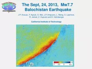
Fault displacement from Landsat 8 pre- andpost-earthquake image differencing andinitial field observations of the surface rupture of theMW7.7 Awaran earthquake of 24 September 2013 Kenneth W. Hudnut (1), Shuhab D. Khan (2), Francois Ayoub (3), Sinan Akciz (4), Din M. Kakar (5), MohibUllah Baloch (5), Muhammad Shafeh (5), Abdul S. Khan (6) 1) U.S. Geological Survey, 525 S. Wilson Ave., Pasadena, California 2) Univ. of Houston, Houston, Texas 3) Tectonics Observatory, Department of Geological and Planetary Sciences, California Institute of Technology, Pasadena, California 4) Univ. of California, Los Angeles 5) Dept. of Geology, University of Balochistan 6) Center of Excellence in Mineralogy, University of Balochistan Southwestern Pakistan M 7.7 Earthquake of 24 Sept. 2013 24 February 2014 AmericaView Meeting USGS HeadquartersReston, Virginia
SW Pakistan; Awaran, Balochistan MW 7.7 Earthquake of 24 Sept. 2013 Damage in Awaran >30 villages damaged; >800 fatalities; >20,000 houses collapsed
Part 1. Landsat 8 results (COSI-Corr)Part 2. Surface Faulting – field dataPart 3. Worldview 2 rupture mapping
Part 1. Landsat 8 results (COSI-Corr)Part 2. Surface Faulting – field dataPart 3. Worldview 2 rupture mapping
Landsat 8 COSI-Corr Results Landsat 8 185 km wide swath, nearly perfect timing and location & high quality geometry of sensor; very nice synoptic overview of rupture. USGS makes all data openly available. Initial ‘raw’ N-S difference image from COSI-Corr with v. minor adjustments (georegist’n is excellent) Courtesy of Francois Ayoub (Caltech)
Landsat 8 COSI-Corr Results Courtesy of Francois Ayoub (Caltech)
Landsat 8 COSI-Corr Results slip distribution curve, based on F. Ayoub’s COSI-Corr v.2 results SW NE slip (meters) epicenter - bi-lateral, with most energetic rupture (big slip) towards the SW - not a 45° dipping fault, nearly pure lateral slip, & indication of very large slip (from imagery) distance from SW end (kilometers)
Part 1. Landsat 8 results (COSI-Corr)Part 2. Surface Faulting – field dataPart 3. Worldview 2 rupture mapping
field photos and observations Dandar localities
Part 1. Landsat 8 results (COSI-Corr)Part 2. Surface Faulting – field dataPart 3. Worldview 2 rupture mapping
Summary:Part 1. Landsat 8 results (COSI-Corr) Part 2. Surface Faulting – field data Part 3. Worldview 2 rupture mappingFault slip along-strike variation Fault dip along-strike variation Slickensides, striations, source physicsFuture Work: field work in the north and more detailed work on entire surface rupture to document event
Questions? Pakistan - U.S. Science and Technology Cooperation Program Special thanks to USAID and Prof. Abdul S. Khan and his students of the University of Balochistan: Din M. Kakar MohibUllah Baloch Muhammad Shafeh Ken Hudnut hudnut@usgs.gov (626)672-6295