Download
1 / 34
360 likes | 525 Vues
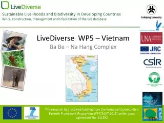
Ba Be – Na Hang GIS Database. Do Minh Phuong & Nguyen Thanh Xuan National Institute of Agricultural Planning and Projection, Vietnam LiveDiverse South Africa meeting 13 - 23 March 2010. Contents. Task 5.4: GIS Database Study area LD GIS Database Components

E N D
Ba Be – Na Hang GIS Database Do Minh Phuong & Nguyen Thanh Xuan National Institute of Agricultural Planning and Projection, Vietnam LiveDiverse South Africa meeting 13- 23 March 2010
Contents • Task 5.4: GIS Database • Study area • LD GIS Database Components • Database functions and targets • GIS Database Design • LD WP-5 Data Inventory
Task 5.4 – GIS Database • Construction, management and facilitation of the GIS database with combined spatial information on ecological, socio-economic and cultural-spiritual vulnerability.
Study area • Ba Be National Park (22°21' – 22°29'N, 105°34' – 105°42'E) • Na Hang Nature Reserve (22°16’-22°31’N, 105°22’-105°29’E)
LD GIS Database Components Socio Economic Bio-physical Cultural/spiritual
Database functions Display information in different media; Search for information; Edit, update or delete information; Analyze spatial data; Exchange information from one to other systems; Summarize and report data; Eliminate errors.
Targets Level: Not too difficult. Format: Popular (GIS, remote sensing and database). Functions: GIS vector, raster; Satellite image; GPS capability; Multimedia. Special issue: Capable of managing spatial data from different zones in one view.
Database design • Database model • Database format • Software • Other issues
Database model: File Geodatabase Storage: various GIS files in folders. User access: Single or small no. of users at the same time. Format: ESRI file format. Size limit: 1 Gb for each file. Platform: Cross-platform. Security: OS security.
Database format Vector: ESRI Shapefile (Shp, Shx). Database: DBF (IV, VI, FoxPro). Raster: ESRI raster. Satellite image: Geo-TIFF, JPG, BMP...
Software Recommended: ESRI ArcGIS 9x
Other issues Character code. Map projection. Geographic unit. Naming convention. Database version.
Vietnam GIS data inventory • Administrative • Topography • Satellite image • Ecological • Other data
General information Data format: ESRI Shape file (SHP), dBASE IV database (DBF) Projection: Universal Transverse Mercator (UTM) Datum: WGS-84 Zone: 48 North Unit: Degree (Lat/Long)
Administrative data Province boundary. District boundary. Commune boundary. Resident area. Point of interest: people committee, clinic station, school, hamlet names.
Topography data Elevation contour, spot height. River system. Transport system. Digital elevation model (DEM).
Thematic maps Landuse map. Soil map. Climate map. Forest types.
Geological data Earthquake data
Satellite images Landsat TM 1994. Landsat TM 2000. ASTER 2001. SPOT-5 2008.
Ecological data Distribution of Rhinopithecus avunculus Distribution of Gorsachius magnificus Distribution of Leptolalax nahangensis Distribution of Paramesotriton deloustali Distribution of Rana bacboensis Distribution of Asplenium colaniae Distribution of Gastrochilus minutiflorus Distribution of Liparis conopea Distribution of Paphiopedilum helenae ….
Some fieldtrip photos Ba Be - Na Hang trip, 21-24 July, 2009 Ba Be - Na Hang trip, 03-12 Nov, 2009
WP-5 Vietnam Team Thank you very much for your attentions! www.livediverse.eu
LiveDiverse Vietnam Study Area 2 1 1 Ba Be 2 Na Hang
LiveDiverse Vietnam Study Area 1 2 1 Ba Be 2 Na Hang
Topography data Topography Points of interest Road network River system
Thematic maps Soil types Landuse 2005 Forest types Climate map
Satellite data Landsat 1994 Landsat 2000 ASTER 2001 SPOT-5 2008
Ecological data Distribution of Asplenium colaniae
Fieldtrip photos (21-25 Jul., 2009) Visitors can take a tour around by ferryboat Ba Be lake, a natural attraction Some are in nice-looking location Some houses built right inside the protected area
Fieldtrip photos (21-25 Jul., 2009) Waste disposal from tourism Firework within Ba Be lake This man’s daily activity is mesh-fishing
Fieldtrip photos (21-25 Jul., 2009) These two men are fishing near Fairy Cave A new swimming pool in the core area of Ba Be LiveDiverse meeting in Ba Be LiveDiverse team’s discussion with local authorities
Fieldtrip photos (21-25 Jul., 2009) Fishing at Gam River, Na Hang A beautiful view from Cock Pass in Na Hang New vegetation cover by national reforestation projects A Hydro-power dam in Na Hang
Fieldtrip photos (03-12 Nov., 2009) Meeting with Ba Be People committee Touring Ba Be lake Visiting Chan village, Dong Phuc, Ba Be Visiting Bo Lu village, Nam Mau, Ba Be
Fieldtrip photos (03-12 Nov., 2009) Visiting Thanh Tuong Commune, Tuyen Quang Meeting with Tuyen Quang People committee Meeting with Na Hang Forest Protection Dep. Visiting Ban Da village, Son Phu, Tuyen Quang