Download
1 / 16
160 likes | 366 Vues
Intro to Freely Available Viz Tools. Google Earth http://code.google.com/apis/earth NPS Xj3D-Earth http://x3d-earth.nps.edu/ Virtual Terrain Project http://www.vterrain.org/Doc/ OSSIM http://www.ossim.org/ http://www.ossim.org/OSSIM/Albums/Pages/OMAR_1.html

E N D
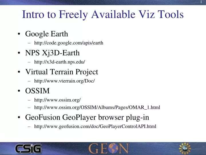
Intro to Freely Available Viz Tools • Google Earth • http://code.google.com/apis/earth • NPS Xj3D-Earth • http://x3d-earth.nps.edu/ • Virtual Terrain Project • http://www.vterrain.org/Doc/ • OSSIM • http://www.ossim.org/ • http://www.ossim.org/OSSIM/Albums/Pages/OMAR_1.html • GeoFusion GeoPlayer browser plug-in • http://www.geofusion.com/doc/GeoPlayerControlAPI.html
Google Earth Vector Data LDM GRIB grib_contour GDAL/OGR KML • UCAR LDM Pipeline Weather Service • Iraq SIGACT DB Viewer Raster Data LDM NDIS libndis decoder GDAL HFA PostGIS TileIndex UMN WMS PostGIS DB Perl CGI KML
Data Volume Summary for atmos.ucsd.edu Maximum hourly volume 8042.904 M bytes/hour Average hourly volume 3552.075 M bytes/hour Average products per hour 150669 prods/hour Feed Average Maximum Products (M byte/hour) (M byte/hour) number/hour CONDUIT 1782.324 [ 50.177%] 4790.116 49533.091 NGRID 675.413 [ 19.015%] 1071.433 15790.318 NNEXRAD 382.068 [ 10.756%] 464.990 32828.114 HDS 231.230 [ 6.510%] 442.280 19543.568 FNMOC 201.222 [ 5.665%] 1276.871 2070.591 NIMAGE 161.138 [ 4.536%] 256.017 202.523 FNEXRAD 85.628 [ 2.411%] 110.465 54.614 IDS|DDPLUS 33.052 [ 0.930%] 39.052 30646.614 • ATMOS.UCSD.EDU Stats • http://www.unidata.ucar.edu/cgi-bin/rtstats/rtstats_summary_volume?atmos.ucsd.edu
ATMOS.UCSD.EDU Stats • http://www.unidata.ucar.edu/cgi-bin/rtstats/rtstats_summary_volume?atmos.ucsd.edu+GRAPH
Iraq SIGACTDB Query • SIGACT report emails • Load into PostGIS • Perl CGI Web interface • KML output
Iraq SIGACTDB Result • SQL Select statement shown for advanced users • KMZ Launch Link
Iraq SIGACT DB Result KMZ Time Series Animations
Virtual Terrain Project • Convergence of the fields of CAD, GIS, visual simulation, surveying and remote sensing. • Elevation • Artificial Terrain Generation • Ground Detail • Imagery • groundcover • Culture • Roads • Fences • Power poles • Vehicles and Traffic • Buildings • Plants • Virtual Forestry
OssimPlanet • Remote Collaboration • Double Precision 3D Accuracy • Native File Access • OGC WMS Interfaces • WorldWind Server Support • KML/KMZ Support • Path Recording • Open Source Software • Video Wall, Multiprojector • Multi-Platform Support
Ossim OMAR • OSSIM Mapping Archive • Searchable • Temporal • Geospatial • Metadata • Openlayers Tilecache • WMS output • KML output
GeoPlayer Web Browser Plug-in • HTML defined UI • JavaScript • Flash • Direct DB Access • PostGIS • MySQL • … • 3D Wavefront .obj • Animation Paths • Image Billboards • Environment Access • Screen • Object smer
John Graham San Diego State University Visualization Center Chief Scientist OSGeo Charter member johng@telascience.org