Download
1 / 16
160 likes | 339 Vues
Vision for ground aerosol networks: AERONET and MPLNET. Operational Status Science Results Future Plans Issues ??. Brent Holben and Judd Welton. AERONET Status. Provide a long term data set to: Characterize aerosol optical properties Validate Satellite & model aerosol retrievals

E N D
Vision for ground aerosol networks: AERONET and MPLNET • Operational Status • Science Results • Future Plans • Issues • ?? Brent Holben and Judd Welton
AERONET Status • Provide a long term data set to: • Characterize aerosol optical properties • Validate Satellite & model aerosol retrievals • Synergism with Satellite obs., climate change • ~280 instruments • ~150-180 Operational sites • Network Partners • GSFC • Photons (France) • RIMA (Spain) • CSIRO (Australia) • AEROCAN (Canada) • Expansion to Asia, Africa high latitudes and over water sites
AERONET Version 2 AOD • Version 2 (AOD) implemented July 2005 • Improved corrections: Satellite • TOMS (Monthly gridded O3) • SCIAMACY (Monthly gridded NO2) • Improved corrections: NCEP/NCAR Reanalysis • Dynamic Air Pressure for Rayleigh, CO2 and CH4 correction • Much improved and QA water vapor retrievals • Details: http://AERONET.gsfc.nasa.gov/version2-table.pdf
AERONET Inversion 2 • Unified Inversion products from combined Sphere/Spheroid models • Uncertainty Assessment w/ all products • Dynamic surface reflectances • MODIS & IGBP Ecosystem reflectance (16 day product) + generic BRDF • Cox-Munk for ocean sites (hybrid for coastal sites) • Snow and Ice from NISE product (daily) • Inversion Products for PP retrievals • Forcing computations
AERONET Science • Aerosol Characterization • Algorithm Development • AOD • Retrievals • Validation • Synergism • Blue Sky • Cockamamy • Significant Enabling: • ‘AERONET Paper’- 493 • citations since 1998, • 134 citations in 2005 • Staff citations of key • AERONET papers since • 2000: 751
AERONET-OC(Ocean Color) • SeaPRISM (cimel) • Normalized water leaving radiances (Lwn) • 3 yr validation w/ in water optics (Venice) • Standard AOT and inversion products • (nm): 412, 443, 490, 531, 551, 677, 870, 940, 1020
AERONET-MSP(multispectral polarization) • Spectral linear Polarization hourly • Standard Products • L(nm): 340, 380, 440, 500, 675, 870, 940, 1020, 1640 • AERONET testing (Feb. to May 2006) • Operational products: June 2006 Dual filter wheel, top for polarizers bottom for IAD filters
AERONET support for Field Campaigns • East AIRE-east China • Base Asia-Thailand • Milagro-Mexico • AMMA-W. Africa • ABC-damn near everywhere • ARM sites • RAJO-MEGHA: Indo-Gangenic Plain (2007) • Seven Seas-S. Asia and SE Asia (2007?)
AERONET Directions • Collaboration and co-location w/ BSRN and MPLNET (extinction profile product) • Development of SolRad-Net (http://solrad-net.gsfc.nasa.gov) • Cloud Optical depth retrievals • 2008-new Sun-Sky system to be phased in • 2008-CO2 network (±3ppm accuracy anticipated) • BAMGOMAS browser: Links to MODIS, MPLNET, Gocart, backtrajectories for all AERONET sites
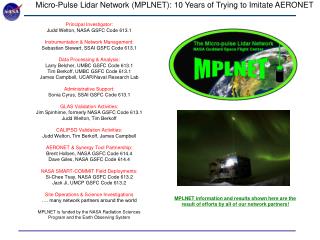
former experiment, permanent site planned former experiment, permanent site proposed * line denotes research cruise active no longer active planned proposed Overview and Current Status Objective: Acquire long-term observations of the vertical structure of aerosols and clouds using common instrumentation and data processing in a federated network. Focus on co-location with select AERONET sites. Currently: 11 active sites 7 planned sites (in preparation) 4 proposed sites (funding dependent) 10 sites no longer active (mostly field campaigns*) 1 Ocean cruise (two cruises pre-dating MPLNET are available) * Most campaigns utilize SMART-COMMIT platform (Tsay et al. 613.2) Goddard team + 11 Partners compose MPLNET: NASA LaRC NOAA ESRL Naval Research Lab - Monterey Japan’s National Institute of Polar Research Spain’s Instituto Nacional de Técnica Aeroespacial - INTA 3 US Universities 2 Korean Universities 1 Taiwan University other partners pending
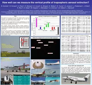
Example Comparisons from study (25 Days total). Also surveyed past 7 field campaigns of such work. MPLNET MPL ARM Neph/PSAP AATS Summary of Study Results: MPLNET among best performers Altitude (km) Altitude (km) Conclusion: state-of-the-art techniques remain 15 - 20% uncertain MPLNET meets or exceeds that target range Extinction 1/km AOT Recent Publication/Science Results How well do state-of-the-art techniques measuring the vertical profile of tropospheric aerosol extinction compare? B. Schmid, R. Ferrare, C. Flynn, R. Elleman, D. Covert, A. Strawa, E. Welton, D. Turner, H. Jonsson, J. Redemann, J. Eilers, K. Ricci, A. G. Hallar, M. Clayton, J. Michalsky, A. Smirnov, B. Holben, and J. Barnard, J. Geophys. Res., 111, D05S07, doi:10.1029/2005JD005837, 2006. • Aerosol Extinction & Optical Depth profiles compared in most comprehensive study to date: • MPLNET (column AOT anchored to AERONET) • MPL from ARM • Airborne Ames Sunphotometer (AATS) • Airborne nephelometer & absorption photometer • Airborne cavity ring-down system (Cadenza) • Ground-based Raman lidar (CARL) • AATS used as truth • AATS is most direct measure of AOT profile • AATS Column AOT within 2% of AERONET AATS-14 shown above
Cloud-Aerosol Lidar and Infrared Pathfinder Satellite Observations Future Plans, Network Growth, & News African Monsoon Multidisciplinary Analysis Our future long term site in Senegal will also support the AMMA campaign, but is not dependent upon NAMMA funding (US). Our NASA MOU with Ecole Supérieure Polytechnique in Dakar is near completion. In addition, our current long term site in the Canary Islands will support AMMA, and a proposed SMART-COMMIT site on Cape Verde may also participate. • MPLNET is a part of the established CALISPO cal/val plan, and we are gearing up for validation activities after launch. • Direct validation of layer heights, extinction, AOT • Statistical seasonal studies • Look Up Table development: aerosol extinction-to-backscatter ratio New Generation MPL: Type 4B Available from Sigma Space Corp. South Pole MPLNET Site: 1999-2006 • MPL and MPLNET recently won Tech Transfer award from Federal Laboratory Consortium • MPLNET team currently working with Sigma to incorporate athermal telescope for improved instrument stability in field MPLNET will contribute to International Polar Year activities
AOD: 0.714 + 0.01 C: 180 + 9 Sa: 64 + 4 sr Altitude (km) Aerosol Extinction 1/km Data Retrieval: Aerosol Extinction Profile MPLNET: Combined Active Lidar and Passive Photometer Continuous MPLNET lidar observations PBL structure & evolution readily apparent Retrieved Aerosol Extinction Profile AERONET column Aerosol Optical Depth (AOD) observation used as constraint to retrieve vertical profile of aerosol extinction from the MPL Aerosol extinction-to-backscatter ratio is calculated, this parameter is required for satellite retrieval of extinction