Download
1 / 20
200 likes | 204 Vues
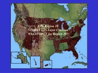
The EPA Region 3 GIS Team provides cartographic support and spatial analysis for environmental scientists studying a wide range of issues in Delaware, Maryland, Virginia, West Virginia, Pennsylvania, and the District of Columbia. They also support freshwater biology studies and maintain databases for EPA regulated facilities, superfund sites, and other geospatial data.

E N D
US EPA Region 3 GIS Team Presented by: Douglas Ross, GIS Analyst & Carmen Constantine, GIS Team Leader of General Dynamics Network Systems, US EPA Contactor
US EPA Mission Statement “The EPA Region 3 GIS Team provides high-quality cartographic support along with spatial display and query applications in support of the region’s environmental scientists studying a wide range of problems and issues. EPA Region 3 consists of the states of DE, MD, VA, WV, PA, and the District of Columbia.” In addition, the Wheeling Field Office supports EPA’s geospatial efforts in Appalachia by providing GIS support to the Freshwater Biology Team on issues including Mountaintop Mining/Valley Fill Studies.
Major Area of Mountaintop Mining Before After
Freshwater Biology Team • Identifies watersheds and sites for national stream assessment methods development Regional Methods Initiatives (RMIs): • EMAP Quantitative Excess Sediment Index • Headwater Intermittent Streams Study • Quantified headwater stream lengths to respond to proposed rule changes of the Clean Water Act definition of “waters of the United States”
US EPA Geospatial Data Stewardship EPA Region 3 serves as a supplementary data steward for point locations of EPA Regulated Facilities (e.g. CERCLA, RCRA, TRI, NPDES) and the National Hydrography Dataset (NHD). The Wheeling Field Office Freshwater Biology also maintains macro-invertebrate and fisheries databases that are shared among state agencies within EPA Region 3.
Superfund Sites (CERCLIS) and RCRA Superfund Sites: • Comprehensive Environmental Response, Compensation, and Liability Information System (CERCLIS) • Uncontrolled or abandoned hazardous waste locations • NPL – National Priority List RCRA Sites: • Resource Conservation and Recovery Act • Inventory and management system of hazardous waste handlers
TRI and NPDES Sites TRI Sites: • TRI – Toxic Release Inventory • Information on toxic chemical releases and other waste management activities • Publicly available database NPDES Sites: • NPDES – National Pollution Discharge & Elimination System • Permits are issues to discharge waste water into water bodies • Regulated by the Clean Water Act
How can the statewide geospatial community participate in or benefitfrom our mapping efforts?
EPA Region 3 welcomes dialogs with all West Virginia GIS programs to foster efficient and timely data exchange, interstate and interregional cooperation, and to better understand the environmental problems and issues that are unique to West Virginia.
Top 3 Geospatial Accomplishments of 2003 • GIS and mapping support for the Monongahela River Basin Mine Pool Project • Stony River Watershed Mapping for the Mount Storm 316(a) Project • Development and GIS/mapping support of geospatial databases of fisheries, macro-invertebrate, and other samples collected by the Wheeling Field Office Freshwater Biology Team
Monongahela River Basin Mine Pool Project Mapping Issue: Water (Acid Mine Drainage) from coal mines is projected to discharge into the Monongahela River Basin. GIS Support: Identify affected streams, Locate surface features, Create regional maps. (A Multi-Agency Project)
Stony River Watershed MappingMt Storm 316(a) Project Issue: Thermal discharges from the Mt. Storm Power Station are being monitored by Dominion Energy and EPA for effects to the aquatic life. GIS Support: • Created maps of monitoring stations for the field team • Created stream network from DEM • Created and measured selected watersheds • Collected GPS locations
Stony River Watershed MappingMt Storm 316(a) Project Stony River and Mud Run Locations: • Watersheds were created and measured for each site location • GPS coordinates were recorded • Fish and Macro-invertebrate samples were collected • Databases were created and queried
Top 3 Geospatial Goals for 2004 • GIS support of the Headwater Intermittent Streams Study (HISS) at Cooper’s Rock State Forest • Continued analysis and GIS support of fisheries data in the Monongahela River Basin • Cooperation with EPA Region 5 (Chicago) in support of environmental studies in the Ohio River Basin
Headwater Intermittent Streams Study GIS Support: • Selecting streams and measuring the watershed area • Map Creation • GPS field work • Develop geospatial databases from field samples * Watersheds derived using ESRI’s ArcGIS Hydro Model and Tools
GIS Support of Fisheries Data in the Monongahela River Basin USEPA, WVDEP, PADEP, and others will continue the assessment of fisheries and aquatic resources in the Monongahela River and tributaries. Continued GIS support of the fisheries data, and continued mapping support of Monongahela River and tributaries.
GIS Support of Ohio River Basin Studies • Locate the intakes, discharges, and tributaries along the Ohio River • Develop a geospatial database to identify the source of spills or leaks and address homeland security issues
Further Resources: EPA Home Page: www.epa.gov ESRI’s ArcGIS Hydro Model: www.support.esri.com Monongahela River Basin Mine Pool Project: www.wvwri.nrcce.wvu.edu/programs/mbmpp/index.cfm