Download
1 / 28
280 likes | 404 Vues
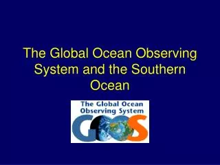
GEOSS support for IPCC assessments - The GCOS Assessment Cycle - 1 -4 February 2011, WMO, Geneva, Switzerland Dr Carolin Richter, Director, Global Climate Observing System Secretariat. SPACE BASED. In-Situ. The Composition and Scope of the Main Global Observing Systems. GEOSS. WIGOS.

E N D
GEOSS support for IPCC assessments- The GCOS Assessment Cycle - 1 -4 February 2011, WMO, Geneva, SwitzerlandDr Carolin Richter, Director, Global Climate Observing System Secretariat
SPACE BASED In-Situ The Composition and Scope of the Main Global Observing Systems GEOSS WIGOS GTOS GOOS GCOS (GOS AND GAW)
The goal of the Global Climate Observing System (GCOS) is to provide comprehensive information on the total climate system, involving a multidisciplinary range of physical, chemical and biological properties and atmospheric, oceanic, hydrologic, cryospheric and terrestrial processes. (Annex A to 1992 and 1998 WMO-IOC-UNEP-ICSU MOU)
The Emergence of Human-Induced Climate Change as a Global Science and Policy Issue UNCHE 1972 WCC-1 1979 WCC-2 1990 WCC-3 2009 First World Climate Conference Second / Third World Climate Conference Science UN Conference on the Human Environment World Commission on Environment and Development UNGA 1961 WCED 1987 UNFCCC 1992 Copen- hagen 2009 Policy Computers United Nations General Assembly World Climate Programme UN Framework Convention on Climate Change WCP 1979 IPCC 1988 Assessment Space Intergovernmental Panel on Climate Change GARP 1967 WCRP Research Global Atmospheric Research Programme World Climate Research Programme Observation WWW 1967 GCOS 1991 World Weather Watch Global Climate Observing System
Adaptation Mitigation Climate- sensitive Sectors UNFCCC Interface Prediction & Information IPCC World Climate Research Programme (WCRP) Global Climate Observing System (GCOS) GCOS as building block for a Global Framework for Climate Services
The GCOS Mission Observations made in the past have unequivocally demonstrated that the climate system is warming. Climate observation must be enhanced and continued into the future to enable users to: • Detect further climate change and determine its causes • Model and predict the climate system • Assess impacts of climate variability and change • Monitor the effectiveness of policies for mitigating climate change • Support adaptation to climate change • Develop climate information services • Promote sustainable national economic development • Meet other requirements of the United Nations Framework Convention on Climate Change (UNFCCC) and other international conventions and agreements
Continuous Improvement and Assessment Cycle GCOS – an all domain system
What needs to be measured ? GCOS Essential Climate Variables (ECVs) Global observations feasible (practical, cost-effective) High impact on needs of UNFCCC, climate research (WCRP), climate change assessments (IPCC) • Priority list of variables to be observed systematically • Initiated in 1995 in The GCOS Plan, then called «principal observations» • Submitted first time 1998 in 1st Adequacy Report to the UNFCCC, Buenos Aires • Global observations feasible (practical, cost-effective) • High impact on needs of UNFCCC, climate change assessments (IPCC) • Term « ECV » promoted in 2003, 2nd Adequacy Report to the UNFCCC
What needs to be measured ? GCOS Essential Climate Variables (ECVs) • Atmospheric • Surface – Air temperature, Precipitation, Pressure, Surface radiation budget, Wind speed and direction, Water vapour • Upper Air – Earth radiation budget (including solar irradiance), Temperature, Wind speed and direction, Water vapour, Cloud properties • Composition –Carbon dioxide, Methane and other long-lived greenhouse gases (N2O, CFCs, HCFCs, HFCs, SF6 and PFCs), Ozone and Aerosol, supported by their precursors (NO2, SO2, HCHO and CO). • Oceanic • Surface – Sea-surface temperature, Sea-surface salinity, Sea level, Sea state, Sea ice, Surface Current, Ocean colour, Carbon dioxide partial pressure, Ocean acidity, Phytoplankton. • Sub-surface:Temperature, Salinity, Current, Nutrients, Carbon dioxide partial pressure, Ocean acidity, Oxygen, Tracers. • Terrestrial • River discharge, Water use, Ground water, Lakes, Snow cover, Glaciers and ice caps, Ice sheets, Permafrost and seasonally-frozen ground, Albedo, Land cover (including vegetation type), Fraction of absorbed photosynthetically active radiation (FAPAR), Leaf area index (LAI), Above ground biomass, Soil carbon, Fire disturbance, Soil moisture. Blue/bold = largely space-based red = new in 2010 plan
What needs to be measured ? How to do it ? Implementation Plan up-date in August 2010
What needs to be measured ? How to do it ? Satellite Supplement up-date in January 2011 Climate Monitoring PrinciplesGuidelines for Datasets and Products • In-situ data supplement to the Implementation Plan needed.
Workshop to look at gaps in observations and at gaps in basic science, Sydney, Australia, October 2007 Workshop on Space based Architecture for Climatein January 2011 • ERB • Precip • Watervapour
By whom / by which means ? • “network owners”, i.e., • National Meteorological Services • National Hydrological Services • Research organizations • Space agencies • Marine / coastal agencies… How to improve the system ? • Promote the actions in the GCOS Implementation Plan • Operating a cooperation mechanism • Develop Regional Action Plans • Advocating national coordination
Where are we now ? Where can you get your data ? www.GOSIC.org (acts as data access service) ECV WIKIs (GCOS Secretariat, ESA CCI, GOSIC)
Where are we now ? Progress Report 2004-2008Progress Report 2009-2013 (?) Report on the Adequacy of the GCOS, 1998Second Report on the Adequacy of the GCOS, 2003Third Report on the Adequacy, (?) 2013-2015
Where are we now ? Report on the Adequacy of the GCOS, 1998Second Report on the Adequacy of the GCOS, 2003Implementation Plan 2004 and up-date in 2010Progress Report 2004-2008 in support of the UNFCCC GCOS findings support and contribute also to IPCC, WCRP and Global Framework for Climate Services Observations for adaptation and impacts
Where are we now ? Demonstrate the socio-economic values of ECVs How good is the information which is available to you ?Is there any information missing ?What is needed to provide you with adequate information ?
Agriculture and Farming Fisheries Forestry Soil Water regime, coastal and marine protection Biological diversity / Ecosystems Health Infrastructure, Transport, Urban Settlements, Building Tourism industry Energy industry Trade and industry Financial services industry Socio-economic values of climate predictions and projections 2050 and beyond = Climate Change (Emission Scenarios) Strategic thinking about future trends and scenarios Set a future trend Climate change Decadal 10 yrs Inter-Decadal (10-20 yrs) Multi-Decadal (> 20 yrs) (PDO,AMO,MOC) Look ahead& Make plans > 20 yrs Long-term planning for implementing policies Seasonal, Inter-annual (ENSO, TBO, Monsoon) 6 months – 5 yrs Management of quality and quantity; Protective and regulatory measures Choose & decide later 6 months – 5 years Sub-seasonal Intra-Seasonal MJO (30-90 days) up to 6 months Logistics: scheduling of activities 1 - 6 months Act now
Mapping societal sectors into domain based ECVs Surface: Air temperature Wind speed/direction Water vapour, Pressure, Precipitation, Surface radiation budget Upper-air: Temperature, Wind speed/direction Water vapour Cloud properties Earth radiation budget Composition: Carbon dioxide, Methane (other GHGs) Ozone and Aerosol River discharge Water use Ground water Lakes Snow cover Glaciers and ice caps Ice sheets Permafrost Albedo Land cover(inc.veg type) FAPAR, Leaf area index (LAI), Above-ground biomass, Soil carbon Fire disturbance Soil moisture Surface: Sea-surface temperature Sea-surface salinity Sea level Sea state Sea ice Surface current Ocean colour Carbon dioxide part.p. Ocean acidity Sub-surface: Temperature Salinity Current Nutrients Carbon dioxide part p. Ocean acidity Oxygen Tracers Phytoplankton Agriculture and Farming Water regime, coastal and marine protection Infrastructure, Transport, Urban Settlements, Building Soil Fisheries Health Financial services industry Atmospheric Observations Forestry Biological diversity / Ecosystems Energy industry Trade and industry Tourism industry Agriculture and Farming Water regime, coastal and marine protection Health Energy industry Infrastructure, Transport, Urban Settlements, Building Forestry Water regime, coastal and marine protection Financial services industry Agriculture and Farming Soil Terrestrial Observations Tourism industry Trade and industry Biological diversity / Ecosystems Health Tourism industry Energy industry Trade and industry Water regime, coastal and marine protection Fisheries Infrastructure, Transport, Urban Settlements, Building Health Oceanic Observations Financial services industry Biological diversity / Ecosystems
Up-dated Implementation Plan:in brief: • new ECVs, now 50 (before 44 ) • reflection on ecosystems (biodiversity) • additional focus on reference and super site networks (measurements of several ECVs at one site for a more comprehensive understanding of the ecosystem) • cost estimation (additional costs and costs for existing systems)
GCOS Progress Report 2004-2008 - Summary • Developed Countries: • improved climate observation capabilities, • limited progress in resolving financial issues related to long-term continuity • Developing Countries: • limited (in-situ) progress, with decline in some regions, • capacity building support remains small in relation to needs • Satellite agencies: • improved mission continuity and capability • increasingly meeting climate needs • Progress made, but: • Many gaps persist, • Continued engagement needed for coordinated implementation and long-term continuity Summary of progress on all 131 Actions in 2004 GCOS IP
2. Satellite Supplement – up-date in January 2011 Update 2006 Satellite Supplement to the GCOS IP (GCOS-107) • Update detailed GCOS requirements for FCDRs and ECV products in terms of • accuracy, • stability, • temporal/spatial resolution, • calibration and validation needs and opportunities, • relevant international working groups. for Atmosphere, Ocean, Land and Cross-Cutting actions. • Expert Meeting, January 10 – 12, 2011, Geneva improvements on most of the ECVs, extra sections, e.g., GHGs, precursors, « pressure » emerges now also as space-based observed ECV. • Open for public review, March 2011 • Finalising draft, 2nd Qrt 2011.
Ensuring Quality and Acceptance of ECV Datasets (GCOS Guideline for generation of ECV datasets and products, May 2010) When generating climate datasets and ECV products, particular attention to: • Responds to increasing demand by producers to ensure climate quality / meeting GCOS requirements • Ensure transparency (“Say what you do”)
Value of Observations (ECVs) for societal sectors Agriculture and Farming Fisheries Forestry Soil Water regime, coastal and marine protection Biological diversity / Ecosystems Health Infrastructure, Transport, Urban Settlements, Building Tourism industry Energy industry Trade and industry Financial services industry Strategic Thinking on how to adapt the relevant policies 2050 and beyond = Climate Change (Emission Scenarios) Land use Reproductivity capacity of stocks Compositions& conversion;use of timber Water reserves Coastal lines Shipping ways Adaption of species; migration; extinction Construction & Planning policies Purchasing&stock policies Innovations in technology Financial policies Long-term Planning Protect&conservehabitats; Design Landscapes Design plants to withstand extreme weather Decadal 10 yrs Inter-Decadal (10-20 yrs) Mulit-Decadal (> 20 yrs) (PDO,AMO,MOC) Protection of human settlement and infrastructure Timber yields Regional shifts Risk assessment; new business strategies Crop Industry, breeding Plan to restock fish, &fishing methods Drinking water quality, protection of coastal lines&waterways Adapt to of standards for buildings/infrastructure; Investigate into new routes. Foster research; Connect to sector of infrastructure (green spaces, air corridors in cities..), Crisis precautions; Renewable energy; Alternative energy sources Sustained soil quality Revise framework conditions; new/modify business modles Management Generation of energy; New/modify regulations Seasonal, Inter-annual (ENSO, TBO, Monsoon) 6 months – 5 yrs Develop vaccines; Implement bio-monitoring systems Crop type&sequence Stocking rates Herd management Health of forest Timber harvest Drinking&cooling water; Possibility of shipping Revision of standards for buildings/infrastructure; Make provisions to repair roads and railways. Provision of labour& infrastructure Take precautions by plant safety managers; new legal regulations Change Fishing area&method Humus formation Carbon sequestration Reduce pollutants and nutrients (initiate legislation) Logistics: scheduling of activties Sub-seasonal Intra-Seasonal MJO (30-90 days) up to 6 months Lead of adequate personnel&material (resources) Choose Fishing area&method Harvesting/Planting; Prevention of fire Drought, Pest outbreaks Prevention on floods, droughts, storm surges Prevention of accidents, injuries or allergies, heat stress, circulation disorders…. Prevention of accidents and damages Travel management Planting/Harvesting Use of Pesticides/Fertiliser Lead of adequate energy supply Prevention of mud slides, erosion synoptic
From Observations to Information to ServicesExample of a societal sector: Agriculture and Farming Example output parameter: Climate Observations (annual means, monthly means) ECV Air temperature Model for Agrometeorology Number of days of ice, frost, summer, heat, tropical days, tropical nights ECV Precipitation Start of vegetation period Start of flowering of winter rape Ripeness of maize Vernalization (low temp. stimulus) Model data; phenological & meteorological observations Planting date Sowing date Yield changes Research