Download
1 / 50
500 likes | 507 Vues
Interpreting Ancient Tectonic Settings. Historical Geology. 2014. Introduction. Ancient tectonic settings – cratons and mobile belts Craton – the stable, tectonically inactive portion of a continental interior Mobile belts – the tectonically active portions of the continents. Craton.

E N D
Interpreting Ancient Tectonic Settings Historical Geology 2014
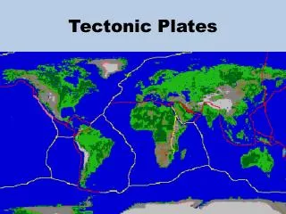
Introduction • Ancient tectonic settings – cratons and mobile belts • Craton – the stable, tectonically inactive portion of a continental interior • Mobile belts – the tectonically active portions of the continents
Ancient Mobile Belts • Very ancient tectonically active regions: • Mountains eroded • Valleys filled with sediment • Ocean basins subducted • Or…. Accreted to continents
Mobile Belts / Pangaea • Mobile belts – the tectonically active portions of the continents
Craton • Part of craton where Precambrian rock is exposed – the shield • Part of craton where Precambrian rock is covered with sediment – the platform • Sedimentary rocks of the platform – the cratonic sequences
Part of craton where Precambrian rock is exposed – the shield Geologic Regions Shields
Ancient Continent-continent divergent • Rifting • Creates grabens (valleys) bounded by normal faults • Results in 3 “Arms” or rift valleys • Two usually open to ocean basins • One stays a continental rift (failed rift) • A failed rift is called an aulacogen • May result in large river basins
Triple Junction Aulacogen Continental rifts are commonly initiated by hot spots. The continental crust begins to extend, creating a rift valley (graben) bounded by normal faults. Typically, continental rifts will have three “arms” or three rift valleys that meet at one point (a triple junction), forming a shape like a “Y”.
Ancient ocean-ocean divergent • Rift valley may sink below sea level • Results in surge in volcanism • Creating basaltic oceanic crust between two fragments of continental crust • Fragments of oceanic crust now on land are ophiolites
Ancient Subduction Zones • Occurs only at ocean-ocean convergent and ocean-continent convergent • Ocean crust recycles back into the mantle • Along the trench sediments are dragged down and metamorphosed • Resulting rock is high-temp blue schist • Chaotic mixture of ig and sed rocks from both crusts is a melange
Ancient Subduction Zones • Eventually, a microcontinent (or another large continent) will be rafted along the subduction zone • Continent-continent collision will occur • Pieces of one continent accreted to another continent are called accreted terranes
Accreted Terrane Accreted terranes will lead to an increase in continent size. Much of North America has formed from continental accretion.
Ancient Subduction Zones • Oceanic plate subducts under another plate • May be extension behind volcanic arc • This forms a back arc basin • Modern example: Sea of Japan • Subduction continues = back arc basin closes • Compression results in formation of fold and thrust mountains inland from volcanic arc
Ancient Continent-Continent Collision • When two continents collide – subduction ceases • As continents collide - crust will be folded and thrusted from compressional stress • Large complex mountain belts develop • Geologists use adjacent sediment (clastic wedge) to estimate elevation of ancient mountain belts
Wilson Cycle • The Wilson cycle is the cycle of opening and closing ocean basins. • Initial stages = a hotspot underneath a continent causes rifting • Example of this stage of cycle – East Africa Rift or Rio Grande Rift in New Mexico • If rifting continues, a new ocean basin and mid-ocean ridge will form • Example - Red Sea and Gulf of California • By the mature stage of rifting, a wide ocean basin will form • Example – Atlantic Ocean
Evidence of the Wilson Cycle in Canada’s Northwest Territories – Cross section onbottom, depicts a zone of intrusive igneous rocks that pass eastward into meta- morphic rocks and then into folded and thrust-faulted stratified rock.
Relationship of rock units following the Paleoproterozoic opening of an ocean basin along the western margin of the Slave province.
Assignment • Lab # 6 - Interpreting Ancient Tectonic Settings • Information – page 79 – 83 • Activity – page 85 - 90