Download
1 / 31
340 likes | 1.73k Vues
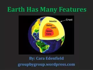
Geological Features of the Earth. Unit EQ: How do natural processes affect geologic features? Diane Gioia Bell’s Crossing Elementary. What are the geologic landforms on the continent?.

E N D
Geological Features of the Earth Unit EQ: How do natural processes affect geologic features? Diane Gioia Bell’s Crossing Elementary
What are the geologic landforms on the continent? When you think of landforms, you might think of mountains or valleys. These are continental landforms, or landforms on the continents. Landforms are also found under the ocean’s water. These are called oceanic landforms.
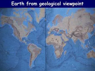
How do oceanic landforms compare to continental landforms? Discuss what you observe in this picture. The ocean floor has everything like land does: mountains, valleys, flat plains, and volcanoes. Which landforms can you pick out in this image?
Plains • Plains are large flat areas of land that are relatively low. A plain found in the ocean is called an abyssal plain. The Central United States has the Great Plains as shown below.
Mountains and Hills • A mountain has high elevations with steep sides and pointed tops. The top of the mountain is a peak, or summit. • A hill is similar to a mountain but it has a lower elevation. It is usually rounded but not as high as a mountain.
Valleys • Valleys are low, narrow areas on Earth’s crust. On land, valleys are usually formed by erosion. • Valleys in the ocean are called a rift zone, or rift valley. These are formed when the plate boundaries move apart from each other.
Canyon and Trenches • A canyon has steep, rocky walls and is usually formed by water erosion like the Grand Canyon. • Ocean trenches have a much lower elevation than the surrounding area and is caused by one plate sliding under another plate.
A volcano is a mountain that opens downward to a pool of molten rock below the surface of the earth. When pressure builds up, eruptions occur. Gases and rock shoot up through the opening and spill over or fill the air with lava fragments. Eruptions can cause lateral blasts, lava flows, hot ash flows, mudslides, avalanches, falling ash and floods. Volcano eruptions have been known to knock down entire forests. An erupting volcano can trigger tsunamis, flashfloods, earthquakes, mudflows and rockfalls. Mt. St. Helens Washington
Seamounts Volcanic cone shaped peaks that dot the ocean floor are called seamounts. Most are found in the Pacific Ocean. Most seamounts began life as volcanoes formed over hot spots in the ocean floor
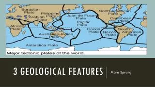
Canyon Valley Volcano Mountain range Low hills or plains Trench Rift Seamount Mid-ocean ridge Ocean basin and plains Continental vs. Oceanic Landforms
What are the landforms on the ocean floor? The amazing ocean floor is made up of three parts: the continental shelf the continental slope the deep blue sea
Continental Shelf The edges of the continents slope down from the shore into the ocean. The part of the continent located under the water is the continental shelf. In some places the shelf is fairly shallow and in other places it becomes very deep.
The steep slope where the continental shelf drops to the bottom of the ocean floor is called the continental slope. The depth of the water increases greatly here.
Mid-Ocean Ridge On the bottom of the ocean, there is a central ridge, or mountain range, that divides the ocean floor into two parts. These underwater volcanic mountains are the mid-ocean ridge. DID YOU KNOW? The Earth’s largest mountain range is underwater.
Mid-ocean ridge In which ocean is the mid-ocean ridge located?
Trenches The many steep-sided canyons and deep, narrow valleys in the bottom of the ocean are trenches. Ocean trenches are the deepest part of the ocean basin and are deeper than any valley found on land.
Did you Know? The Marianas Trench in the Pacific Ocean is the deepest trench in the world. It is nearly 7 miles (ll kilometers) below sea level. Mount Everest is only 5.5 miles (9 kilometers) above sea level.
The deep ocean basin, which is about 2.5 to 3.5 miles deep, covers 30 % of Earth's surface and has features, such as abyssal plains, deep-sea trenches and seamounts. • The abyssal plain is the flat, deep ocean floor. It is almost featureless because a thick layer of sediment covers the hills and valleys of the ocean floor below it.
Which landforms can you pick out now in this map of the ocean floor?
Quick Quiz • The ocean is a big, flat featureless plain. True or False false • The steep part where the continental shelf slopes down to the deepest part of the ocean is called the continental slope. True or False true
3. What are the deepest parts of the ocean called?a. Deep-sea trenchesb. Abyssal plainsc. Continentsd. Seamounts Deep sea trenches 4. What is a seamount? a. A scientist who studies the ocean floorb. Deep-sea trenchc. A fancy seagulld. A volcano that formed over a hot spot on the ocean floor. D
How can we classify and illustrate natural processes as constructive or destructive? Constructive – Processes that create landforms Destructive – Processes that destroy landforms
Natural Processes that can affect Earth’s oceans include: • Weathering – a term used to describe processes that break down rocks at or near the surface of the earth. Water is an important cause of weathering. Anything that causes rocks to wear down or break apart is a cause of weathering. • Erosion – the movement of sediments and soil by wind, water, and gravity
Deposition – the dropping, or depositing, of sediments by water, wind, or ice. Deposition builds up new land on Earth’s surface, like a delta at the end of a river or the pile up of a sand dune in a desert. Shells on the beach are deposition by ocean waves. • Landslides – mass movements of land due to gravity. Landslides can cause buildings to fall, or power and gas lines to break. Landslides even occur on the continental slope in the ocean.
Volcanic Eruptions – Volcanoes can change the Earth’s surface. When the magma erupts from the volcano, the top of the mountain can be changed. The lava and ash can destroy forests and bury fields. Eruptions can even change weather patterns. • Earthquakes – vibrations on the surface of the Earth caused by sudden movement in Earth, often along a fault line. Large earthquakes can cause landslides. Earthquakes under the ocean can cause huge waves, called tsunamis that destroy land and cause great damage on shore. • Floods – rapid erosion can take place and move soil and sediments away. When the flood recedes, new sediment is left behind and can build up rich soil deposits.
What are examples of ways natural processes can be both destructive and constructive?
Think you’ve seen coastal erosion? Check out this movie! http://whyfiles.org/091beach/images/house.mov
Optional Video Streaming Weathering 6:58 Giant Waves 4:17 Erosion 5:54 Earthquake 3:16 Deposition 1:18 Volcanoes 4:41
“What am I?” Riddle BookYou need to create a riddle book from your continental landform terms. You will create a book with a cover (your name needs to be in the top right hand corner), and a page for each term. Each page will have a riddle (one for each term), with the answer on the back of that page.
Oceanic Landform Picto-Cards You will create seven picto-cards, one for each oceanic landform listed on your matrix. On one side of the card you will draw a picture of the landform. On the flip side you will write the term and its definition, then your choice of an analogy or a sentence.