Download
1 / 31
310 likes | 419 Vues
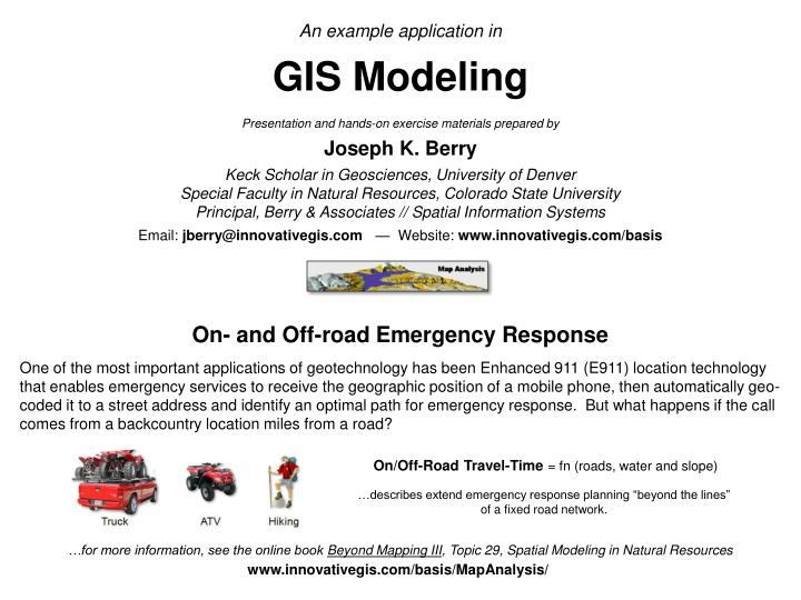
An example application in GIS Modeling Presentation and hands-on exercise materials prepared by Joseph K. Berry Keck Scholar in Geosciences, University of Denver Special Faculty in Natural Resources, Colorado State University Principal, Berry & Associates // Spatial Information Systems

E N D
An example application in GIS Modeling Presentation and hands-on exercise materials prepared by Joseph K. Berry Keck Scholar in Geosciences, University of Denver Special Faculty in Natural Resources, Colorado State University Principal, Berry & Associates // Spatial Information Systems Email: jberry@innovativegis.com — Website: www.innovativegis.com/basis On- and Off-road Emergency Response One of the most important applications of geotechnology has been Enhanced 911 (E911) location technology that enables emergency services to receive the geographic position of a mobile phone, then automatically geo-coded it to a street address and identify an optimal path for emergency response. But what happens if the call comes from a backcountry location miles from a road? On/Off-Road Travel-Time = fn (roads, water and slope) …describes extend emergency response planning “beyond the lines” of a fixed road network. …for more information, see the online book Beyond Mapping III, Topic 29, Spatial Modeling in Natural Resources www.innovativegis.com/basis/MapAnalysis/
On- and Off-road Emergency Response(Truck) The left side of the figure below illustrates the on-road portion of a travel-time (TT) surface from headquarters along secondary backcountry roads. The grid-based solution uses friction values for each grid cell in a manner analogous to road segment vectors in network analysis. The difference being that each grid cell is calibrated for the time it takes to cross it (0.10 minute in this simplified example). HQ(start) Emergency Response Surface …travel-time by truck from HQ along roads 26.5 minutes …farthest away by truck Roads Water Slope HQ(start) …each grid cell is calibrated by the time it takes to cross depending on the 1) type of movement and 2) the landscape conditions Off-Road
On- and Off-road Emergency Response(ATV) The figure below identifies the shortest combined on- and off-road ATV travel-times. Note that the emergency response solution forms a bowl-like surface with the headquarters as the lowest point and the road proximities forming “valleys” of quick access. The sides of the valleys indicate ATV off-road travel with steeper rises for areas of steeper terrain slopes; the grey areas indicate locations that are too steep for ATV travel. HQ(start) Emergency Response Surface …travel-time by truck from HQ along roads and then by ATV until too steep (>40% slope) 52.1 minutes …farthest away by truck and ATV Slopemap …draped over Elevation surface HQ(start) Too Steep Steep canyon area Too Steep For ATV use ATV use
On- and Off-road Emergency Response(Hiking) The figure below completes the total on- and off-road travel-timeto all locations by adding hiking time from where the wave front of the accumulated travel-time by truck and ATV stopped. Note the very steep rise in the surface (blue tones) resulting from the slow movement in the rugged and steep slopes of the canyon area. HQ(start) Farthest (end) HQ(start) Emergency Response Surface …travel-time by truck from HQ along roads, then by ATV until too steep and finally hiking in the steep terrain 96.0 minutes …farthest away by truck, ATV and hiking Response Surface …draped over Elevation surface HQ(start) Steep canyon area …accessing locations in the southern portions of the steep canyon require driving along the road, then proceeding via ATV and finally hiking nearly 45 minutes to the bottom of the canyon Optimal Path (quickest route)
Emergency Response Model Logic (Flowchart) Emergency Response Model(Travel-Time = fn(roads, elevation, water) …1) the response team first travels by truck along secondary roads, then 1)Travel-time from HQ to all road locations (by Truck) 2) continues using all-terrain vehicles (ATV) for off-road travel until open water or steep slopes are encountered, then Renumber Spread 3) proceeds by hiking in the rugged terrain to reach all locations HQ 2)Travel-time from HQ to all ATV accessible locations (by Truck and ATV) Slope Renumber Truck Rfriction ATV Prox Hiking Prox Roads Calculate Spread Renumber ATV Friction HQ RoadProx Hiking Friction ATV Sfriction Water Absolute Water Absolute Hiking Sfriction Slopemap Water Elevation Slopemap Abstraction Level: 3) Travel-time from HQ to all locations (by Truck, ATV & Hiking) Renumber Base Map Derived Map Interpreted Map Modeled Map Calculate Spread
On- and Off-road Emergency Response(within 1.0 minutes) Minimum travel-time considering on- and off-road travel by truck, ATV and hiking… Time from HQ = 1.0 minutes HQ start HQ start Hiking ATV Truck Estimated response time in minutes
On- and Off-road Emergency Response(within 2.0 minutes) Minimum travel-time considering on- and off-road travel by truck, ATV and hiking… Time from HQ = 2.0 minutes HQ start HQ start Hiking ATV Truck Estimated response time in minutes
On- and Off-road Emergency Response(within 3.0 minutes) Minimum travel-time considering on- and off-road travel by truck, ATV and hiking… Time from HQ = 3.0 minutes HQ start HQ start Hiking ATV Truck Estimated response time in minutes
On- and Off-road Emergency Response(within 4.0 minutes) Minimum travel-time considering on- and off-road travel by truck, ATV and hiking… Time from HQ = 4.0 minutes HQ start HQ start Hiking ATV Truck Estimated response time in minutes
On- and Off-road Emergency Response(within 5.0 minutes) Minimum travel-time considering on- and off-road travel by truck, ATV and hiking… Time from HQ = 6.0 minutes HQ start HQ start Hiking ATV Truck Estimated response time in minutes
On- and Off-road Emergency Response(within 8.0 minutes) Minimum travel-time considering on- and off-road travel by truck, ATV and hiking… Time from HQ = 8.0 minutes HQ start HQ start Hiking ATV Truck Estimated response time in minutes
On- and Off-road Emergency Response(within 10.0 minutes) Minimum travel-time considering on- and off-road travel by truck, ATV and hiking… Time from HQ = 10.0 minutes HQ start HQ start Hiking ATV Truck Estimated response time in minutes
On- and Off-road Emergency Response(within 15.0 minutes) Minimum travel-time considering on- and off-road travel by truck, ATV and hiking… Time from HQ = 15.0 minutes HQ start HQ start Hiking ATV Truck Estimated response time in minutes
On- and Off-road Emergency Response(within 20.0 minutes) Minimum travel-time considering on- and off-road travel by truck, ATV and hiking… Time from HQ = 20.0 minutes HQ start HQ start Hiking ATV Truck Estimated response time in minutes
On- and Off-road Emergency Response(within 25.0 minutes) Minimum travel-time considering on- and off-road travel by truck, ATV and hiking… Time from HQ = 25.0 minutes HQ start HQ start Hiking ATV Truck Estimated response time in minutes
On- and Off-road Emergency Response(within 30.0 minutes) Minimum travel-time considering on- and off-road travel by truck, ATV and hiking… Time from HQ = 30.0 minutes HQ start HQ start Hiking ATV Truck Estimated response time in minutes
On- and Off-road Emergency Response(within 35.0 minutes) Minimum travel-time considering on- and off-road travel by truck, ATV and hiking… Time from HQ = 35.0 minutes HQ start HQ start Hiking ATV Truck Estimated response time in minutes
On- and Off-road Emergency Response(within 40.0 minutes) Minimum travel-time considering on- and off-road travel by truck, ATV and hiking… Time from HQ = 40.0 minutes HQ start HQ start Hiking ATV Truck Estimated response time in minutes
On- and Off-road Emergency Response(within 45.0 minutes) Minimum travel-time considering on- and off-road travel by truck, ATV and hiking… Time from HQ = 45.0 minutes HQ start HQ start Hiking ATV Truck Estimated response time in minutes
On- and Off-road Emergency Response(within 50.0 minutes) Minimum travel-time considering on- and off-road travel by truck, ATV and hiking… Time from HQ = 50.0 minutes HQ start Hiking ATV Truck Estimated response time in minutes
On- and Off-road Emergency Response(within 55.0 minutes) Minimum travel-time considering on- and off-road travel by truck, ATV and hiking… Time from HQ = 55.0 minutes HQ start HQ start Hiking ATV Truck Estimated response time in minutes
On- and Off-road Emergency Response(within 60.0 minutes) Minimum travel-time considering on- and off-road travel by truck, ATV and hiking… Time from HQ = 60.0 minutes HQ start HQ start Hiking ATV Truck Estimated response time in minutes
On- and Off-road Emergency Response(within 65.0 minutes) Minimum travel-time considering on- and off-road travel by truck, ATV and hiking… Time from HQ = 65.0 minutes HQ start HQ start Hiking ATV Truck Estimated response time in minutes
On- and Off-road Emergency Response(within 70.0 minutes) Minimum travel-time considering on- and off-road travel by truck, ATV and hiking… Time from HQ = 70.0 minutes HQ start HQ start Hiking ATV Truck Estimated response time in minutes
On- and Off-road Emergency Response(within 75.0 minutes) Minimum travel-time considering on- and off-road travel by truck, ATV and hiking… Time from HQ = 75.0 minutes HQ start HQ start Hiking ATV Truck Estimated response time in minutes
On- and Off-road Emergency Response(within 80.0 minutes) Minimum travel-time considering on- and off-road travel by truck, ATV and hiking… Time from HQ = 80.0 minutes HQ start HQ start Hiking ATV Truck Estimated response time in minutes
On- and Off-road Emergency Response(within 85.0 minutes) Minimum travel-time considering on- and off-road travel by truck, ATV and hiking… Time from HQ = 85.0 minutes HQ start HQ start Hiking ATV Truck Estimated response time in minutes
On- and Off-road Emergency Response(within 90.0 minutes) Minimum travel-time considering on- and off-road travel by truck, ATV and hiking… Time from HQ = 90.0 minutes HQ start HQ start Hiking ATV Truck Estimated response time in minutes
On- and Off-road Emergency Response(within 95.0 minutes) Minimum travel-time considering on- and off-road travel by truck, ATV and hiking… Time from HQ = 95.0 minutes Farthest away location (96.0 minutes) HQ start HQ start Hiking ATV Truck Estimated response time in minutes
On- and Off-road Emergency Response(Response Route) The best Response Route for any location is identified as the steepest downhill path over the travel-time surface (optimal path)… Farthest away location (96.0 minutes) Time from HQ = 95.0 minutes HQ start Response Route (optimal Path) Hiking ATV Truck Estimated response time in minutes
Wildfire Attack Zones (Extended Analysis) Wildfire Attack Zones.Three separate travel-time surfaces are developed. The Ground Attackmodel is similar to the classroom exercise except just a single friction surface is used for on- and off-road travel-times. The Helicopter Landingmodel considers elevation ceilings, terrain steepness, cover types and glide paths to determine potential “Landing Zones.” The Helicopter Rappellingmodel considers elevation ceilings, terrain steepness and cover types to identify locations suitable for rappelling attack. The three travel-time surfaces are compared to identify the attack mode with the minimum response time and the differential times for alternative attack modes for all of the western U.S. Forest Service lands at a 30m (1/4 acre) resolution …an emergency response map composed of millions and millions of locations. USFS funded wildfire attack project using ArcGISTM developed by Fire Program Solutions, LLC