Download
1 / 64
640 likes | 908 Vues
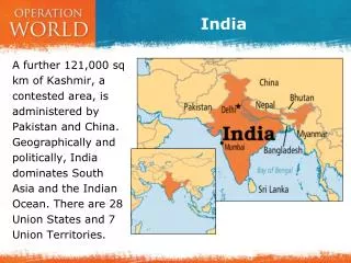
LESSONS LEARNED FROM PAST NOTABLE DISASTERS INDIA PART 1: FLOODS (NOTE: FLOODS ALSO TRIGGER LANDSLIDES). INDIA. NATURAL AND TECH. HAZARDS THAT HAVE CAUSED DISASTERS IN INDIA. FLOODS (LANDSLIDES). GOAL: PROTECT PEOPLE AND COMMUNITIES. SEVERE WINDSTORMS. EARTHQUAKES.

E N D
LESSONS LEARNED FROM PAST NOTABLE DISASTERSINDIAPART 1: FLOODS (NOTE: FLOODS ALSO TRIGGER LANDSLIDES)
NATURAL AND TECH. HAZARDS THAT HAVE CAUSED DISASTERS IN INDIA FLOODS (LANDSLIDES) GOAL: PROTECT PEOPLE AND COMMUNITIES SEVERE WINDSTORMS EARTHQUAKES HIGH BENEFIT/COST FROM BECOMING DISASTER RESILIENT POWER BLACKOUTS ENVIRONMENTAL CHANGE GLOBAL CLIMATE CHANGE
Natural Phenomena that Cause Disasters Planet Earth’s atmospheric-hydrospheric-lithospheric interactions create situ-ations favorable for FLOODS
A “HIMALAYAN TSUNAMII” HIMALAYAN REGION OF NORTHEST INDIA(Floods also trigger landslides)June 24—JULY ??, 2013
Triggered by unusually heavy monsoon rains that don’t usually arrive this early in the mountainous state of Uttarakhand, which borders Nepal and China, the floods and landslides swept away buildings, roads and vehicles.
HIGH POTENTIAL LOSS EXPOSURES IN A FLOOD Entire villages: People, property, infra-structure, business enterprise, government centers, crops, wildlife, and natural resources.
Kedarnath, the home of a deeply revered Hindu temple visited by many pilgrims every year, experienced the maximum devastation.
KEDARNATH (Note: Temple in foreground) KEDARNATH (Note: Temple in Foreground)
IMPACTS • At least 1,000 feared dead • 70,000 evacuated • More than 50,000 people cut off by the waters
DEVASTATING FLOODS IN ASSAM STATE AND IN NORTHEST INDIA(Floods also trigger landslides)June 28—JULY 15, 2012
The Brahmaputra River overflowed during monsoon rains, flooding more than 2,000 villages and destroying homes in the northeast of the country
2012: RECORD BREAKING IMPACTS • Ninety-five dead • Over 2 million homeless. • Half a million evacuees are living in relief camps with disease prone conditions • Damaging landslides hindered relief operations
FLOOD HAZARDS • PEOPLE & BLDGS. • VULNERABILITY • LOCATION • PREPAREDNESS • PROTECTION • EARLY WARNING • EMERGENCY RESPONSE • RECOVERY and RECONSTRUCTION FLOOD RISK POLICY OPTIONS ACCEPTABLE RISK RISK UNACCEPTABLE RISK GOAL: FLOOD DISASTER RESILIENCE INDIA’S COMMUNITIES DATA BASES AND INFORMATION HAZARDS: GROUND SHAKING GROUND FAILURE SURFACE FAULTING TECTONIC DEFORMATION TSUNAMI RUN UP AFTERSHOCKS
A FLOOD RISK ASSESSMENT HELPS GUIDE POLICY ADOPTION AND IMPLEMENTATION FOR FLOOD DISASTER RESILIENCE
DAMAGE FROM INUNDATION EROSION, SCOUR, AND LANDSLIDES LOSS OF FUNCTION ECONOMIC LOSS A FLOOD RISK ASSESSMENT INTEGRATES PHYSICAL EFFECTS AND SOCIETAL IMPACTS TO DETERMINE RISK RISK
CAUSES OF RISK LOSS OF FUNCTION OF STRUCTURES IN FLOODPLAIN INUNDATION INTERACTION WITH HAZARDOUS MATERIALS STRUCTURE & CONTENTS: DAMAGE FROM WATER FLOODS WATER BORNE DISEASES (HEALTH PROBLEMS) DISASTER LABORATORIES EROSION AND MUDFLOWS CONTAMINATION OF GROUND WATER
FLOOD DISASTER RISKS LOSS OF FUNCTION OF BUILDINGS AND INFRASTRUCTURE, RELEASE OF HAZARDOUS MATERIALS, DAMAGE TO CONTENTS, TRANSPORTATION OF DEBRIS, AUTOS, AND HOUSES, ENVIRONMENTAL DEAD ZONES, AND WATER BORNE DISEASES
A RISK ASSESSMENT • A risk assessment involves the probabilistic integration of: • The hazard (e.g., floods) and their potential disaster agents (inundation, erosion, etc) that are directly related to the location of the community and what happens in the regional water cycle.
RISK ASSESSMENT (Continued) • The location of each element of the exposure in relation to the physical demands of the hazard (i.e., inundation, etc.)
RISK ASSESSMENT (Continued) • The exposure (e.g., people, and elements of the community’s built environment), represents the potential loss when the natural hazard occurs.
RISK ASSESSMENT (Continued) • The vulnerability (or fragility) of each element comprising the exposure when subjected to the potential disaster agents.
EVENT VULNERABILITY FLOOD HAZARDS EXPECTED LOSS EXPOSURE PEOPLE STRUCTURES PROPERTY ENVIRONMENT INFRASTRUCTURE Vulnerability: The Driver of Risk
An element’s vulnerability (fragility) is the result of a community’s actions or of nature’s actions that change some part of the regional water cycle (e.g., precipitation, storage, runoff, transpiration, evaporation).
WHAT INCREASES VULNERABILITY MANKIND’S ACTIONS AND NATURE ITSELF CAN CHANGE THE VULNERABILITY OF ELEMENTS AT RISK TO A FLOOD, A PART OF THE REGIONALWATER CYCLE
MANKIND’S CONTRIBUTIONAn element’s vulnerability (fragility) is the result of flaws that enter during the planning, location, siting, design, and construction of a community’s buildings and infrastructure.
MANKIND’S ACTIONS THAT CHANGE SOME PART OF THE WATER CYCLE • Urban development or industrial development in areas that were formerly wetlands. • Locating buildings and infrastructure in a river floodplain.
MANKIND’S ACTIONS THAT CHANGE SOME PART OF THE WATER CYCLE • Actions that increase or decrease river gradients (deforestation, dams, etc). • Actions that change the runoff rate or pattern (e.g., the city’s concrete footprint)
NATURE’S ACTIONS THAT CHANGE THE WATER CYCLE • A flash flood. • Ice jams/ice dams on the river • Rapid melt of snow and ice • Extreme or prolonged precipitation caused by stalled low-pressure weather systems.
REQUIRED INFORMATION FOR A COMPREHENSIVE VULNERABILITY ASSESSMENT
REQUIRED INFORMATION • Physical characteristics of the regional water cycle and drainage system. • Physical characteristics of each river system, its tributaries, and its floodplains.
REQUIRED INFORMATION • Physical characteristics of catchment basins, reservoirs, and wetlands in the region. • Physical characteristics of dikes, levees, and dams controlling water discharge and flooding potential in the region.