Download
1 / 17
170 likes | 253 Vues
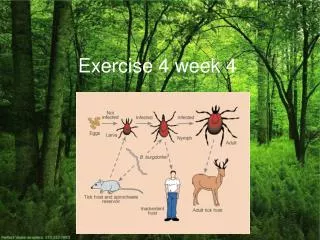
Exercise 4 Updating the City of Corvallis. Chapter 8 of GIS Concepts and ArcView Methods. Introduction. New research park for new companies Sunset Research Park, SW Corvallis 15 years of growth - GIS db needs update! CREATE NEW DATA - on-screen digitizing Buildings, parking lots.

E N D
Exercise 4Updating the City of Corvallis Chapter 8 of GIS Concepts and ArcView Methods
Introduction • New research park for new companies • Sunset Research Park, SW Corvallis • 15 years of growth - GIS db needs update! • CREATE NEW DATA - on-screen digitizing • Buildings, parking lots
But wait !! • New building regulations to project wetlands • How far away are buildings from wetlands? • Do they fall within a BUFFER zone
Exercise 4 • On screen (“heads up”) digitizing • Buffering • Decision-making • Buildings on sensitive wetlands?
Image Data Digital Orthophoto Quads (DOQs) • aerial photographs • camera orientation, terrain • raster images at 1m resolution • 6m positional accuracy at scale of 1:12,000 • Oregon Lambert projection
New GIS Skills • Adding and viewing images • Creating new shape files and adding attribute information. • Using scripts • Downloading data from a web site • Uncompressing data
Buffering • Common operation when performing spatial analysis • Use when you must identify the area surrounding geographic features • SPATIAL PROXIMITY • Buffering generates new polygons around existing points, lines, or polygons
Buffering Steps • identify the THEME, the FEATURE type, DISTANCE to be buffered • new theme of buffer polygons generated • overlap between buffer polygons removed • each polygon in resulting theme coded as being either “inside” or “outside” the buffer zone
(1) Identify Themes, Features & Buffer Distance Theme: RIVER Feature type: LINE Buffer distance: 75 ft Theme: STORES Feature type: POINT Buffer distance: 200 m
(2) New Polygon Buffers Created - New Themes Theme: RIVER Feature type: LINE Buffer distance: 75 ft Theme: STORES Feature type: POINT Buffer distance: 200 m
(3) Overlap Between Buffer Polygons Removed (Ex. 0) Theme: STORES Feature type: POINT Buffer distance: 200 m Theme: RIVER Feature type: LINE Buffer distance: 75 ft
(4) New Topology Built w/ Inside / Outside Polygons Inside = 100 Inside = 1 (Outside) Outside (Inside=1) Inside Outside (Inside=1)
Buffer Widths uniform width variable width
Exercise 4 tips • Save your ArcView project OFTEN!!! • Back up to Zip disk or CD!! • Carefully follow “What to Turn In” section • Due to Janine by Friday, 10/24/03 • Check open lab hours