Download
1 / 22
220 likes | 411 Vues
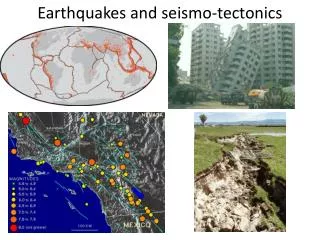
Earthquakes and California Tectonics. Chapman University – ESCU 234 Online Course. Lecture 1 – A Brief History of Earthquakes and Seismology. In the last 500 years, more than 7 million people have died from earthquakes and many more have seen their food sources and local economies destroyed

E N D
Earthquakes and CaliforniaTectonics Chapman University – ESCU 234 Online Course
Lecture 1 – A Brief History of Earthquakes and Seismology • In the last 500 years, more than 7 million people have died from earthquakes and many more have seen their food sources and local economies destroyed • In the 20th century alone, earthquakes have caused over 50% of deaths caused by natural disasters • The hazard that earthquakes present to a growing population is often the primary concern of scientists and engineers
Yet earthquakes have also proven to be a great source of geologic knowledge : - structure of earth’s interior - composition of earth’s interior Seismology, the scientific study of earthquakes, is an extraordinarily young science – only about 100 years. Although people have speculated about the causes of earthquakes for 1,000’s of years.
The Earliest Records • The oldest written records of earthquakes have been traced back to 1831 B.C. in the Shandong Province of China. The record states merely of the “shaking of Taishan Mountain”. • But the record is fairly complete only from 780 B.C. • Some historical reports are so detailed that from them, modern studies have been able to establish the distribution of damage and the size of the earthquakes
Example • On September 2, 1679, the greatest known earthquake near Beijing, China, was mentioned in the records of 121 cities. When modern researchers compared the descriptions of building damage, ground cracks and other features near the source together with reports of shaking, with recent earthquakes, they concluded it was similar to the 1906 San Francisco earthquake (magnitude 7.9). • Despite their careful documentation, Chinese scholars were unable to achieve any insight into the causes of the catastrophic ground shaking • It was thought that earthquakes and other natural disasters were caused by supernatural forces such as the Namazu.
Early Greek Ideas • Thales 580 B.C. believed that movements of water produced earthquakes • Anaximenes 526 B.C. believed that Earth’s interior was hollow and rocks falling in the interior would strike other rocks causing vibrations • Anaxagoras 426 B.C. viewed fire as the cause of at least some earthquakes • Seneca A.D. 63 believed that earthquakes were caused by air finding its way into underground passages Seneca Thales
Aristotle 384-322 B.C. • Like many of his contemporaries was convinced of a “central fire” inside the earth. The fire would rise and if obstructed would burst violently causing vibrations and noise • A later modification suggested that these subterranean fires would burn away supports of the outer parts of the Earth. The ensuing collapse would create earthquakes. • Although incorrect, his ideas were widely accepted until the 18th century. • Other important observations of Aristotle: • Different types of quakes based on shaking was mainly vertical or diagonal • Whether quake was associated with vapors • Places where subsoil is poor are shaken more because of the large amount of “wind” they absorb
Modern Enlightenment 1750 is often referred to as the “year of the earthquakes” because London, England was jolted by earthquakes several times. Still and many writers showed, earthquakes were usually believed to caused by either supernatural causes or causes hypothesized by the Greek scholars of long ago. In fact, a writer in a scientific journal apologized “to those who are apt to be offended by any attempts to give a natural account of earthquakes”. A new era dawned in the 18th century under the influence of Sir Isaac Newton’s writings of waves and mechanics. His laws of motion provided the physical theory needed to explain earthquake waves. Sir Isaac Newton
The Lisbon Earthquake of 1755 • The scientific study of earthquakes received an important boost in 1755 when a disastrous earthquake struck in the Atlantic Ocean, several hundred kilometers south-southwest of Portugal on November 1st. • 60,000 + residents of Lisbon were killed • ocean waves 30-40 above high tide level swamped the city • fires burned for 3 days
The Lisbon earthquake of 1755 was a major source of inspiration for one of the first modern “Fathers of Seismology”, the British engineer John Michell (1724-1793). In his description of the earthquake written in 1760, he classified two types of earthquake waves: • A tremulous vibration; followed by, • Wavelike undulation of the Earth’s surface
Michell also concluded that the speed of earthquake waves could actually be measured from their arrival times at two different points. From eyewitness accounts he calculated that the waves in the Lisbon earthquake traveled about 500 meters per second (m/s). Although incorrect, it was the first attempt at such a calculation.
Robert Mallet and the Great Italian Earthquake of 1857 The earthquake of December 16, 1857 near Naples in southern Italy provided Robert Mallet the opportunity to study seismic effects extensively and lay a firm foundation for modern seismology. Mallet did much to further the interaction between engineering, geology, and mechanics. His goal was to take earthquake studies from a stage of mystery by applying physical and engineering principles to the search for the real nature of earthquakes.
In Mallet’s landmark work “The First Principles of Observational Seismology” he coined much of the basic vocabulary describing earthquakes that we still use. • Mallet is also notable for being the first to work with artificial earthquakes. He exploded charges of gunpowder underground, then recorded the waves by watching the surface of a container of mercury placed at a distance from the charge. A stopwatch gave him the elapsed time between the explosion and ripples on the mercury surface. • From these observations he deduced that earthquake waves travel at different speeds through different materials. For the first time it was clearly understood that seismic waves are affected by the physical properties of the different rocks through which they pass. • - sandy soil 280 m/s • - granite 600 m/s (Too small!)
Believing that earthquakes such as that which struck Naples were produced by volcanic sources, he drew attention to the nearness of volcanoes such as Mt. Vesuvius to the area. From his notion of an explosive source (which is wrong!), Mallet inferred correctly that the seismic waves would start at a point, the focus or hypocenter. • Further, he suggested that seismic waves resembled sound waves traveling in the air. From this he concluded that the first motion of the ground would show a regular direction away from the initiation point. • Used: • objects thrown from heights • overturned objects • directions of cracks in buildings • To calculate the position of a hypocenter. • Based on his studies, Mallet calculated the depth of the Naples earthquake to 6 ½ miles beneath the surface.
Knowing what we do today about earthquakes and seismology, Mallet’s methods were impractical. Nevertheless, this was the first attempt to estimate the origin of an earthquakes motion. Not until 50 years later with the development of the modern seismograph could earthquake hypocentral depths be calculated (and still not all that well today!).
Four Key Earthquakes In the mid to late 1800’s two organizations were created that contributed much to the science of earthquakes - 1857 Geological Survey of India - 1879 United States Geological Survey An early work of the USGS was done by M. L. Fuller in 1912 who published evidence on three extraordinarily large shocks which occurred along the Mississippi River - December 16, 1811 - January 23, 1812 - February 7, 1812 (reportedly the largest)
All together, over 1870 earthquakes shook the area between December 16 and March 16. Eight of these were severe, felt in Louisville, Kentucky, 200 miles away. • Damage occurred over 30,000 to 50,000 square miles bordering the Mississippi River southward from New Madrid, Missouri. • The largest of these shocks awakened President Madison in the White House rang church bells in Boston, Massachusetts, and toppled chimneys in Cincinnati, Ohio. Significance: At the time, it was a geological puzzle why such immense earthquake energy was released in a continental interior. Earthquakes were always considered to occur on the edges of continents.
On June 12, 1897 another very important event struck the province of Assam in northeast India. As reported by Richard D. Oldham, head of the Indian Geological Survey: • The earthquake was felt over an area of 1 ¾ million square miles • Completely devastated 9,000 square miles • Fewer than 1,000 people died because of low population density and few large structures • Shaking (strong) lasted about one minute • Persons were thrown to the ground • Powerful accelerations of the ground threw boulders straight up • Sandy soils behaved as a liquid and reported homes sinking until only the roof was visible • Oldham reported that in heavily shaken areas, people saw visible waves (~ 1 ft. high) moving across the ground • Vertical throw of 35 feet along a deep “thrust” fault R. D. Oldham
The Contribution of the 1906 San Francisco Earthquake The turning point in our understanding of the causes of earthquakes came from the studies of the earthquake that shook central and northern California on April 18, 1906. • No active volcanoes nearby, therefore geologists were not tempted to turn to old Greek notions • Source of the 1906 earthquake lay beneath a readily traversed area that surveyors had already covered with survey markers showing distances and relative heights between points (note that these were not available in either the 1811-1812 and 1897 earthquakes) • This allowed mapping of the ground deformation
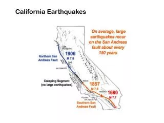
To study the quake the “State Earthquake Investigation Commission” was set up under University of California, Berkeley professor Andrew Lawson. Scientists assembled under Lawson compared geodetic measurements prior to and after the quake. Their report contained the fundamental theory that has dominated seismology to this day. The report concluded that the severe ground shaking had been generated by sudden slip on what Lawson called the San Andreas Fault. The fault had slipped over a section extending for more than 400 km from San Juan Bautista south of San Francisco Bay to a point ~ 250 km north of San Francisco. The San Andreas fault south of San Francisco following the 1906 earthquake.
The Japanese Earthquake of 1923 By the 1920’s scientists were looking for patterns in seismic events that might point to the location of future earthquakes. Dr. Fusukichi Omori, Director of the Seismological Institute of Japan had been studying the apparent distribution of large earthquakes in the vicinity of Honshu. In 1922 Omori wrote that the vicinity near Tokyo was seismically quiet but that regions ~ 60 km away it were active (this is called a seismic gap). Thus he felt the area was due for a particularly devastating earthquake. Approximately one year after his prediction, on September 1, 1923 at about noon when the streets of Tokyo were filled with people, a particularly devastating quake hit, the Kwanto earthquake.
Devastation along Ningyocko St., Tokyo Seismogram from Kwanto Earthquake Refugees in front of the Imperial Palace following the 1923 earthquake Damage at Miyamachi Tagaata-gun Shiuoka-ken