Download
1 / 9
90 likes | 220 Vues
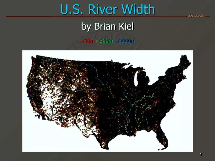
U.S. River Width by Brian Kiel ~30m ~ 300m ~ 3000m. 1. (Width, zoomed in) ~30m ~ 300m ~ 3000m. 2. Wrong method: Hard to use flowlines/centerlines!. Best ArcMap Procedure. Following execution of this model, run script located at http://arcscripts.esri.com/details.asp?dbid=14264.

E N D
Best ArcMap Procedure • Following execution of this model, run script located at http://arcscripts.esri.com/details.asp?dbid=14264
Differences between This Method and Pavelsky's RivWidth • Pavelsky RivWidth code for ENVI/IDL • Problems • Runtime: 2 days for one reservoir • Reliance on inaccurate centerlines • Requires adjustment of parameters locally • My Arc method • Runtime: 2 days for entire US • No reliance on centerlines • No true analytic parameters requiring adjustment • Width at a point is the length of the shortest “perpendicular” line passing through
Input Data Parameters • Polygons • Eliminated polygons of < 4 pixels and the largest polygons such as the Great Lakes. • Did not eliminate lakes/reservoirs. • Points • 3 measurement points in smallest polygons, while point spacing in large polygons is hundreds of m. • Increase the density of width measurements simply by increasing the number of input points.
Analysis • By observation, widths more accurate than those generated by RivWidth • Can analyze data by river or region • Ohio River: mean width 598 m, max. 8702 • San Marcos Basin: mean width 96 m, max. 1080 (reservoir)
Further Work; Publication Definition of river width (Dietrich?) Invert Whipple/Howard (?) equation or apply Manning’s Equation to solve for discharge. Compare widths with those calculated from discharge using Whipple/Howard (?) equation. Quantitatively analyze stream scaling laws Apply width method to foreign countries Could interpolate points (within polygons) to raster product 9