Download
1 / 48
490 likes | 694 Vues
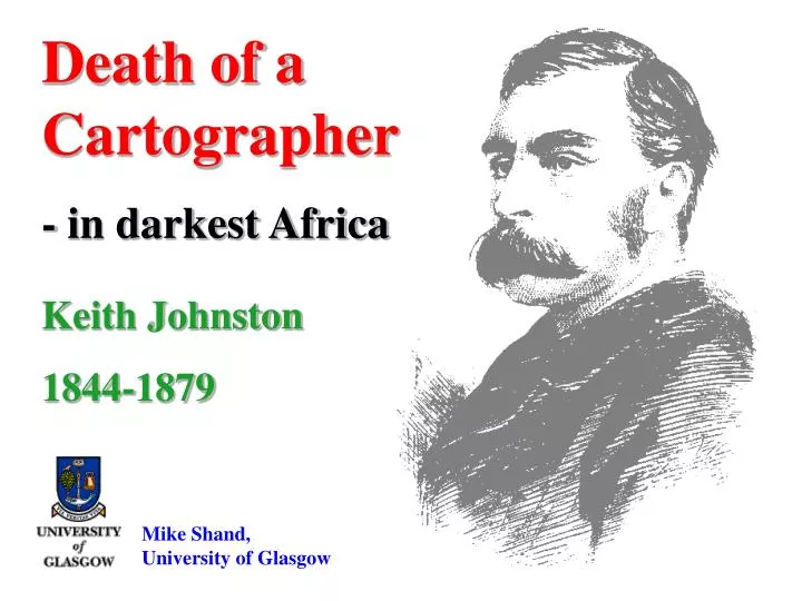
Death of a Cartographer - in darkest Africa. Keith Johnston 1844-1879. Mike Shand, University of Glasgow. Alexander Keith Johnston. Cartographer; Geographer; Explorer Born: 1844, Edinburgh, Scotland Died: 1879, Behobeho, East Africa Aged: 34 Cause of Death: Dysentery

E N D
Death of a Cartographer - in darkest Africa Keith Johnston 1844-1879 Mike Shand, University of Glasgow
Alexander Keith Johnston Cartographer; Geographer; Explorer Born: 1844, Edinburgh, Scotland Died:1879, Behobeho, East Africa Aged:34 Cause of Death:Dysentery Died while leading the Royal Geographical Society East Africa Expedition from Zanzibar to Lake Nyasa.
W & AK Johnston Maps Atlases Globes
Career of Keith Johnston 1860 - Cartographer with Johnston’s, Edinburgh (age 16). 1866 - Superintendant of Maps Stanford’s, London. 1867 - Cartographer with Perthes, Germany (age 23). 1868- Elected Fellow of theRoyal Geographical Society. 1869 - Head of Geographical Dept., Johnston’s, London. 1872 - Assistant Curator and Draughtsman to the R.G.S. 1874 - Cartographer, Surveyor and Explorer, Paraguay. 1875 - Independent Cartographer/Geographer London. 1878 - Leader of R.G.S. East Africa Expedition (age34).
The Exploration of East Africa, 1850-80 Henry Morton STANLEY Richard BURTON David LIVINGSTONE John Hanning SPEKE
The Exploitation of Africa Slave Trade Ivory Trade
Mapping of Africa in 1850's The cumulative labour involved in mapping is well described by Stanley, referring to his journey to rescue Emin Pasha : ‘Mine (mapping) have cost me more labour than the note-taking, literary work, sketching and photographing combined. In the aggregate, the winding of the three chronometers daily for nearly three years, the 300 sets of observations, the calculation of all these observations, the mapping of the positions, tracing of rivers, and shading of mountain ranges, the number of compass-bearings taken, the boiling of the thermometers, the records of the varying of the aneroids, the computing of the heights, and the notes of temperature, all of which are necessary for a good map, have cost me no less than 780 hours of honest work, which, at 6 hours per day, would make 130 working days’ The general methods of survey employed are succinctly described by Speke thus: ‘ My first occupation was to map the country. This is done by timing the rate of march by watch, taking compass bearings along the road, or on any conspicuous marks - as, for instance hills - and by noting the watershed - in short all topographical objects. On arrival in camp every day ascertaining, by boiling a thermometer, of the altitude of the station above the sea level; of the latitude of the station by the meridian altitude of a startaken with the sextant; and of the compass variation by azimuth. Occasionally there was the fixing of certain crucial stations, at intervals of 60 miles or so, by lunar observations, and distances of the sun from certain stars for determining of the longitude by which the original timed - course can be drawn out with certainty on the map by proportion.’
Mapping of Africa in 1850's Map by J H SPEKE 1858
Obituary to Keith Johnston Among African explorers Keith Johnston was distinguished by being both atrained cartographerandprofessional geographerof considerable repute, despite his relative youth. According toDavid Livingstone in 1872 “Keith Johnston knew more about the catchments of Central Africa than the great explorer himself” RGS presidentSir Bartle Frerestated that Keith Johnston “drew most of the fine wall maps in illustration of our Evening Meetings and also some of the best maps in our Journal”
Forward to Darkest Africa London Keith Johnston & Joseph Thomson Depart: London 14 Nov 1878 Arrive: Zanzibar 6 Jan 1879 Suez Canal Aden Zanzibar Zanzibar
Zanzibar 2001 Old British Consulate Dhow Harbour Plaque on Old British Consulate
Zanzibar 2001 Zanzibar UMCA Cathedral built by Bishop Steere, 1879 Memorial window and brass plaque in Zanzibar Cathedral dedicated to Keith Johnston
The Royal Geographical Society East Africa Expedition 1878-80 Chuma Makatubu Keith Johnston (Leader) Joseph Thomson The caravan departed Zanzibar on 18 May 1879 with 150 porters & 5 donkeys
Proposed Route of the East Africa Expedition Zanzibar Lake Tanganyika Lake Nyasa
East Africa Expedition 1878-80 • MAIN AIMS OF THE EXPEDITION • (as instructed by the Royal Geographical Society) • To establish a Route from Dar es Salaam to Lake Nyasa (and possibly onwards to Lake Tanganyika) • To Survey and Map the Route taken • To examine the mountains NE of Lake Nyasa • To make observations on geology, meterology, natural history and ethnology • To obtain information on the inhabitants and products • To enquire into the practicability of constructing and maintaining a telegraph line
Mapping equipment used by 1879 Expedition Aneroid Barometer Prismatic Compass Chronometers Sextant
The Diary of Keith Johnston (Transcribed with explanatory notes by James McCarthy, 2001) Old Consulate, Zanzibar Geog. (Equador). To Bishop Steere’s with Mrs Kirk. Read exercises to end of verbs. Mrs K and girls at Mbweni. To lunch with Dr Robb to meet Mr Wakefield. Dr Robb’s meteorological observations for past 5 years. Rainfall averages about 60 inches greatest in April a second smaller maximum in Nov. Dec.
The Diary of Keith Johnston The caravan left Zanzibar on 18 May 1879 with 150 porters & 5 donkeys May 19 Dar-es Salaam Watches set at 10.30 together. 17 m. fast of mean Zanzibar time on 14 May. After mustering men at 6.30 and serving out ammunition to the 23 carbine men and 20 Enfields were all ready to start. By 12 o’clock the greater part of the caravan was despatched, drum beating and flag flying in front. May 24 Mkuranga-Liwela Morning dull - heavy rain at 5.0am Left Makuranga at 7.10 bearing SSE. Passed a marshy stream east. 7.15 delay 10 minutes repacking donkeys. 7.25 go in jungle. 7.40 SbyW grass and trees …… May 25 Liwela No march today …… very heavy rain tent flooded …… Drew out map of route from Dar es Salaam to Liwela at half inch to one mile. No observations possible.
The Diary of Keith Johnston May 29 Mkamba NO MARCH TODAY Dull morning, night cloudy with slight rain OBSERVATIONS Crux for latitude 7d26m30s; lower limb of moon for time May 30 Mkamba NO MARCH TODAY More rain. Steamy night Keith Johnston and Joseph Thomson go on shooting trip for hippo to nearby lake. Trip involved wading waist and armpit deep in marsh and returning in heavy rain. MAPPING - travelled 19 miles since last Sunday May 31 Mkamba NO MARCH TODAY Very wet morning everything damp Wet night bad rheumatism in back This was the beginning of the fatal dysentery that killed Keith Johnston.
The Diary of Keith Johnston Not untypical examples of camplife and travel as encountered by the expedition
The Diary of Keith Johnston June 9 Boma in jungle Unable to move today after very bad night obliged to keep bed June 10 Boma in jungle Unable to go on severe dysentery. Night wet and miserable. June 11 Boma in jungle Still unable to move. Set a sort of hammock made to carry me tomorrow. June 12 2nd Boma Still very unwell was carried out by Chuma and Sululu on hammock at 7.30 …WbyS …… carried at a sort of jog …… in great pain. Turned out more dead than alive. 7.27sw 739sw 7.49sw 8.2wsw 8.7wsw 815w …… (Thomson’s bearings) June 13 No entries for Friday 13 June June 14Last entry in dairy by Keith Johnston “Expect mail”
The Route to Behobeho Extracts from RGS report by Joseph Thomson June 15 Kimkumbi, River Rufiji A long weary march brought us to the banks of the Rufiji. June 20 Behobeho From the forest we emerged into glorious Behobeho, a haven of peace and plenty. Johnston became gradually weaker from that date and was unable to stand. June 27 Behobeho On the night of June 27 Keith Johnston suffered dreadful pain and passed into an insensible condition, at 4.15 on 28 June he died.
The Death of Keith Johnston “…… on the day we arrived at Behobeho our leader was moved into a hut constructed for him, ……. only too clearly was death stamped on his face”
The Grave of Keith Johnston 50 miles
Search for the Grave of Keith Johnston Search based on: Written descriptions of the gravesite German map showing gravesite location Recorded latitude and longitude values plus values extracted from German map
Joseph Thomson’sdescription of gravesite at Behobeho and his route map from the Rufiji river to Behobeho 1879. “Keith Johnston’s gravelies at the foot of a large tree festooned with graceful creepers, under an arbour of dense evergreen bushes, a few feet to one side rises a sharp conical ant-mound, about 12 feet high. His name and date of death are carved on the bark of the tree. Bago the chief of the village has undertaken to keep the place clear of vegetation.”
William Beardall’s description of the gravesite at Behobeho and his sketches of the grave and Behobeho village, 1880. The village of Behobeho Keith Johnston’s grave “The grass hut built for Mr Johnston and in which he died, is still standing. He is buried about 25 yards off, under a big ‘Inkuyu’ tree, which stands just inside the belt of jungle surrounding the village. His initials and the date of death are cut in the bark of the tree. I have found since that the natives had cleaned the grave. “
Dr Williem Schmidt, German Commissioner, visited the Keith Johnston grave in 1890 resulting in a wooden cross and a fence being erected around the grave. The matter of a permanent gravestone was referred to Parliament, the family, the Royal Geographical Society and to British Consul John Kirk in Zanzibar. As a result, a large desk-shaped slab of Swedish granite was chosen to form the gravestone and engraved as follows: Keith Johnston Died Here At Behobeho 28 June 1879. Aged 34 » In Deo « It is later reported that the slab was too heavy to be carried and was cut into sections. It then took 100 porters 1 year to carry the gravestone sections to Behobeho
Bergassor Bornhardt, German explorer and geologist, visited the Keith Johnston grave and Hatambulo (Mt. Johnston) in 1897 TRANSLATION “Johnston’s grave is situated on the valley bottom of the Behobeho stream, some 100 metres west of the route of 22 July, right in the middle of a small open stand of trees, consisting of marvellous old trees”
Bornhardt plucked 2 leaves from the tree next to the grave of Keith Johnston in 1897 and they were later given to the RGS in a letter from German cartographer Richard Kiepert (also a specialist in mapping Africa they would have met when Johnston studied in Germany). The letter also records the grave at Latitude 7° 38’ SouthLongitude37° 49’ East
German Maps of Behobeho 1900-02 Scale 1:300,000 Only map which actually shows the gravesite of Keith Johnston.
Search for the Grave of Keith Johnston Methodolgy: 1. Plot gravesite location on modern 1:50,000 map using latitude/longitude. 2. Use image processing software to match scanned old and modern maps. 3. Use known points to create similar triangles and graphically fix location.
Search for the Grave of Keith Johnston Problems: 1. Longitude inaccurate by 9 km. 2. Old maps unable to be scanned flat due to the curved atlas binding. 3. Known points not well enough defined for accurate geo-references.
Search for the Grave of Keith Johnston Solutions: 1. Combine all 3 methods to create a ‘best fit’ of the location within 2kms 2. Use 1:50,000 map and GPS to locate the search area with transects 3. Look for fig trees and anthills together
Modern Maps of Behobeho 1:50,000 1982 1:50,000 1957
Mapping equipment used by 2001 Expedition Garmin Etrex GPS Unit Serial Data Cable Laptop with ArcView GIS
Behobeho Rufiji River Sand RiversLodge
Return to Behobeho 2001 Travel to Behobeho
Return to Behobeho 2001 Some of our neighbours at Behobeho
Return to Behobeho 2001 Base camp on the Behobeho sand river and our search area
Return to Behobeho 2001 1:50,000 map 1982 Behobeho River 1km
Return to Behobeho 2001 GPS Tracklog at Behobeho 500m
Return to Behobeho 2001 GPS Waypoints at Behobeho
Results GRAVESITE : General location of gravesite identified within 2 sq.km. Location of site transferred to maps and GIS datasets. GPS co-ordinates established for landmarks at the location. The basis for a further search has been established. KEITH JOHNSTON : The information gathered on Keith Johnston and the references relating to the East Africa Expedition of 1879 has now been added to the knowledge of the Selous Conservation Programme and its newly updated Bibliography
Return to Behobeho 2002 PROPOSALS : Conduct new search with game warden & park staff Search in October during dry season conditions Consider a controlled burn of undergrowth FUTURE PLANS : Find the grave and record accurate GPS co-ordinates Photograph gravestone and arrange its restoration Rename Hatambulo as Hatambulo (Mt Johnston) for use on future maps Complete route from L. Nyasa - L. Tanganyika - Zanzibar WATCH THIS SPACE