Download
1 / 29
290 likes | 402 Vues
Performance of the Experimental 4.5 km WRF-NMM Model During Recent Severe Weather Outbreaks. Steven Weiss, John Kain, David Bright, Matthew Pyle, Zavisa Janjic and Brad Ferrier. Why Examine High Res. WRF Models?.

E N D
Performance of the Experimental 4.5 km WRF-NMM Model During Recent Severe Weather Outbreaks Steven Weiss, John Kain, David Bright, Matthew Pyle, Zavisa Janjic and Brad Ferrier
Why Examine High Res. WRF Models? • Severe weather types (tornadoes, hail, wind damage) can be closely related to convective mode • Tornadoes (discrete supercells) • Damaging wind (bow echoes and QLCSs) • SPC working to increase lead time of watches and provide probabilistic information about tornado, hail, and wind threats in Day 1 Severe Weather Outlooks • Accurate forecasts require knowledge about “where” and “when” storms will develop and how they will evolve • There is a need to better predict convective mode and character of storms(stormscale details) • Environmental clues (CAPE/shear, etc.) may not be sufficient • Operational mesoscale models often lack smaller scale details
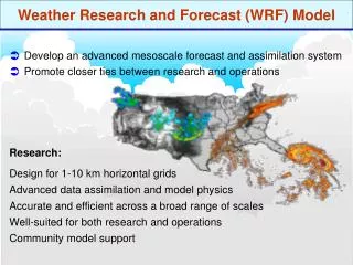
NOAA Hazardous Weather TestbedSPC/NSSL Spring Programs • Spring Programs in 2004 and 2005 examined various configurations of convection-allowing WRF models • Partnerships with EMC, OU-CAPS, and NCAR • Can high resolution WRF provide useful guidance for severe forecasting? • Since April 2004, EMC has been running an experimental 4.5 km version of the WRF-NMM once daily • 36 hour forecasts from 00 UTC start • Very large domain (eastern three-fourths of CONUS)
High Res. WRF-NMM Configuration (No Parameterized Convection) ( see http://wwwt.emc.ncep.noaa.gov/mmb/mmbpll/cent4km/v2/)
Simulated Reflectivity in WRF Output • Simulated Reflectivity • Computed from model predicted grid-resolved hydrometeor fields • Highly dependent on model physics (especially microphysics) • Appealing to forecasters because it closely resembles radar images of precipitation systems • Allows identification of mesoscale and stormscale structures • Easier to subjectively verify model forecasts by comparing directly with observed radar images
Simulated Reflectivity in WRF Output • High res WRF reflectivity can provide mesoscale and near stormscale details not seen in traditional output 21 hour forecasts valid 21 UTC 15 Nov 2005 NAM-WRF 3h Pcpn 4.5 km WRF-NMM Reflectivity
Simulated Reflectivity in WRF Output • Model resolution impacts structural detail, intensity, and realism of simulated reflectivity forecasts 21 hour forecasts 1 km AGL reflectivity valid 21 UTC 20 May 2006 12 km NAM-WRF 4.5 km WRF-NMM
4.5 km WRF-NMM and Radar31 hr WRF forecast valid 07z 6 Nov 2005 F3 tornado 0759z 25 fatalities WRF-NMM 1 km AGL Reflectivity Radar
4.5 km WRF-NMM and Radar21 hr WRF forecast valid 21z 15 Nov 2005 F3 tornado 2030z 1 fatality WRF-NMM 1km AGL Reflectivity Radar
4.5 km WRF-NMM and Radar24hr WRF forecast valid 00z 28 Nov 2005 F3 Tornado 0015z 1 Fatality WRF-NMM 1km AGL Reflectivity Radar
4.5 km WRF-NMM and Radar27hr WRF forecast valid 03z 12 Mar 2006 F3 Tornado 0310z 4 Fatalities WRF-NMM 1km AGL Reflectivity Radar
4.5 km WRF-NMM and Radar27hr WRF forecast valid 03z 12 Mar 2006 F3 Tornado 0310z 4 Fatalities WRF-NMM 1km AGL Reflectivity Radar
4.5 km WRF-NMM and Radar25hr WRF forecast valid 01z 3 Apr 2006 2 F3 Tornadoes 0056 and 0143z 22 Fatalities WRF-NMM 1km AGL Reflectivity Radar
4.5 km WRF-NMM and Radar18hr WRF forecast valid 18z 7 Apr 2006 WRF-NMM 1km AGL Reflectivity Radar
4.5 km WRF-NMM and Radar19hr WRF forecast valid 19z 7 Apr 2006 F3 Tornado 1927z 8 Fatalities WRF-NMM 1km AGL Reflectivity Radar
4.5 km WRF-NMM and Radar20hr WRF forecast valid 20z 7 Apr 2006 WRF-NMM 1km AGL Reflectivity Radar
4.5 km WRF-NMM and Radar21hr WRF forecast valid 21z 7 Apr 2006 WRF-NMM 1km AGL Reflectivity Radar
4.5 km WRF-NMM and Radar22hr WRF forecast valid 22z 7 Apr 2006 WRF-NMM 1km AGL Reflectivity Radar
4.5 km WRF-NMM and Radar23hr WRF forecast valid 23z 7 Apr 2006 WRF-NMM 1km AGL Reflectivity Radar
4.5 km WRF-NMM and Radar24hr WRF forecast valid 00z 8 Apr 2006 WRF-NMM 1km AGL Reflectivity Radar
4.5 km WRF-NMM Summary • On many days the 4.5 km WRF-NMM exhibits credible mesoscale prediction skill of convective systems • Especially during strongly forced situations • Current 4.5 km grid length permits “approximation” of stormscale structures • Convective mode details often very helpful • Discrete cells, quasi-linear and multicell systems • But resolution is too coarse to simulate realistic updrafts • “Large” model updrafts are slower to develop • Not uncommon for model storms to develop 1-2 hours late • Key forecaster challenge • Hi Res WRF-NMM forecasts often appear plausible • How do we know when to believe the stormscale details and when to discount them? • Suggests role for high resolution ensembles