Download
1 / 1
10 likes | 151 Vues
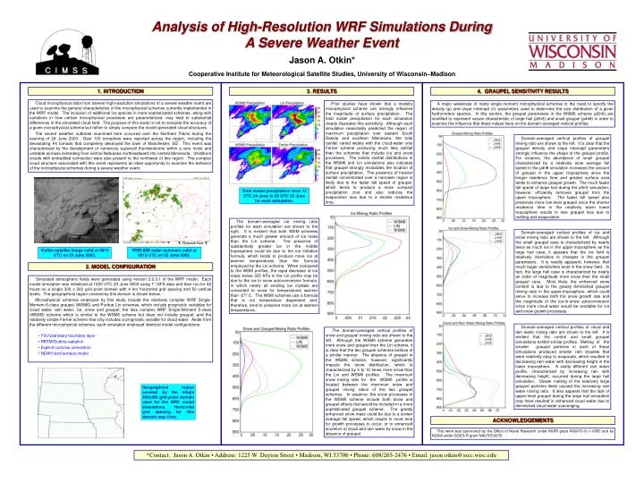
Analysis of High-Resolution WRF Simulations During A Severe Weather Event. Jason A. Otkin* Cooperative Institute for Meteorological Satellite Studies, University of Wisconsin–Madison. 3. RESULTS. 4. GRAUPEL SENSITIVITY RESULTS. 1. INTRODUCTION.

E N D
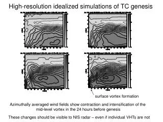
Analysis of High-Resolution WRF Simulations During A Severe Weather Event Jason A. Otkin* Cooperative Institute for Meteorological Satellite Studies, University of Wisconsin–Madison 3. RESULTS 4. GRAUPEL SENSITIVITY RESULTS 1. INTRODUCTION Cloud microphysical data from several high-resolution simulations of a severe weather event are used to examine the general characteristics of the microphysical schemes currently implemented in the WRF model. The inclusion of additional ice species in more sophisticated schemes, along with variations in how certain microphysical processes are parameterized, may lead to substantial differences in the simulated cloud field. The purpose of this study is not to evaluate the accuracy of a given microphysical scheme but rather to simply compare the model-generated cloud structures. The severe weather outbreak examined here occurred over the Northern Plains during the evening of 24 June 2003. Over 100 tornadoes were reported across the region, including the devastating F4 tornado that completely destroyed the town of Manchester, SD. This event was characterized by the development of numerous supercell thunderstorms within a very moist and unstable airmass extending from central Nebraska northeastward into central Minnesota. Stratiform clouds with embedded convection were also present to the northwest of this region. The complex cloud structure associated with this event represents an ideal opportunity to examine the behavior of the microphysical schemes during a severe weather event. Prior studies have shown that a model’s microphysical scheme can strongly influence the magnitude of surface precipitation. The total model precipitation for each simulation clearly illustrates this sensitivity. Although each simulation reasonably predicted the region of maximum precipitation over eastern South Dakota and southern Minnesota, the total rainfall varied widely with the cloud-water only Ferrier scheme producing much less rainfall than the schemes that include ice and snow processes. The similar rainfall distributions in the WSM6 and Lin simulations also indicates that graupel strongly modulates the location of surface precipitation. The presence of heavier rainfall concentrated over a narrower region is likely due to the faster fall speed of graupel, which tends to produce a more compact precipitation core and also reduces the evaporation loss due to a shorter residence time. A major weakness of many single-moment microphysical schemes is the need to specify the density (ρ) and slope intercept (n) parameters used to determine the size distribution of a given hydrometeor species. In this section, the graupel parameters in the WSM6 scheme (ρ5n6) are modified to represent values characteristic of large hail (ρ9n3) and small graupel (ρ4n8) in order to examine the influence that these values have on the domain-averaged vertical profiles. Domain-averaged vertical profiles of graupel mixing ratio are shown to the left. It is clear that the graupel density and slope intercept parameters strongly influence the shape of the graupel profile. For instance, the abundance of small graupel characterized by a relatively slow average fall speed in the ρ4n8 simulation increases the amount of graupel in the upper troposphere since the longer residence time and greater surface area tends to enhance graupel growth. The much faster fall speed of large hail during the ρ9n3 simulation, however, efficiently removes graupel from the upper troposphere. The faster fall speed also preserves more low-level graupel since the shorter residence time in the relatively warm lower troposphere results in less graupel loss due to melting and evaporation. Total model precipitation from 12 UTC 24 June to 06 UTC 25 June for each simulation. The domain-averaged ice mixing ratio profiles for each simulation are shown to the right. It is evident that both WSM schemes generate a much greater amount of ice mass than the Lin scheme. The presence of substantially greater ice in the middle troposphere could be due to the ice initiation formula, which tends to produce more ice at warmer temperatures than the formula employed by the Lin scheme. When compared to the WSM profiles, the rapid decrease of ice mass below 325 hPa in the Lin profile may be due to the ice to snow autoconversion formula, in which nearly all existing ice crystals are converted to snow for temperatures warmer than -27º C. The WSM schemes use a formula that is not temperature dependent and, therefore, tend to preserve more ice at warmer temperatures. Domain-averaged vertical profiles of ice and snow mixing ratio are shown to the left. Although the small graupel case is characterized by nearly twice as much ice in the upper troposphere as the large hail case, it appears that the ice field is relatively insensitive to changes in the graupel parameters. It is readily apparent, however, that much larger sensitivities exist in the snow field. In fact, the large hail case is characterized by nearly an order of magnitude more snow than the small graupel case. Most likely, the enhanced snow content is due to the greatly diminished graupel mixing ratio in the upper-troposphere, which could serve to increase both the snow growth rate and the magnitude of the ice-to-snow autoconversion since more cloud water would be available for ice and snow growth processes. Visible satellite image valid at 0015 UTC on 25 June 2003. WSR-88D radar summary valid at 0015 UTC on 25 June 2003. 2. MODEL CONFIGURATION Simulated atmospheric fields were generated using version 2.0.3.1 of the WRF model. Each model simulation was initialized at 1200 UTC 23 June 2003 using 1° GFS data and then run for 42 hours on a single 300 x 300 grid point domain with 4 km horizontal grid spacing and 50 vertical levels. The geographical region covered by this domain is shown below. Microphysical schemes employed by this study include the relatively complex WRF Single-Moment 6-class graupel (WSM6) and Purdue Lin schemes, which include prognostic variables for cloud water, rain water, ice, snow and graupel; the less complex WRF Single-Moment 5-class (WSM5) scheme which is similar to the WSM6 scheme but does not include graupel; and the relatively simple Ferrier scheme that only includes a prognostic variable for cloud water. Aside from the different microphysical schemes, each simulation employed identical model configurations: Domain-averaged vertical profiles of cloud and rain water mixing ratio are shown to the left. It is evident that the control and small graupel simulations exhibit similar profiles. Melting of the smaller graupel particles in each of these simulations produced smaller rain droplets that were relatively easy to evaporate, which resulted in decreasing rain water with decreasing height in the lower troposphere. A vastly different rain water profile, characterized by increasing rain with decreasing height, occurred during the large hail simulation. Slower melting of the relatively large graupel particles likely caused the increasing rain water mixing ratio. It also appears that the lack of upper-level graupel during the large hail simulation may have resulted in enhanced cloud water due to diminished cloud water scavenging. • YSU planetary boundary layer • RRTM/Dudhia radiation • Explicit cumulus convection • NOAH land surface model The domain-averaged vertical profiles of snow and graupel mixing ratio are shown to the left. Although the WSM6 scheme generates more snow and graupel than the Lin scheme, it is clear that the two graupel schemes behave in a similar manner. The absence of graupel in the WSM5 scheme, however, significantly impacts the snow distribution, which is characterized by 5 to 10 times more snow than the Lin and WSM6 profiles. The maximum snow mixing ratio for the WSM5 profile is located between the maximum snow and graupel mixing ratios of the two graupel schemes. In essence, the snow processes in the WSM5 scheme include both snow and graupel effects that would be included in a more sophisticated graupel scheme. The greatly enhanced snow mass could be due to a slower average fall speed, which results in more time for growth processes to occur, or to enhanced accretion of cloud and rain water by snow in the absence of graupel. Geographical region covered by the single 300x300 grid point domain used for the WRF model simulations. Horizontal grid spacing for this domain was 4 km. ACKNOWLEDGEMENTS This work was sponsored by the Office of Naval Research under MURI grant N00015-01-1-0850 and by NOAA under GOES-R grant NA07EC0676. *Contact: Jason A. Otkin • Address: 1225 W. Dayton Street • Madison, WI 53706 • Phone: 608/265-2476 • Email: jason.otkin@ssec.wisc.edu