Download
1 / 15
150 likes | 250 Vues
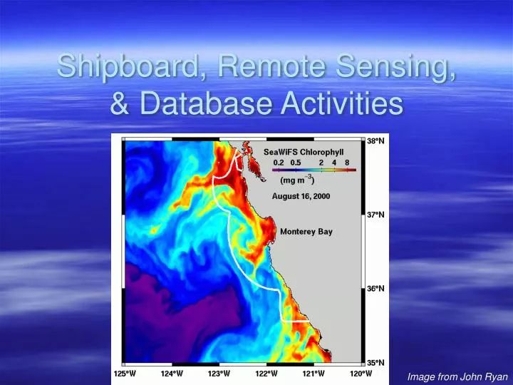
Shipboard, Remote Sensing, & Database Activities. Image from John Ryan. Kudela Lab. Shipboard Data: - Underway shipboard data (TSG, Fluor) - CTD data (with fluor, ancillary measurements) - Bottle chlorophyll and ancillary measurements - Nutrients (prior to August 2006) Remote Sensing:

E N D
Shipboard, Remote Sensing, & Database Activities Image from John Ryan
Kudela Lab Shipboard Data: - Underway shipboard data (TSG, Fluor) - CTD data (with fluor, ancillary measurements) - Bottle chlorophyll and ancillary measurements - Nutrients (prior to August 2006) Remote Sensing: - NRT access to satellite data - Interface with NOAA through Dave Foley and Rick Stumpf - Process-oriented studies Database: - Took over in 2006 - Interface with Brian Fulfrost, Todd Anderson, Rondi Robison
Shipboard Data • All CTD data through May 2006 consistently reprocessed • Manually inserted surface values, fluor from upcast when necessary • Underway data through July 2005 QA/QC’d • All chlorophyll and nutrient data QA/QC’d • GFF, 1 µm, 10 µm, Nitrate, Phosphate, Silicate • Ancillary data in various stages of processing
Remote Sensing • Near-Real Time data available @ • http://oceandatacenter.ucsc.edu/NRT/ • Also from CIMT webpage • Complete dataset from Rick Stumpf for SeaWiFS (1997-2005) available • Better cloud-masked data for CoastWatch SST available • Working on iterative EOF method to develop cloud-free imagery
Mean chlorophyll, Monterey Mean 2003
Chlorophyll, Monterey, coastal & offshore Coastal Offshore
CIMT Database Activities • Took over as lead in 2005/2006 • Progress: • Mapped existing MySQL database • Moved to new hardware, with backup • Todd Anderson has been keeping the LAS up • Collecting data from data providers for update • To Do: • Hire database support person • Probably move to PostGres for better mapserver support • Working with Brian Fulfrost and Rondi on data output
Moving from Science to End-Users • Established collaboration with CCLEAN • Added urea, ammonium measurements for 2006 • Mapping satellite data to river flow • Outreach to Dave Jessup @ OSPRS • Providing customized satellite imagery • Working with them on non-point source pollution issues • Working with CDHS, provided backround and imagery to Animal Planet, Sea Studios • NOAA is interested in testing improved GNOME model for event tracking