Download
1 / 1
10 likes | 165 Vues
Repeat-Pass Multi-Temporal Interferometric SAR Coherence Variations with Amazon Floodplain and Lake Habitats Hahn Chul Jung and Doug Alsdorf School of Earth Sciences, The Ohio State University, Columbus, OH (jung.196@osu.edu). ABSTRACT.

E N D
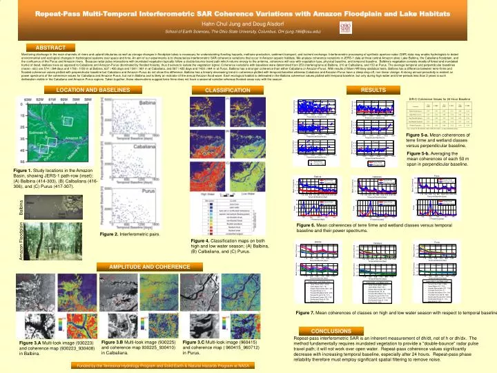
Repeat-Pass Multi-Temporal Interferometric SARCoherenceVariations with Amazon Floodplain and Lake HabitatsHahn Chul Jung and Doug Alsdorf School of Earth Sciences, The Ohio State University, Columbus, OH (jung.196@osu.edu) ABSTRACT Monitoring discharge in the main channels of rivers and upland tributaries as well as storage changes in floodplain lakes is necessary for understanding flooding hazards, methane production, sediment transport, and nutrient exchange. Interferometric processing of synthetic aperture radar (SAR) data may enable hydrologists to detect environmental and ecological changes in hydrological systems over space and time. An aim of our experiments is to characterize interferometric SAR coherence variations that occur in Amazon aquatic habitats. We analyze coherence variations in JERS-1 data at three central Amazon sites; Lake Balbina, the Cabaliana floodplain, and the confluence of the Purus and Amazon rivers. Because radar pulse interactions with inundated vegetation typically follow a double-bounce travel path which returns energy to the antenna, coherence will vary with vegetation type, physical baseline, and temporal baseline. Balbina’s vegetation consists mostly of forest and inundated trunks of dead, leafless trees as opposed to Cabaliana and Amazon-Purus (dominated by flooded forests), thus it serves to isolate the vegetation signal. Coherence variations with baselines were determined from 253 interferograms at Balbina, 210 at Calbaliana, and 153 at Purus. The average temporal and perpendicular baselines (mean std.) are 574 394 days and 1708 1159 m at Balbina, 637 435 days and 1381 981 m at Cabaliana, and 587 425 days and 1430 964 m at Purus. Balbina has a stronger coherence than either Cabaliana or Amazon-Purus. With results of Mann-Whitney statistical tests, Balbina has a difference between terre-firme and flooded coherence values plotted with perpendicular baseline but Cabaliana and Amazon-Purus do not show this difference. Balbina has a linearly decreasing trend in coherence plotted with temporal baseline whereas Cabaliana and Amazon-Purus have a steep drop-off, non-linear change. A strong annual periodicity is evident on power spectrums of the coherence values for Cabaliana and Amazon-Purus, but not in Balbina and is likely an indicator of the annual Amazon flood wave. Each ecological habitat is delineated in the Balbina coherence values plotted with temporal baseline, but only during high water and time-periods less than 2 years is such delineation visible in the Cabaliana and Amazon-Purus regions. Taken together, these observations suggest terre-firme does not have a seasonal variation whereas flooded areas vary with the season. LOCATION AND BASELINES RESULTS CLASSIFICATION SIR-C Coherence Values for 24-Hour Baseline Avg.: average for all coherence values within the region, : their standard deviation Figure 5-a. Mean coherences of terre firme and wetland classes versus perpendicular baseline. Figure 5-b. Averaging the mean coherences of each 50 m span in perpendicular baseline. Figure 1. Study locations in the Amazon Basin, showing JERS-1 path-row (inset); (A) Balbina (414-303), (B) Calbaliana (416-306), and (C) Purus (417-307). Balbina Figure 6. Mean coherences of terre firme and wetland classes versus temporal baseline and their power spectrums. Figure 2. Interferometric pairs. Figure 4. Classification maps on both high and low water season; (A) Balbina, (B) Calbaliana, and (C) Purus. Amazon Floodplain AMPLITUDE AND COHERENCE Figure 7. Mean coherences of classes on high and low water season with respect to temporal baseline. High are data from the months of May, June, and July only. Low are data from the months of October, November, and December only. CONCLUSIONS Repeat-pass interferometric SAR is an inherent measurement of dh/dt, not of h or dh/dx. The method fundamentally requires inundated vegetation to provide a "double-bounce" radar pulse travel path; it will not work over open water. Repeat-pass coherence values significantly decrease with increasing temporal baseline, especially after 24 hours. Repeat-pass phase reliability therefore must employ significant spatial filtering to remove noise. Figure 3.B Multi-look image (930225) and coherence map 930225_930410) in Calbaliana. Figure 3.C Multi-look image (960415) and coherence map ( 960415_960712) in Purus. Figure 3.A Multi-look image (930223) and coherence map (930223_930408) in Balbina. Funded by the Terrestrial Hydrology Program and Solid Earth & Natural Hazards Program at NASA