Download
1 / 40
400 likes | 426 Vues
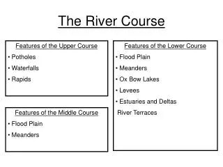
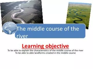
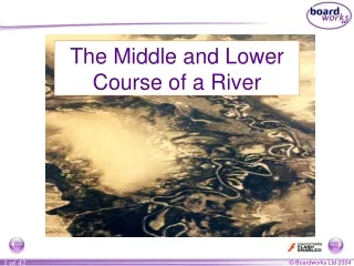
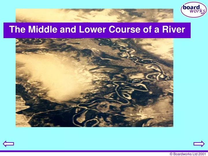
The Middle and Lower Course of a River. How is material transported downstream?. Traction. Saltation. Suspension. Solution. What landforms are found in the Middle and Lower Course of a River?. Meanders Oxbow Lakes Floodplains and Levees Deltas. The Middle and Lower Course of the Rhone.

E N D
How is material transported downstream? Traction Saltation Suspension Solution
What landforms are found in the Middle and Lower Course of a River? • Meanders • Oxbow Lakes • Floodplains and Levees • Deltas
The Middle and Lower Course of the Rhone Geneva Genissiat Source of the Rhone 200km in the Swiss Alps Lyon Massif Central Alps Beauchastel Donzere Caderousse Avignon The Camargue Mediterranean Sea HEP station
The Rhone at Avignon The ‘Pont d’Avignon’ does not stretch across the Rhone anymore…some of the arches were destroyed in a flood
The Cote du Rhone…… the lower course of the Rhone Valley is famous for its vineyards
The Rhone – Lower and Middle Course Hydrograph of the Durance (a tributary of the Rhone) • Study the hydrograph and the map of the Durance. • Describe how the discharge varies throughout the year. • Explain these variations in discharge incorporating the following terms: • EvapotranspirationSnowfallSource
Tributaries of the Rhone Alps Isere Massif Central Drome Ardêche Durance How have these tributaries contributed to the unpredictable flooding of the Rhone?
The Rhone – Lower and Middle Course Flood markings at Caderousse The problems: 1) For several centuries, the inhabitants of the Rhone suffered many floods. 2) In addition, there were water shortages due to the seasonal variations in the flow of water. 3) There was also an increasing need for energy in the 1950s and 1960s. How do you think they solved these problems?
The Rhone – Lower and Middle Course • How was the Rhone tamed? • Solution : Large dams were built by the Compagnie Nationale du Rhone from the late 1930s. For example, the Genissiat Dam was started in 1937. • These dams are multi-purpose schemes. • They hold back the Spring melt water and so stop the floods. • They release this water in the dry Summer to irrigate the intensive fruit and vegetable growing areas and the many vineyards on the slopes of the Rhone valley. The water is also used for cooling in the two, nuclear power plants near Genissiat – Beugy and Creys-Malville • In addition, the dams produce HEP (Hydroelectric Power). The whole French Rhone produces over 16 million MW (compared to 65 million MW produced by all French HEP plants).
Revetments on the Rhone near Caderousse How do these revetments prevent flooding in this part of the Rhone? marker measuring discharge
Dams on the Rhone This is a dam generating HEP near Beauchastel
The dams generate HEP which…. HEP generated near Donzere provide the power to run the TGV in the Rhone valley
Deposition A river deposits all or some of its load when there is too much material to carry. This is likely to happen when extra material is added into the river and/or when the river loses velocity. If this happens before the river reaches its mouth, braiding can occur. This simply means that the river splits into two or more channels due to the deposition. The ‘islands’ formed are called eyots or ayots. Braiding in the River Ouveze (tributary of the Rhone)
Oxbow Lakes When the river floods it breaks through the thin meander neck and the river takes the easier, straight course. This leaves the meander loop ‘cut off’ as an oxbow lake. Over time, the oxbow lake will become colonised by vegetation. new course of the river Meander neck becomes smaller oxbow lake
Caderousse near Orange This was an old meander loop of the Rhone. The meander loop was deliberately ‘cut off’ to straighten the river. Why do you think this happened?
Floodplain Formation Floodplains and levees are formed by deposition in times of river flood. The river’s load is composed of different sized particles. When a river floods it deposits the heaviest of these particles first. The larger particles, often pebble-sized, form the LEVEES. The sands, silts and clays are similarly sorted with the sands being deposited next, then the silts and finally the lightest clays. This deposition makes up the FLOODPLAIN.
Floodplain of the Rhone Orchard Old floodplain of the Rhone … The large pebbles absorb the heat of the sun. How do you think the pebbles got to be here?
Delta Formation Annotate the delta with the following labels: silt clay sand Delta are found at the mouth of a river, where the river meets the sea. At this point the river is carrying too much load for its velocity and so deposition occurs. The top of the delta is a fairly flat surface. This is where the coarsest river load is dropped. The finer particles are carried into deeper water. The silt is dropped to form a steep slope on the edge of the delta while the clay stays in suspension until it reaches the deeper water.
The mouth of the Rhone Petit Rhone Grand Rhone The ‘Grand Rhone’ Mediterranean Sea
The Camargue…The Rhone’s Delta The area of the Rhone’s delta is known as the Camargue. The Rhone’s delta is an example of an arcuate or fan delta. This delta, home to nine thousand people, has grown so large mainly due to vast amounts of sediment that the Rhone has deposited over the years and the low tidal range of the Mediterranean.
The Camargue Most of people that live in the Camargue are farmers. Rice, fruit and vines are grown, especially in the northern part of the delta. Nevertheless, most of the delta is infertile and only used for cattle and horses. The Camargue also attracts over 1 million tourists mainly due to its status as an important wildfowl reserve (designated Regional Nature Park in 1970). Wild boars, horses, geese and even pink flamingos are found here!
The Camargue There is also heavy industry in the Camargue. It is situated at the mouth of the Rhone. Look at the photo below. It shows oil refineries near Port St Louis. What are the advantages of this site for industry? Why do deltas attract heavy industry, such as oil refineries, rather than light industry? The Camargue Port St Louis Mediterranean Sea
Meander Bend on the River Conwy A B Explain why there is more deposition at ‘A’ rather than at ‘B’.
Sketch this plan view of a meander bend and label the line of highest velocity.
Draw the following four diagrams in the correct order of oxbow lake formation. Match 3 of the diagrams with the most appropriate explanation from ‘A’, ‘B’ and ‘C’. 2. 3. 4. X =erosion on the outside of the meander bend 1. X X X X X A. The river floods and erodes through the thin meander neck. The river now takes the easier, straight course. The meander loop is left as an oxbow lake. B. The river meanders. The fastest flow is therefore on the outside of the bend. This fast current erodes the meander neck through the processes of erosion. C. The meander neck is further eroded until only a thin piece of land separates the two channels.
Name the river landform shown in this aerial photograph. What else can you identify? How can you tell that this is not the Upper Course of a river?
This is a cross section of a floodplain. Draw a simple sketch of the diagram and annotate with the following labels Sands Levees Clays and silts
The River Conwy has deposited material in this section of its course. Suggest reasons why this has happened.
This is a cross section of a meander bend. Sketch the diagram and mark on the following River Cliff Fastest velocity Slip off slope Undercutting Area of deposition
Which of the following landforms are primarily caused by: * processes of erosion? * processes of deposition? * a mixture of erosion and deposition? Draw out the table and insert the following landforms into the correct column. Indicate whether they are predominately found in the Upper or Lower Course by inserting a ‘U’ or ‘L’ after each feature. V-shaped valleys Rapids Interlocking spurs Deltas Meanders Floodplains Levees Waterfalls Oxbow lakes Erosion Deposition Erosion & Deposition
Write a list of land uses in the middle and lower course of the Rhone (use place names where possible). How does the land use of the lower course of a river contrast with the upper course?