Download
1 / 21
220 likes | 421 Vues
Ocean Currents. Essentials of Oceanography. Wind-driven Ocean Circulation. Surface ocean circulation mixed layer above top 100 m controlled by winds + coriolis Overhead wind patterns Wind blows against surface- friction sets water into motion

E N D
Ocean Currents Essentials of Oceanography
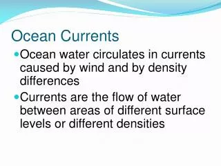
Wind-driven Ocean Circulation • Surface ocean circulation • mixed layer above top 100 m • controlled by winds + coriolis • Overhead wind patterns • Wind blows against surface- friction sets water into motion • Continents interfere with the winds and redirect airflow • Result- circulation cells within each ocean basin
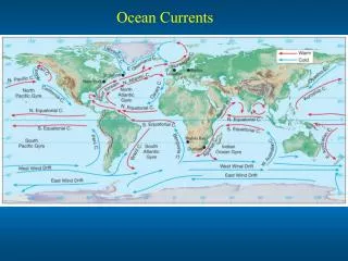
Gyres • Gyre - • closed, circular flow of water around an ocean basin • 5 gyres: • North Atlantic • South Atlantic • North Pacific • South Pacific • Indian Ocean • Plus circulation around Antarctica- closed circuit • wind and water can freely flow around Antarctica
Western Boundary Currents • Flow from equator to pole along western margin of basins • Strong, fast, narrow, focused flow • Transports heat to higher latitudes
Gulf Stream • Good example of a Western Boundary • Current that flows like a river- amount of water carried = 100x discharge from all rivers! • First mapped by Ben Franklin • Major mechanism for transport of heat to North. • Climate in England vs. Newfoundland
Eastern Boundary Currents • Eastern flow more diffuse, wider, slower • Cold water currents
Divergence and Convergence • Where currents or current and land come together or split apart • Convergence leads to downwelling • Divergence leads to upwelling- brings cold, nutrient-rich water up from about 500 m • 2 important areas of upwelling • Pacific equatorial region • Near shore • Along shore winds force water off the coast - creates low water pressure • Eastern margins of ocean basins - Calif. Coast, Peru
El Niño- Southern Oscillation (ENSO) • Represents interactions between: • Atmospheric circulation • Ocean circulation • Climate • Begins in equatorial Pacific, but has global effects • Cause is not well understood • El Nino refers to changes in ocean circulation • Named for anomalous warm current off Peru that occurs at Christmas time • Normally - cold current off of Peru due to upwelling
El Niño- Southern Oscillation (ENSO) • Southern Oscillation • Refers to changes in atmospheric conditions • Oscillation in the distribution of high and low pressure systems across the equatorial Pacific • “Affect wind patterns, which affects surface ocean circulation.
El Niño- Southern Oscillation (ENSO) • Develops when: * Sea surface temperatures (SST) in tropical eastern Pacific Ocean are warmer than normal * pressure patterns weaken (and may reverse) * trade winds weaken (and may reverse)
Southern Oscillation Index (SOI) • Pressure values in the eastern Pacific (Tahiti) and western Pacific (Darwin, Australia) are monitored • SOI = pressure departure at Tahiti - pressure departure at Darwin • SOI < 0 = Normal • SOI > 0 = ENSO
Normal El Nino
Normal years Lower pressure over Indonesia Higher pressure over eastern equatorial Pacific Driven by strong trade winds Weak equatorial counter current Strong upwelling near Peru (and Calif) W. Pac ~ 8º warmer than E Pac. Rain in western Pacific, dry in eastern Pacific El Nino years Higher pressure over Indonesia Lower pressure over eastern Pacific Decreased pressure gradient across the equatorial Pacific weakens trade winds Stronger countercurrent transports warm water to the east Reduced upwelling Shift in rainfall to the east ENSO Comparison La Nina is when conditions are more intensely “normal”
Periodicity • ENSO periodicity 2-7 years • ~1 event every 4 years for past century and 1 strong event per decade • But duration and extent variable (each unique) • Appear to be becoming more frequent over past few decades • 1990-1998 -- prolonged ENSO conditions • Natural variability vs. Global warming effects
Oceanic Deep-water Circulation • Subsurface currents arise from the density differences between water masses • Produced by the variations in water temperature (thermal effect) and salinity (haline effect) • Collectively referred to as thermohaline circulation
Thermohaline Circulation • Evaporation and lower temperatures cool surface waters from ~ 45º N and ~ 45º S latitude to the poles • Cold (and therefore dense) polar water sinks and then drifts equatorward, below warmer, less dense surface water • Cold water descends to a depth of corresponding density, 'sliding' under less dense water and over more dense water • Deep waters slowly return to the surface (after ~1000 years) through upwelling along the equator and in coastal regions
Global Circulation • NADW sinks and flows southward along the western side of the Atlantic Ocean • NADW and AABW mix in the Antarctic Circumpolar Current • Mixed water mass of NADW and AABW flows northward into the Indian and Pacific Oceans • Upwells in the N. Pacific and Indian Oceans and returns to the south as warm shallow waters
Summary • Surface circulation is driven by global wind patterns • El Nino is a warming of the west coast of South America and causes a disruption of global precipitation • Deep water circulation is driven by gravity through density changes caused by temperature and salinity