Download
1 / 30
380 likes | 762 Vues
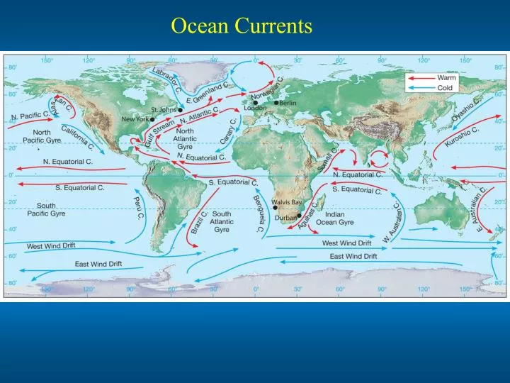
Ocean Currents. Open-Ocean Wind driven Surface Current. Ekman Effect. Ekman Spiral. Ekman transport. The integrated water mass transport is at the right angle, 90 degree, to the wind direction, known as Ekman transport. Ekman layer. Ekman layer. Ocean Gyres.

E N D
Ekman Spiral Ekman transport The integrated water mass transport is at the right angle, 90 degree, to the wind direction, known as Ekman transport. Ekman layer Ekman layer
Barents Sea Arctic Ocean
Oceanic eddies Land + _
Deep ocean circulation heating cooling New idea Upper surface water increases its density either directly by cooling or indirectly when ice freezes out to eject salt, and thus, increasing the density of the remaining water. 1. North Atlantic cooling effect in the winter. 2. Antarctic freezing effect
1. Deep water formation a. North Atlantic Deep Water Source: Greenland Sea Labrador Sea b. Mediterranean Deep Water Source: Mediterranean Sea d. Pacific Intermediate Water Sources: Bering Sea c. Antarctic Intermediate Water Sources: Wedell Sea and Ross Sea Greenland Sea Labrador Sea Mediterranean Sea Wedell Sea Ross Sea
El Niño and La Niña El Niño is characterized by unusually warm ocean temperatures in the Equatorial Pacific, as opposed to La Niña, which characterized by unusually cold ocean temperatures in the Equatorial Pacific. El Niño is an oscillation of the ocean-atmosphere system in the tropical Pacific having important consequences for weather and climate around the globe. 2011 El Niño
Walker circulation
Bjerknes’s (Nov. 2, 1897- Jul. 7, 1975, Norwegian- American meteorologist) air-sea interaction argument What causes the turnabout from warm phase to cold phase? Why do El Niños typically last only 12-18 months? Why do they usually shut down rapidly and switch from warm phase to cold phases or from cold phase to warm phase? Walker circulation Weakened Walker circulation
Kelvin wave a. Small scale Kelvin wave
b. Large-scale Kelvin wave In a rotating frame, large-scale kelvin wave must be: 1. a boundary wave. 2. propagating with the boundary on its right in the North. hemisphere. 3. a trapped wave decaying from the boundary. c. Equatorial Kelvin wave P C P C North South X X
Western Pacific Eastern Pacific warm cold El Niño year Thermocline Normal year upwelling Rossby wave upwelling downwelling Kelvin wave Equator downwelling Rossby wave upwelling upwelling thermocline
Vertical temperature anomalies along the equator during 1997-1998 El Niño event. February 1997 160W 80W January 1998
Southern Oscillation Darwin Tahiti 1958-1998 Sea level pressure anomaly at Tahiti and Darwin
Southern Oscillation Index (SOI): defined as the pressure difference between Tahiti in the southeast Pacific and Darwin in the western Pacific. Negative SOI corresponds to El nino Positive SOI corresponds to La nina. (ENSO)
Impact of ENSO on Global Climate Rainfall anomaly during 1997-1998 El nino East Europe California East China Florida India Indonesia Amazon Southern Africa East Africa Northern Australia Uruguay Why an anomaly, such as ENSO in the equatorial region, can affect climate thousand miles away in mid and high latitude?
El Niño/La nina and hurricane 10 hurricane days during El nino years, 27 hurricane days during non-El nino years. Long running El Nio of 1991-1994, hurricane days of 8, 16, 10, and 7.
Chris Landsea did a statistics of hurricane damage along the three coastal locations of the US, the Gulf Coast, the Florida Peninsula, and the US East Coast. He showed that in the 10 coldest years during the recent 41 year period, the Coast hurricane spawned damage was 55 billion, while only 2.5 billion in the 10 warmest ENSO years. But Chris further pointed out that although the ENSO is typically a very strong modulator of US hurricanes when ENSO is in very cold or very warm phase, it is usually not a major player in those years of small magnitude warm or colder or neutral water conditions.