Download
1 / 21
210 likes | 335 Vues
The Global Positioning System. Rebecca C. Smyth April 17 - May 2, 2001 . GPS-Global Positioning System. Department of Defense navigation system

E N D
The Global Positioning System Rebecca C. Smyth April 17 - May 2, 2001
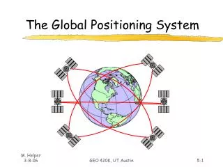
GPS-Global Positioning System Department of Defense navigation system Triangulation from a constellation of 24 satellites broadcasting pseudo-randomly coded signals on radio waves (speed of light) from known positions (given by orbital ephemerides) at very precise time intervals. Satellites at altitude of 20,200 km; distributed in 6 orbital planes with inclination of 55 degrees to equator Four or more satellites visible at all times anywhere in world. First satellite launched February 22, 1978
GPS-Global Positioning System Coordinates are determined using known satellite positions and the measured distances between those satellites and the unknown position at a precise time. A GPS receiver determines its position in three dimensions: x, y, and z. The height (z) coordinate is different from the horizontal coordinates (x and y) both in how it is defined and how accurately it can be measured.
GPS Data - Signal Types Single frequency C/A-code (Civilian Access; Coarse Acquisition) - 1.023 MHz chipping rate Single frequency P code (Precise; Protected, or Precision); becomes Y-code when encrypted - 10.23 MHz chipping rate; only 2 satellites have P-code, the rest have Y-code. Dual frequency Carrier Phase (L1 and L2) - L1 frequency = 1575.42 MHz (λ = 19 cm), L2 frequency = 1227.6 MHz (λ = 24.4 cm). L1 carries C/A code, P code, and Navigation message L2 carries P code only
GPS Solutions Simple, Typical, or Pseudo-range - accuracy of +/- 100m with SA turned on or +/- 20 to 25m with SA off (ex. uncorrected solutions using GeoExplorer or Garman receivers) SA (Selective Availability) - dithering or introduction of a clock timing error and introduction of an orbital error. Differential - correction uses a terrestrial point with precisely known position between the satellites and the unknown points to reduce errors.
GPS Solutions Real-time differential - correction using a virtual base station (ex. Omnistar satellite system or coast guard system) Post processed differential - correction using base station of known coordinates using single frequency C/A-code or dual frequency carrier phase (ex. corrected GeoExplorer, Trimble 4000ssi or Ashtech Z-12)
GPS Solution Details Pseudo-range solution (single difference solution)- difference between time of signal transmission from satellite and time of arrival at receiver times speed of light (c ~ 3 x 10⁸ m/sec); Double-difference solutions - linear combinations of difference solutions; further reduces errors by canceling out differences between receivers, satellites, and epochs. Widelaning of the dual frequency - differencing between the phase observations made on L1 and L2.
GPS Solution Errors • Satellight clocks • SA • Ephemerides (satellight orbits) • Atmospheric delays • Multipathing • Receiver clocks
Coordinate Systems Conventional Terrestrial Reference System (CTRS) aka Geocentric XYZ aka Earth Centered Earth Fixed (ECEF) - origin at mass center of earth; z-axis aligned with mean spin axis of earth; x-axis points toward the Greenwich Meridian; y-axis is at right angles to x in direction determined by right-hand rule. Universal Transverse Mercator (UTM) - meters; 60 N-S elongate zones each 6 degrees in longitude; zone 1 starts at 180 degrees longitude and they proceed east; x is called easting and y is called northing; the origin of x and y in UTM is the intersection of the equator and central meridian, where x=500,000m (numbers decrease to east and increase to west) and y=10,000,000m (numbers increase to north and decrease to south); easting normally precedes northing. Geographic Coordinates (latitude and longitude) = ellipsoidal coordinates
GPS-Vertical Measurements Ellipsoid - surface of an ellipsoid of revolution Ellipsoidal Heights - Based on WGS-84 (World Geodetic System last updated in 1984) Orthometric Heights - height above the geoid; equipotential surface that closely approximates the idealized surface of the oceans (aka) height above mean sea level (AMSL) Geoidal Undulations - geoidal height which is the geoid-ellipsoid separation. Geoid models are based on satellight and terrestrial gravity data.
Ellipsoid and Geoid Heights H Earth’s surface h Geoid N Ellipsoid h, measured by GPS N, Geoid anomaly provided by GEOID99 model H, orthometric height = h - N GEOID99 converts GPS ellipsoidal heights to NAVD 88 orthometric heights
GPS-Vertical Datums GPS height - ellipsoid height given in CTRS WGS-84 (World Geodetic System last updated in 1984) - defines the reference ellipsoid and the CTS used for GPS work. NGVD67 - (National Geodetic Vertical Datum) attempted to combine geoid and AMSL corrections; was an attempt to position the reference ellipsoid so that it best approximated the geoid. This datum is no longer used. NAVD88 - (North AmericanVertical Datum) an orthometric height datum. Based on a reference ellipsoid, the surface of which approximates the geoid over the region covered by the datum.