Download
1 / 88
1.04k likes | 2.06k Vues
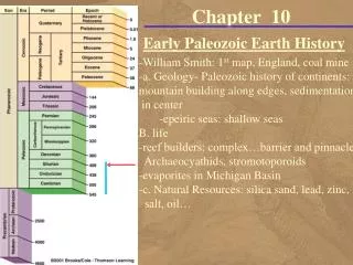
Chapter 10. Early Paleozoic Earth History. The First Geologic Map. William Smith, a canal builder, published the first geologic map on August 1, 1815. The First Geologic Map. Five of the six geologic Paleozoic systems Cambrian, Ordovician, Silurian, Devonian, and Carboniferous

E N D
Chapter 10 Early Paleozoic Earth History
The First Geologic Map • William Smith, • a canal builder, published the first geologic map • on August 1, 1815
The First Geologic Map • Five of the six geologic Paleozoic systems • Cambrian, Ordovician, Silurian, Devonian, and Carboniferous • We use the same basic geologic principles to interpret the geology of the Paleozoic Era
Cratons and Mobile Belts • Pannotia supercontinent began broke apart during the latest Proterozoic • By the beginning of the Paleozoic Era, • six major continents were present • Each continent can be divided • into two major components • a craton • and one or more mobile belts
Continental Architecture • Cratons typically consist of two parts • a shield • and a platform
Platforms • Extending outward from the shields are buried Precambrian rocks • The sediments over the platforms were deposited in widespread shallow seas
Paleozoic North America • Platform
Epeiric Seas • The transgressing and regressing shallow seas • called epeiric seas • common feature of most Paleozoic cratons
Mobile Belts • Mobile belts are elongated areas of mountain building activity • They are located along the margins of continents • where sediments are deposited in the relatively shallow waters of the continental shelf • and the deeper waters at the base of the continental slope • During plate convergence along these margins, • the sediments are deformed • and intruded by magma • creating mountain ranges
Four Mobile Belts • Four mobile belts formed • around the margin • of the North American craton during the Paleozoic • Franklin mobile belt • Cordilleran mobile belt • Ouachita mobile belt • Appalachian mobile belt
Paleozoic North America • Mobil belts
Paleogeographic Maps • Geologists use • paleoclimatic data • paleomagnetic data • paleontologic data • sedimentologic data • stratigraphic data • tectonic data • to construct paleogeographic maps • which are interpretations of the geography of an area for a particular time in the geologic past
Paleozoic paleogeography • The paleogeographic history • of the Paleozoic Era is not as precisely known • as for the Mesozoic and Cenozoic eras • in part because the magnetic anomaly patterns • preserved in the oceanic crust • was subducted during the formation of Pangaea • Paleozoic paleogeographic reconstructions • are therefore based primarily on • structural relationships • climate-sensitive sediments such as red beds, evaporates, and coals • as well as the distribution of plants and animals
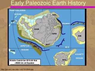
Six Major Paleozoic Continents • Baltica - Russia west of the Ural Mountains and the major part of northern Europe • China - a complex area consisting of at least three Paleozoic continents that were not widely separated and are here considered to include China, Indochina, and the Malay Peninsula • Gondwana - Africa, Antarctica, Australia, Florida, India, Madagascar, and parts of the Middle East and southern Europe
Six Major Paleozoic Continents • Kazakhstan - a triangular continent centered on Kazakhstan, but considered by some to be an extension of the Paleozoic Siberian continent • Laurentia - most of present North America, Greenland, northwestern Ireland, and Scotland • and Siberia - Russia east of the Ural Mountains and Asia north of Kazakhstan and south Mongolia
Paleogeography of the World • For the Late Cambrian Period
Paleogeography of the World • For the Late Ordovician Period
Paleogeography of the World • For the Middle Silurian Period
Early Paleozoic Global History • In contrast to today's global geography, • six major continents • dispersed at low tropical latitudes • polar regions were mostly ice free • By the Late Cambrian, • epeiric seas had covered most areas of • Laurentia, Baltica, Siberia, Kazakhstania, China,
Ordovician and Silurian Periods • Gondwana moved southward during the Ordovician and began to cross the South Pole • as indicated by Upper Ordovician tillites found today in the Sahara Desert • In contrast to Laurentia’s passive margin in the Cambrian, • an active convergent plate boundary formed along its eastern margin during the Ordovician • as indicated by the Late Ordovician Taconic orogeny that occurred in New England
Silurian Period • Baltica moved northwestward relative • to Laurentia and collided with it • to form the larger continent of Laurasia • This collision closed the northern Iapetus Ocean • Siberia and Kazakhstania moved from • a southern equatorial position during the Cambrian • to north temperate latitudes • by the end of the Silurian Period
Early Paleozoic Evolution of North America • The geologic history of the North American craton may be divide into two parts • the first dealing comings and goings of epeiric seas • the second dealing with the mobile belts In 1963, American geologist Laurence Sloss proposed that the sedimentary-rock record of North America could be subdivided into six cratonic sequences
Cratonic Sequences of N. America • That are separated by large-scale uncon-formities shown in brown • White areas represent sequences of rocks Appa-lachian oro-genies Cordilleran orogenies
Cratonic Sequence • A cratonic sequence is • a large-scale lithostratigraphic unit • greater than supergroup • representing a major transgressive-regressive cycle • bounded by craton-wide unconformities • The six unconformities extend across • the various sedimentary basins of the North American craton • and into the mobile belts along the cratonic margin
The Sauk Sequence • Rocks of the Sauk Sequence • during the Late Proterozoic-Early Ordovician • record the first major transgression onto the North American craton • Deposition of marine sediments • during the Late Proterozoic and Early Cambrian • was limited to the passive shelf areas of the • Appalachian and Cordilleran borders of the craton • The craton itself was above sea level • and experiencing extensive weathering and erosion
Cratonic Sequences of N. America • Brown areas = large-scale uncon-formities • White areas = sequences of rocks • Sauk sequence
The Sauk Sequence • Because North America was located • in a tropical climate at this time • but there is no evidence of any terrestrial vegetation, • weathering and erosion of the exposed • Precambrian basement rocks must have proceeded rapidly • During the Middle Cambrian, • the transgressive phase of the Sauk • began with epeiric seas encroaching over the craton
Transcontinental Arch • By the Late Cambrian, • the Sauk Sea had covered most of North America, • leaving above sea level only • a portion of the Canadian Shield • and a few large islands • These islands, • collectively named the Transcontinental Arch, • extended from New Mexico • to Minnesota and the Lake Superior region
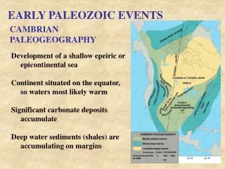
Cambrian Paleogeography of North America • During this time North America straddled the equator • Trans-continental Arch
The Sauk Sediments • The sediments deposited • on both the craton • and along the shelf area of the craton margin • show abundant evidence of shallow-water deposition • The only difference • between the shelf and craton deposits • is that the shelf deposits are thicker
Sauk Carbonates • Many of the carbonates are • bioclastic • composed of fragments of organic remains • contain stromatolites, • or have oolitic textures • contain small, spherical calcium carbonate grains • Such sedimentary structures and textures • indicate shallow-water deposition
A Transgressive Facies Model • Recall that facies are sediments • that represent a particular environment • During a transgression, the coarse (sandstone), • fine (shale) and carbonate (limestone) facies • migrate in a landward direction
Cambrian Transgression • The three formations exposed • along the Bright Angel Trail, Grand Canyon Arizona • Cambrian strata exposed in the Grand Canyon
Transgression • The Tapeats sediments • are clean, well-sorted sands • of the type one would find on a beach today • As the transgression continued into the Middle Cambrian, • muds of the Bright Angle Shale • were deposited over the older Tapeats Sandstone
Time Transgressive Formations • Faunal analysis of the Bright Angel Shale indicates • that it is Early Cambrian in age in California • and Middle Cambrian in age in the Grand Canyon region, • thus illustrating the time-transgres-sive nature of formations and facies younger shale older shale
Cambrian Transgression • Cambrian strata exposed in the Grand Canyon • Observe the time transgressive nature of the three formations • The three formations exposed • along the Bright Angel Trail, Grand Canyon Arizona
Same Facies Relationship • By the end of Sauk time, much of the craton • was submerged beneath a warm, equatorial epeiric sea
Cambrian Facies • showing 3 major Cambrian facies • and the time transgressive nature of the units • The carbonate facies developed progressively • due to submergence of the detrital source areas by the advancing Sauk Sea • Block diagram from the craton interior to the Appalachian mobile belt margin
Upper Cambrian Sandstone • Outcrop of cross-bedded Upper Cambrian sandstone in the Dells area of Wisconsin
Regression and Unconformity • During the Early Ordovician, the Sauk Sea regressed. • The rocks exposed were predominately • limestones and dolostones • that experienced deep and extensive erosion • The resulting craton-wide unconformity • marks the boundary between the Sauk • and Tippecanoe sequences
Ordovician Period • Paleo-geography of North America • showing change in the position of the the equator • The continent • was rotating counter-clockwise
Cratonic Sequences of N. America • brown areas = large-scale uncon-formities • White areas = sequences of rocks • Regression • Tippecanoe sequence
The Tippecanoe Sequence • A transgressing sea deposited the Tippecanoe sequence over most of the craton • Middle Ordovician-Early Devonian • The Tippecanoe basal rock is the St. Peter Sandstone, • an almost pure quartz sandstone • occurs throughout much of the mid-continent • resulted from numerous cycles of weathering • and erosion of Proterozoic and Cambrian sandstones • deposited during the Sauk transgression
Transgression of the Tippecanoe Sea • Resulted in the deposition of • the St. Peter Sandstone • Middle Ordovician • over a large area of the craton
St. Peter Sandstone • Outcrop of St. Peter Sandstone in Governor Dodge State Park, Wisconsin
The Tippecanoe Sequence • The Tippecanoe basal sandstones were followed by widespread carbonate deposition • The limestones were generally the result of deposition • by calcium carbonate-secreting organisms such as • corals, • brachiopods, • stromatoporoids, • and bryozoans
Tippecanoe Reefs and Evaporites • Organic reefs are limestone structures • constructed by living organisms • Reefs appear to have occupied • the same ecological niche in the geological past
Modern Reef Requirements • Present-day reefs • grow between 30 degrees N and S of equator • Reefs require • warm, clear, shallow water of normal salinity for optimal growth
Present-Day Reef Community • with reef-building organisms
Reef Environments • Block diagram of a reef showing the various environments within the reef complex