Download
1 / 32
320 likes | 488 Vues
Sediment Management for River Restoration. Tom Dunne Spring 2011. Readings for week 4. Slaymaker, O., The sediment budget as conceptual framework and management tool, Hydrobiologia , v 494, pp 71-82.

E N D
Sediment Management for River Restoration Tom Dunne Spring 2011
Readings for week 4 • Slaymaker, O., The sediment budget as conceptual framework and management tool, Hydrobiologia, v 494, pp 71-82. • Walling, D. E., The role of overbank floodplain sedimentation in catchment contaminant budgets, Hydrobiologia, v 494, pp. 83-91 • Brooks, A.P. and G. Brierley, Framing realistic river rehabilitation targets in light of altered sediment supply and transport relationships: lessons from East Gippsland, Australia, Geomorphology, v 58, pp 107–123, 2004. • Nelson, E.J. and D. B. Booth, Sediment sources in an urbanizing, mixed land-use watershed, Journal of Hydrology, 264, 51–68, 2002.
Response of river or ecosystem Response of river or ecosystem Flow Sediment supply Managing the role of sediment supply in river restoration is more difficult than managing the effects of flow
Sediment supply from the watershed is more difficult to predict than flow • Total amounts • Grain sizes – washload; bed-material load • Timing – strongly stochastic
Sediment Management • Extent and nature of sediment management depends on • the problem to be solved • whether the project is conceived as ‘river channel restoration’ or ‘watershed restoration.’ • May involve • Stabilization of sediment sources on hillslopes, etc. • Channel bank stabilization • Dredging/gravel harvest from channel • Gravel augmentation • Removal of dams and disposition of sediment (release; slurry pipe; dredge, truck and stabilize)
Analyses ‘required’ for sediment management • Stabilization of sediment sources on hillslopes, etc. • Requires sediment budget analysis for watershed and design of erosion controls • Channel bank stabilization • Geotechnical analysis of slope stability; hydraulic analysis of scour velocities, and empirical analysis of channel shifting record • Dredging or gravel harvest from channel • Modeling difficult because of highly disturbed conditions, but estimation of bed-material supply is necessary • Gravel augmentation (increasing sediment supply) • Should require transport calculation of mobile volumes and particle sizes, but rarely done. Often determined by $$$ available for purchasing gravel and activism of interest groups. • Removal of dams and disposition of sediment (release, slurry pipe, dredge and truck) • Requires extensive sediment transport modeling (Matilija dam studies)
Importance of the watershed sediment transport system • Sustainable functioning of the habitats in a river channel-floodplain depends on the functioning of the sediment transport system from the watershed through the channel reach(es) of interest • Planning and designing a restoration scheme depends on understanding and adjusting the design to this sediment transport system • Anticipation/prediction of responses of the sediment transport system is one of the most sensitive and difficult components of restoration design. • There may be harder problems, such as triggering of some biogeochemical process --- methylation of Hg or acidification of S/As bearing sediments ---, or a social process ---- failing to meet social expectations. But sediment management is the hardest one that I know anything about.
Importance of the watershed sediment transport system • Arises because the morphology and functioning of the channel/floodplain result from erosion, deposition, and transport conditions (e.g. turbidity, bed texture and mobility). • Our prediction skill is limited. • Best evidence of future states is empirical/historical, augmented by judicious use of theory and calculation. • Users must be made aware of the uncertainties in these predictions. • Made more difficult by the fact that the transport system may need to be analyzed on a range of temporal and spatial scales, e.g. • channel or dike integrity on reach length/flood event • watershed-scale and timber-harvest cycles, colonization waves, etc. • watershed scale and deglaciation history
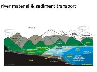
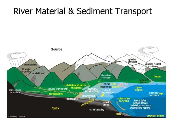
Upland zone: High sedimentsupply and low storage.Alluvial transport zone: sediment transport rate ≈ sediment supply rate. Significant transient sediment storage in valley floors and tributary fans. Multi-threaded channels in upper, steeper reaches; single-thread, meandering channels on lower gradients. ‘Free’ alluvial landforms.Alluvial accumulation zone: sediment transport capacity decreasing downstream; floodplain aggrading.Outlet: fans; deltas, estuaries. Length scale Amazon to Atascadero. Depends on plate tectonics,…. Again and always! [ESM 203]
Identification of differential transport behavior of grain size classes Bed material (sediment on channel bed/bars) Form channel features, aquatic habitat, reduce flood capacity, require dredging, etc. Total sediment supply Washload (grain sizes present in sediment supply --- e.g. soil – but not in bed material) Cause turbidity, transport contaminants, deposit downstream
Sediment Transport Mechanisms in River Channels:Washload and Bed material (≈ bedload)
Bed material is exchanged with and stored in point bars and mid-channel bars,N. Fork Snoqualmie R., WA
Washload Suspendible bed material load Bedload Selective sediment transport • Particles traced by distinctive lithology, painting, radio transmitters, magnets • Average annual transport rates: • Gravel 50 –500 m/yr • Sand 100-10,000 m/yr • Silt-clay many km, or into floodplain, where it stays for a long time
Transport mechanisms depend on grain size at a particular flow rate Washload Suspended load (DH-48) Suspended bed-material load Bed-material load Bedload (Helley-Smith) Traction bedload Transport mechanisms Definition based on measurement technologies Observable difference of transport state
Toutle River -2 and Helley-Smith bedload samplers Graham Matthews and Associates
Stochastic nature of basin-scale sediment mobilizationThe range of morphology and behavior of a river each depends on the power spectrum of sediment supply (texture and rates) and the sediment transport capacity of the reach (=f(Q,s). Benda et al., Bioscience, 2004
Supply of sediment from watershed and its storage in channel reaches are stochastic processes, modulated by drainage area for a given set of environmental conditions.Modeling of this kind is useful for making ‘qualitative’ interpretations of sedimentation risk, spatial variability of relative risk in various parts of a catchment, but not for channel design. Benda et al., Bioscience, 2004
Some tributary junctions are preferred sites of sediment accumulation and spatial and temporal habitat complexity Benda et al., Bioscience, 2004
Analyses ‘required’ for sediment management • Stabilization of sediment sources on hillslopes, etc. • Requires sediment budget analysis for watershed and design of erosion controls • Channel bank stabilization • Geotechnical analysis of slope stability; hydraulic analysis of scour velocities, and empirical analysis of channel shifting record • Dredging/gravel harvest from channel • Modeling difficult because of highly disturbed conditions, but estimation of bed-material supply is necessary • Gravel augmentation • Should require transport calculation of mobile volumes and particle sizes, but rarely done. Often determined by $$$ available for purchasing gravel and activism of interest groups. • Removal of dams and disposition of sediment (release, slurry pipe, dredge and truck) • Requires extensive sediment transport modeling (Matilija dam studies)
Dam Removal • U.S. National Inventory of Dams: 76,000 >6 ft high; ~2 million smaller structures • Peak construction 1960; > 3000 built • 748 removed so far; 306 since 1999 • 2008 --- 64; 2009 --- 58
Sometimes enormous payoffElwha Dam (30 m tall) and Glynes canyon dam upstream (70 m tall) scheduled for removal 2012 in Washington StateOpen up 110 km of prime salmon habitat Nat. Park Service
But $308 million --- $3 million/km; $100/fish (forever) For the smaller Elwha Dam the first part of the removal project is the construction of a diversion channel, which will lower the level of Lake Aldwell by 50 feet. Once the level of the reservoir is lowered in this manner, the construction team will be able to remove the Elwha Dam by controlled blasting. However, the 210-foot Glines Canyon Dam, which is double the size of the 105-foot Elwha Dam, will require additional measures to account for the larger quantities of water and sediment in Lake Mills. First, the reservoir level will gradually be drawn down using an outlet pipe to move water downstream. As the water level drops, demolition crews will cut and remove 7.5-foot sections of the dam starting from the top. These concrete blocks will be transported offsite by truck and recycled. Finally, once the sediments behind the dam are reached, controlled blasting will be used to clear the remainder of the dam. The removal strategies are designed carefully to minimize negative effects (such as flooding and decreased water quality from sediment releases), but the precautions cannot completely eliminate these effects. Most of the effects are expected to be temporary, but some infrastructure changes will need to be implemented prior to dam removal to ensure that the water supply remains safe and steady. For example, a water filtration system will be constructed down river in order to maintain the supply of water to the city of Port Angeles. Shortly after dam removal, salmon species from the Pacific Ocean will begin to recolonize gradually over 70 miles of habitat that was not accessible to spawning salmon when the dams were in place. Much of this habitat is within the bounds of Olympic National Park and is in excellent condition. It is estimated that within 30 years, the river will produce 390,000 salmon and steelhead each year. After the dams are removed, the Elwha River will regain its natural form and vast areas of land that were covered by the reservoirs will be devoid of any vegetation. These riverbank areas will be quickly planted with native plants to begin revegetation. However, it will take decades to restore portions of that land to the forested landscape that existed prior to the dams. Some immediate effects will be negative, although they are expected to be short term. For example, the sediments that were bound behind the dam will begin to migrate down river and eventually out to sea. It is expected this process will take place within 5 years. When the sediment is released initially, it may kill fish and other species in the river and decrease water quality. Additional restoration actions downstream will help to minimize the impacts from this enormous load of sediment. However, in the long term, the return of the natural flow of sediment will have many positive effects: improving spawning habitat, building up the nearshore area, and reducing the need to build up Ediz Hook artificially.
Local example, N. Fork Matilija Creek on Ventura R. Matilija Coalition
Most removal opportunities are small and ‘simple’ Clemente Dam, Carmel R. Marmot Dam, Sandy R., Oregon
Marmot Dam, Sandy R., Oregon: before, during, after.750,000 m3 of sand and gravel O’Connor et al (2008) Geotimes
Some are reeeeally complicatedKlamath – 4 private dams Ice Harbor, Lower Snake(agreement ‘reached’) --- public dam, under discussion
Matilija Dam: physical components of the plan • Sediment Management ( recent incarnation, but no final agreement yet) • Slurry Disposal - 2 million cubic yards of fine sediment downstream of Robles Diversion • Stabilize remaining 4 million cubic yards of sediment (from silt-clay to large boulders) behind the dam • Desilting basin - construct a sediment basin along the Robles Water Diversion Canal • Levees • Meiners Oaks - new levee downstream of Robles Diversion • Live Oak levee reconstruction (just upstream of Santa Ana Blvd bridge) • Bridges • Camino Cielo bridge • Santa Ana bridge • Water Supply • (Robles Diversion) Modifications - High flow bypass will flush sediment past diversion • Wells - drill 2 new water wells at Foster Park for the City of Ventura. • Arundo (giant reed) Management
At reservoir site http://www.matilijadam.org/documents/Slurry_Disposal_Studies/upstream%20storage%20011410.pps
Flood levee construction http://www.matilijadam.org/documents/Slurry_Disposal_Studies/upstream%20storage%20011410.pps
Historical channel alignments, Cottonwood Creek, CA1855-1999 Graham Matthews and Associates http://www.gmahydrology.com/services.html