Download
1 / 23
230 likes | 359 Vues
Status of New Services at the PDS Imaging Node: Atlas II, Map-a-Planet, and the Unified Planetary Coordinates Database. Lisa Gaddis (USGS) Sue LaVoie (JPL). Improved Services at the Imaging Node. Node Web site improvements Clean-up per advice from Mark Rose (Ames)

E N D
Status of New Servicesat the PDS Imaging Node:Atlas II, Map-a-Planet, and the Unified Planetary Coordinates Database Lisa Gaddis (USGS) Sue LaVoie (JPL) PDSMC March 29, 2007
Improved Services at the Imaging Node • Node Web site improvements • Clean-up per advice from Mark Rose (Ames) • New mission-specific interface • Atlas II (AKA ‘New’ Planetary Image Atlas) • Includes image data from past and current planetary missions • Improved ‘forms’ user interface allows mission-specific and multi-mission searches (e.g., for geographic searches) • Bulk-download capability added • Map-a-Planet (MAP) • New user interface provides enhanced navigation tools, etc. • Unified Planetary Coordinates (UPC) Database • Resolves issues with coordinate systems in planetary image data • Enhances usability of PDS data PDSMC March 29, 2007
Imaging Node Web Site Upgrades • Clean-up per advice from Mark Rose • Uniform look • ‘Standard’, labelled icons and buttons • Improved documentation and navigation • Node ‘Resources’ link • Search by Target or Mission • Clearly defined labels/icons for resources • New mission-specific interface guides users to • Atlas II image products and online data volumes from supported instruments • Mission science & instrument info • NSSDC collections PDSMC March 29, 2007
Atlas II and OODT • Atlas II builds on experience from the original Atlas, now has 4 distinct components: • Web Service (uses OODT) • Performs searches across all data sets within the system. System can be distributed. Intended for machine/code use. Semantics translation handled by Atlas II (e.g., East or West longitude, SCET vs FDS), then search metadata from repository’s OODT Profile Server or SQL database • User Interface (aka ‘Forms’) • The human-interface part that utilizes other access services • Data Processing • Calibration, mosaicking, geometric projection, etc. • Uses MIPL/Java Advanced Imaging (JAI) software • JPEG2000 software and server utilization • Retrieval (uses OODT) • Data download via OODT Product Server or ‘wget’ to Web Service client • Shopping-cart style bulk data ordering OODT - Object Oriented Data Technology See: http://pdsimg.jpl.nasa.gov/Missions/index.html PDSMC March 29, 2007
Atlas II Status and Plans Status: • New missions supported • Cassini and MER now operational (updated monthly) • HiRISE development version is supporting E2E Tests; operational at first delivery (June’07) enabling searches across MER & MRO HiRISE (lat/long) • Support for both mission-specific and multi-mission queries • The same code base is used for both • Common parameters of each logical grouping (data set) are dynamically found and displayed and searched across missions Plans: • System modifications • Migrate meta-data from Sybase to MySQL to increase performance • Schema optimization • Configuration file to integrate with Atlas II and OODT • Order of data migration from Atlas I web-interface to Atlas II: • FY2007: THEMIS, MGS, MEX, Galileo • FY2008: Voyager, Viking Orbiter, MPF, Clementine, Magellan PDSMC March 29, 2007
Map-A-Planet (MAP) Status • Two MAP versions currently exist: • ‘Old’ MAP at http://pdsmaps.wr.usgs.gov • New MAP at http://mapaplanet.org • ~Same content (for now) • Deliver digital image mosaics & derived products to users • Provide simple interface to other s/w (e.g., GIS applications, online data viewers, OGC WMS, ISIS) • New MAP • Enhanced user interface • Uses WMS to produce maps of spatially referenced data dynamically from geographic info in labels • Easier upload of datasets • Transition from Old to New by EOFY07 OGC WMS – Open Geospatial Consortium Web Map Service(s) PDSMC March 29, 2007
New Map-A-Planet: Interface Updates • Enhanced site navigation • Easy-to-maintain global visual style • New ‘Explorer Help’ • Navigation & display tools • Data and Image Info • ‘Data Sets’ summaries • GIS ‘world file’ output supports planetary mapping and science • Compliance with accessibility regulations and agency policies PDSMC March 29, 2007
New Map-A-Planet: Interface Updates (cont.) • Improved map navigation • Easy-to-use selection & display tools • Multiple image projections • Simple cylindrical • Mercator • Sinusoidal • Includes links to • Named features in Planetary Gazetteer (USGS nomenclature database) • Published USGS planetary maps PDSMC March 29, 2007
MAP Development Now Underway • Capability to process 32-bit data • Addition of MGS TES DATASET files • Ingest PDS detached labels • Input and Output ISIS formatted files • New data added (or soon to be added): • Icy satellites data from Voyager and/or Galileo SSI • Rhea, Dione, Tethys, Iapetus, Enceladus, Mimas • Mars MOLA (64 pixels/deg) global mosaic • Mars MOC (64 and 256 pix/deg) NA global mosaics • Mars TES global derived data (albedo, thermal inertia @ 8 pix/deg) PDSMC March 29, 2007
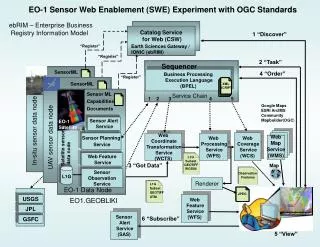
Unified Planetary Coordinate (UPC) Database • A geometry database system to ‘unify’ coordinate systems for allplanetary image data • Delivers ‘improved’ data resulting from planetary cartography work • Resolves a problem with coordinate system disparities in older planetary image data (esp. for Mars) 1996-2006 Planetographic – Angle between the equatorial plane and a line that is normal to the reference ellipsoid Planetocentric – Angle between the equatorial plane and a line from the center of the ellipsoid PDSMC March 29, 2007
Unified Planetary Coordinate (UPC) Database • Geometry database system • Ingests pointing and label info from image labels • Calculates coordinates for a given planet • Mars: ‘Ocentric, 0 to 360, pos East • Delivers ‘improved’ pointing/location data • Designed to improve data search & retrieval capability for users of PDS image data • User Interfaces and ‘Outputs’ • Mission-specific flat tables (like PDS cumindex) • Atlas II (and ODE?) DB ‘underlayer’ • Web Services interface • Output formats include IMG, CUB, JPEG2000, GIS worldfiles (for OGC WMS s/w and servers), etc. • Capable of real-time mission support in closed computing environment • Installable in remote locations to support mission operations PDSMC March 29, 2007
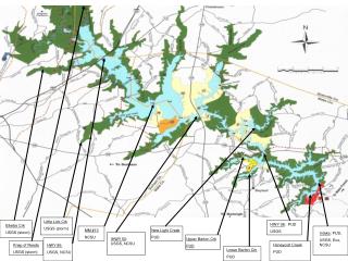
-12.5 -17.5 178.0 173.0 UPC Database (cont.) Footprints of MGS/MOC NA (green) and THEMIS/VIS (brown) images of MER Spirit landing site. Image ID constrained to incidence angles between 60º and 70º • Prototype DB system now running with >600K images from MOC, THEMIS, HiRISE • E2E capability test completed • Cross-mission geographic & image parameter search • Plotting of footprints for multi-mission searches • Conversion to uniform planetary coordinates for Mars data • MO THEMIS • MGS MOC NA • MRO HiRISE • Map projection to MOLA topographic model (DEM) of Mars • Construction of map-projected mosaics of images selected with UPC Mosaic of MOC NA and VIS images from the UPC query for the area above PDSMC March 29, 2007
UPC Database: Current Status • Basic database structure now operational for Mars and some lunar image data • Data Population Process (Mars, Moon) (EOY07+) • Now in progress • Mars data (‘ocentric, positive East, 0 to 360): • MRO HiRISE data from Release #1 (June ’07) • MGS/MOC NA and WA • MO THEMIS VIS/IR • Followed by Viking Orbiter 1 & 2 • Moon data: • Clementine data • LO, Galileo SSI and NIR, LROC to follow • Deployment (Oct to Dec ‘07) • ISIS 3 (rsync) • Web services interface • Atlas II integration • Optimization of UPC database operations & interface to continue into FY08 PDSMC March 29, 2007
Note that this is a log plot! Imaging Node and Lunar Data • Currently available data (Atlas II and/or MAP): • Galileo SSI and NIR • Clementine UVVIS (5-band cubes) • New lunar data (UPC, Atlas II, MAP) • Lunar Orbiter • Clem NIR (6-band cubes) • Clem derived (Fe, Ti, etc.) • Lunar Prospector • LRO Camera • Apollo Metric & Pan? • From international missions? PDSMC March 29, 2007
Extra Slides Follow PDSMC March 29, 2007
Atlas II User Interface PDSMC March 29, 2007
Atlas II and OODT Overview PDSMC March 29, 2007
Imaging Node Structure PDSMC March 29, 2007
Other PDS Imaging Node Updates • MRO HiRISE RDR SIS Review in progress. • Development of software to allow remote PDS validation of HiRISE data at HiRISE DN in progress. • HiRISE E2E Test 4 completed. • Last delivery of MGS MOC data on schedule for April 1, 2007. • Cassini RADAR delivery on schedule for April 1, 2007. • Odyssey THEMIS delivery on schedule for April 1, 2007. • THEMIS DN Disaster Recovery Plan Draft completed. • IN involved in testing new NSSDC data delivery interface. PDSMC March 29, 2007
Status of Atlas II (FY07) • System Development • Fully integrated MER data into Atlas II and expanded search capability • For MRO HiRISE E2E tests (1-4), developed ability to use remote profile & product servers (UofA) and allow remote update and automatic addition of released data • Web Service (using OODT) • Integrated latest OODT middleware • Added associations so that EDRS are related to RDRs and vice-versa • User Interface • Enhanced the ‘human interface’ or ‘forms-based’ data entry capability • Allows entry via mission-specific and multi-mission views • Geographic searches across missions are now possible • Processing • Preparing to expand the interface to include data processing capabilities (data calibration, mosaicking, geometric processing, etc.) • Retrieval (using OODT) • Modified data download capability for large MRO and MEX files • Added bulk-download capability via automatic generation of client-side ‘wget’ scripts See: http://pdsimg.jpl.nasa.gov/Missions/index.html PDSMC March 29, 2007
Aspects of UPC Database • Database characteristics • Applies only to images for which camera models exist in ISIS 3 • Models exist for major Mars and Moon datasets • Addition of models funded annually by PGG Carto program • Models for new instruments typically funded by mission Projects • Original SPICE data serve as starting point • Pointing/positional data for images continually updated as data are used for creation of mapping products • Map products now include projection to planetary DEMs (where available) • Delivered in ISIS3, via Web Services interface, Atlas II, ODE? • Results can be provided back to NAIF in the form of new SPICE kernels PDSMC March 29, 2007
Early Development Needed NOW for Massive Dataset Processing and Control • Significant algorithm, software, and procedure development needed for coming massive LRO and foreign mission datasets • Handling large datasets • Control of line scanner, push frame, wide field camera images • Auto tie pointing techniques • Auto outlier rejection • Large solution partitioning The LROC NA image set is~1600 timesthe size of the entire Clementine UVVIS dataset! Note that this is a log plot! PDSMC March 29, 2007
Expected Lunar Data VolumesNote: This is a log plot! PDSMC March 29, 2007