Download
1 / 29
330 likes | 479 Vues
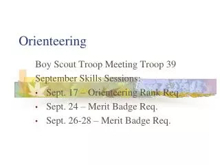
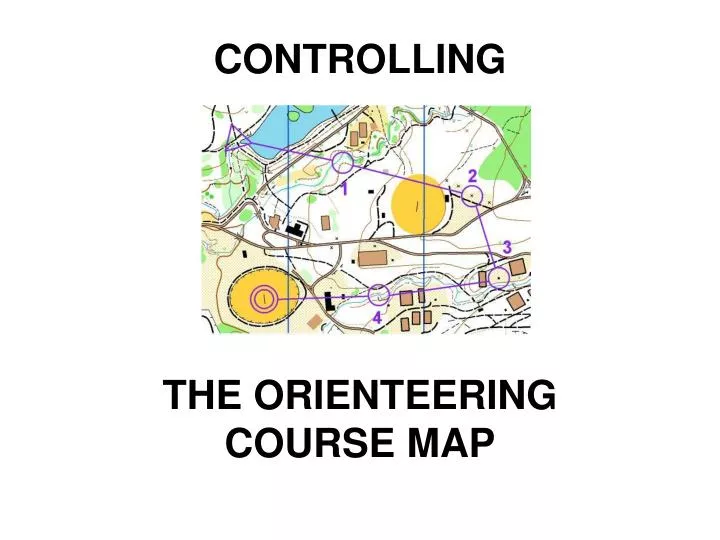
CONTROLLING THE ORIENTEERING COURSE MAP. There is a need for a stricter enforcement of the rules. An evaluation of IOF Event Maps found an increasing number of map deviations ie Non standard symbols Wrong line widths Wrong colours Non-sharp lines Overly detailed maps

E N D
There is a need for a stricter enforcement of the rules An evaluation of IOF Event Maps found an increasing number of map deviations ie Non standard symbols Wrong line widths Wrong colours Non-sharp lines Overly detailed maps Graphic minimum dimensions not respected Wrong map scales applied Wrong size of control circles Area symbols too small Poor generalisation Inferior quality paper Ref: IOF Map Commission
Is the map important?YES A standardized map is the basis for orienteering as an international event A map with deviations = unfair competition Ref: IOF Map Commission
Controller to ensure the Course Map complies with the rules • International Specification for Orienteering Maps - Foot-O Sprint (1:5000-4000) Ski-O MTBO - Check list for controlling the map making of major IOF events • IOF Control Descriptions 2004 - Course marking • Competition Rules for Orienteering Australia Foot Orienteering Events - Section 15. Maps - Section 17. Restricted areas and routes - Section 18. Control descriptions • OA Guidelines - Digital Printing Policy - Operational Manual 6.3
Requirements of an Orienteering map The map must: • give a picture of the terrain • be accurate • use IOF map symbols & scales • be legible and • be up to date
The map must be accurate absolute and relative accuracy • Absolute accuracy is out by 85-90m at control 24. Map distortions? • Relative accuracy appears OK as orienteers found the control!
The map must be accurate • Use a GPS to check map accuracy and correct location of controls • Check magnetic north declination • Check the spacing of North lines & breaks in lines
The map must useIOF map symbols & scales • an international symbol set • is a symbol set developed over many years • no deviations = fair competition • revision of ISOM 2000 to consider: • technological changes in map production • new event formats ie sprint & middle • add new, modify or delete symbols • map scale
The map must use the correct scale for the event format • Long distance 1:15000, 1:10000* with approval** for elites 1:10000* for < M/W16 and >M/W40 • Middle distance 1:15000, 1:10000* • Relay 1:15000, 1:10000* • Sprint 1: 5000 or 4000 *A 1:10000 map is a strict enlargement of a 1:15000 map **Approval is needed for M/W Elite junior & senior and M/W 17-39A in the Australian Championships to use a scale other than 1:15000
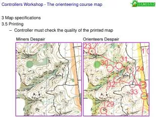
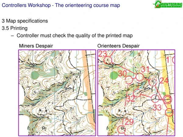
The map must be legible Legibility is dependent on: • the Quality of the Mapping • the Quality of the Printing • the Quality of the Paper
The map must be legible • the Quality of the Mapping “a few well drawn features are better than a lot of small detail that may clutter the map or disguise the shape of the landform” Eduard Imhof, Swiss cartographer
The map must be legible • the Quality of the Mapping “Maps get more and more detailed. I don’t know if this is the right way to go, but it is a fact.”Thierry Gueorgiou Dec 2007
The map must be legible • the Quality of the Mapping - What features to map – as per ISOM: min heights & areas - How the feature is to be drawn – as per ISOM: symbol size, line width
The map must be legible • the Quality of the Mapping • the Quality of the Printing • off-set spot colour printing - Is the only method approved for IOF Foot-O ranking events (2) other printing methods - ie 4 colour (CMYK) digital, digital offset (digital colour press), laser printers, inkjet printers, colour copiers - Laser printers now commonly used in Australia - Print quality is highly variable
The map must be legible • the Quality of the Mapping • the Quality of the Printing - For Level A events: digital printing is OK if there is no significant loss of line quality, legibility, colour appearance and map durability OA Digital Printing Policy Operational Manual 6.3 - 1:10000 maps more likely to be suitable for digital printing
The map must be legible • the Quality of the Mapping • the Quality of the Printing • the Quality of the Paper Legibility factors to consider: • bright white paper (not off-white) for best colour contrast • matt finish (not glossy or shiny) Related factors • texture or ‘feel’ of the paper, ‘foldability’ • paper thickness / weight • durability of paper in all conditions • water resistance of paper, need for a plastic bag (0.10mm) • waterproof paper
An example – legibility of contours • Difficult to calibrate dot size in some digital printers • Cartography may need to reflect printing method and paper quality • Use the same print setting for all maps used at an event
The map must be up to date • Changes to the extent and density of vegetation • Impact of fire, flooding & erosion • Sprint maps need constant review • Seasonal changes • New tracks, roads, man made features • ……..
Quality control toolsfor use by the Controller and Planner • OA colour swatch • OA colour purple swatch • IOF Map Commission Print Tech Project ‘test sheet’
Quality control tools • OA colour swatch Check colours on a map by comparing to the OA off-set spot colour swatch
Quality control tools • OA colour purple swatch CMYK 43 91 00 00 CMYK 30 100 15 00 Now recommended
Quality control tools • IOF Map Commission Print Tech Project ‘test sheet’ template Compare a digital test print with the IOF off-set spot colour ‘test sheet’ Check for: Sharp edges to lines and symbols Correct colours Even colours No stripes, holes, bubbles Resolution - clear thin lines, no moire effect, no zig zag edges Vertical & horizontal accuracy Do contour lines have the same appearance over the colour screens nb brown is often a problem over mid & dark green And more……..
Some recent map deviations in Australia • Non standard symbols used for horse jumps ie elongated “H” or box • - use fence symbol • Colours not adjusted for printer • – a common problem when using 4 colour Laser printers • Fuzzy lines • – use a better printer! • Sprint map scale of 1:3000 • - must be 1:4000 or 1:5000 • Vegetation area symbols too small for legibility • - leave off map or redraw with respect to minimum dimensions • Map scale of 1:10000 with 1:15000 map symbols • - a 1:10000 map must be a strict enlargement of a 1:15000 map • Man made features when used not defined • - the legend or map notes must describe the feature ie pole • Can not incorporate ISOM fence symbols with Sprint maps • - Sprint only have two: Passable & Impassable
Course marking considerations • Circle size, line width and text may be 150% for an enlarged map - otherwise may need to change the control descriptions • Do not cover important map detail - use overprinting effect or cut out line segments
Course marking considerations • Can only use control features that are obvious in the field and accurately shown on the map. • Dangerous objects and areas to be marked on the map and flagged in the field • Controller and Course setter should use the same software • Map: OCAD • Course: OCAD, Condes, Corpse • Have a system to track updates, corrections, changes
Using map subsets Subset (and all maps) to have a • Title • Scale ratio (Bar scale highly recommended) • Contour interval • North lines • Correct spacing of N lines • 1:15000 - 500m • 1;10000 - 250m • 1:4000 & 1:5000 -150m • Legend, or if insufficient space print as a separate sheet • Date of mapping, with updates • Credits: mapper, map owner, land holder • Notes on Special symbol(s) if used
Using map subsets Some more considerations: • Ensure sufficient space between the map edge and controls or likely route choices • Avoid covering part of the legend with the control description • Keep the number of map subsets to a minimum • easier to manage, less chance of mistakes • Map subset should fit an A4 or A3 page • note: 1:15000/A4 will fit on to an 1:10000/A3
What is your decision as controller? Should a Sprint map be used for a Middle Distance event? On the Sprint map below are competitors allowed to cross the Impassable wall on leg 19 to 20? Competitor safety?