Download
1 / 52
520 likes | 523 Vues
Explore how maps provide a point of view in understanding history and the biases that come with it. Discover the political, economic, and cultural perspectives that influence map projections.

E N D
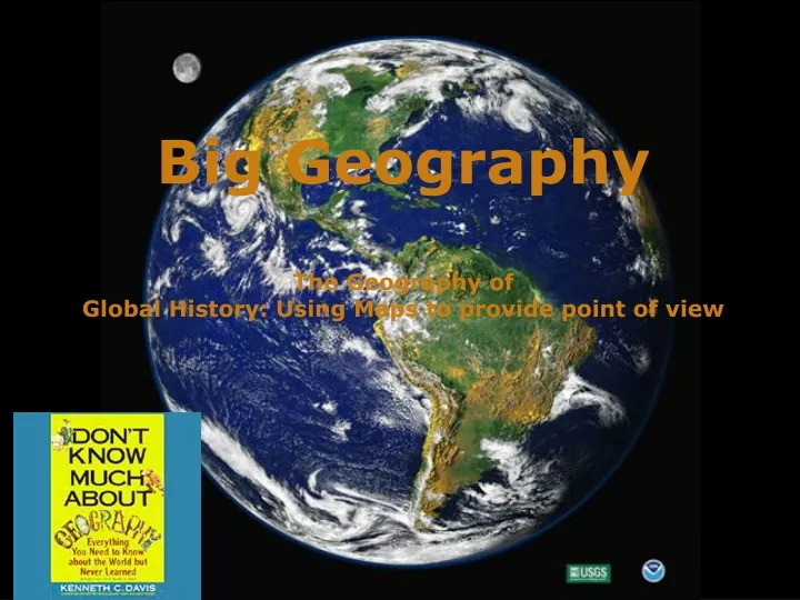
Big Geography The Geography of Global History: Using Maps to provide point of view
Point of View through Maps Maps are a conceptual way to determine bias and point of view. Often They provide a framework to determine the author’s (cartographer’s) Perspective of the world they live in. There are broad political, economic, and Cultural perspectives (thesis?) which guide their point of view (POV) and are Skewed by their limited and/or narrow perspectives. An example would be the Traditional Mercator projection map utilized in millions of classrooms which Was developed in the 16th century by Gerhardus Mercator for European navigators During the Age of exploration. Europe is clearly in the center and the shape and Sized of the continents are distorted to reflect a Eurocentric bias.
Which map projection does the College Board use in their WHAP materials?
History-Culture-Location • North America • Latin America • West Europe • East Europe • East Asia • Central Asia • South/South East Asia • Middle East • Sub-Saharan Africa
Political- Economic-Geographic • East Asia- isolated by Gobi, Himalaya and Pacific • South Asia- sub-continent along Indian ocean( monsoon winds) centrally located • Latin America- because of European imperialism and culture diffused ( language and religion) • West and East Europe- divide politically and culturally after the fall of Rome ( later Communism became important between East and West) • Central Asia- the traditional area of the nomadic steppe peoples ( Turks, Huns, Mongols, etc.) • Sub-Saharan Africa- connected through trans- Sahara trade, isolated by desert for many years • Middle East- ethnocentric designation (U.S) also called South West Asia, noted by trade, civilization and religion (90% Muslim) • North America- politically and culturally different than Latin America by Northern European colonization and identified by Canada, the U..S and Mexico which is also part of Latin America • Maps help historians conceptualize world history by identifying the ethnocentric bias of regions based on political perspective (Middle East), evaluation the economic resources of the region and their value (South Asia) and by identifying the dominant cultural traits of language and religion of the territory (Latin America)
We need a mental picture of the whole world, not just certain parts of it. This is “big geography.” What are some of the issues concerning geography?
The perception Of the world can be Ethnocentirc? Africa U S A. South America
The Earth is a sphere. Therefore, it cannot be projected on a flat map without distortion. The question is, which kind of distortion?
Medieval European T-O Map. In medieval Europe one of the most common forms of rendering the earth was the mappae mundi of which more than a thousand have survived. The T-O map is one kind of mappae mundi. The T-O image reproduced here comes from the encyclopedia of knowledge produced by Isidore, Bishop of Seville, in 630 A.D., and was printed in Augsburg in 1472.
An ancient map that strongly suggests Chinese sailors were first to round the world. It seems more likely that the world and all its continents were discovered by a Chinese admiral named Zheng He, whose fleets roamed the oceans between 1405 and 1435. His exploits, which are well documented in Chinese historical records, were written about in a book which appeared in China around 1418 called "The Marvellous Visions of the Star Raft". One of Zheng He's fleet's adventures, blown off course to the east to the New World, provides a fascinating thread in Neil Stephenson's fabulous fiction, Cryptonomicon. It is a copy, made in 1763, of a map, dated 1418, which contains notes that substantially match the descriptions in the book . Each fleet would have at least one "Treasure ship", used by the commander of the fleet and his deputies (nine-masted, about 120 meters (400 ft) long and 50 m (160 ft) wide).
North America appears to be more involved in the Pacific Basin than South America (its eastward location pulling it toward the Atlantic). Finally, this map reveals a major truth about the earth, and that is that the earth is mostly water not land, the Pacific Ocean amounting to 64,000,000 square miles (over twice the size of the Atlantic Ocean).
Miller World Map Centered on 180 Meridian: The Pacific Perspective. South is at top of map. After 1850, a Pacific perspective must be added. With the United States acquiring Alaska, the Aleutian Islands, and Hawaii (and taking possession of the Philippines), followed by Pearl Harbor and the Pacific theater of World War II, the strategic importance of the Pacific for the United States becomes obvious. With China emerging as a major power, the twenty-first century may become the Pacific century.
The Maya Cosmos. Adopted with modifications from Linda Schele and David Freidel, A Forest of Kings: The Untold Story of the Ancient Maya (N.Y.: William Morrow, 1990), p. 67, fig. 2:1. Drawing by Linda Schele, courtesy Foundation for the Advancement of Mesoamerican Studies, Inc. (permissions Nov. 7, 2002).
On a Mercator projection, invented by Gerardus Mercator in 1569, any straight line is a line of constant compass bearing. This enables a navigator to plot a straight-line course.
Despite the values of the Mercator Projection, it distorts the size and shape of land areas. Fact: South America is 8 times as large as Greenland. Fact: Africa is 14 times as large as Greenland. The Peters Projection is an “equal area” map. It represents areas accurately, but it seriously distorts shapes. Compare the size of Europe to Africa on the two maps. Compare the size of the former USSR to China on the two maps.
Most Populous Nations • Population Map of the world
Gross Domestic Product • Measure of a countries wealth
Thesis • Mapping projections provide perspectives and biases in world history through a political framework like the Mercator projection map illustrating a Eurocentric perspective of the world (distorting size), economically identifying that land mass is far more important than maps about energy consumption or population density and culturally illustrating the limitations of human knowledge such as the Medieval European T-O map based upon biblical interpretations of the Earth. Mapping is a way to view point of view and perspective in world history through the Miller world map providing a focus on the Southern Hemisphere on top and a Pacific focus and the political cartoon illustrating the ethnocentric American view illustrating a much larger U.S an minimal other regions. Visual perspectives of geography give world historians an opportunity to view geography from the cartography where energy consumption in the important comparative, Peter’s projection maps illustrating a more equal area status ( South America being 8 times larger than Greenland), and the WHAP regional breakdown where regions are united by a common geography,history or cultural connection
Visual perspectives of geography give world historians an opportunity to view geography from the cartography where energy consumption in the important comparative, Peter’s projection maps illustrating a more equal area status ( South America being 8 times larger than Greenland), and the WHAP regional breakdown where regions are united by a common geography,history or cultural connection
Human beings inhabit the biosphere. The biosphere is made up of three layers. • The lithosphere: The solid earth, or outer crust of rock, sand, and soil. • The hydrosphere: The watery realm. About 97 percent of it is the oceans. • The atmosphere: The thin layer of gasses, mainly nitrogen and oxygen. How can this be illustrated on a map?
The lithosphere is in constant, though slow motion. The surface of the earth and the location of its land masses have therefore had a continuously changing history.
The scene of history is continuously moving land masses.Notice in the left column the names of distinct land masses that no longer exist.The red dot represents the location of the Grand Canyon. India 550 Million Years Ago 130 Million Years Ago Pangaea South America 220 Million Years Ago 65 Million Years Ago Laurasia Gondwanaland Today 190 Million Years Ago
70.9 % of the surface of the earth is water. Human beings, however, are a land-dwelling species. We call the biggest land areas continents.
How many continents are there? Nine? One? Seven? Five? Four?
But what IS a continent? The conventional map of seven continents
Conventional definition of a continentA large mass of land surrounded, or nearly surrounded, by water. If that is the conventional definition, why are Europe and Asia separate continents?
Since the nineteenth century, most scholars have accepted the Ural Mountains as part of the dividing Line between “Europe” and “Asia” as continents. The Urals as a border between continents? They are not that impressive.
Ural Mts. EUROPE ASIA Another part of the dividing line: Bosporus and Dardanelles (Straits)
Istanbul Bosporus Dardanelles
What significance have the Bosporus and Dardanelles had as a line dividing peoples from one another in history? Almost none!
The Ottoman Turkish Empire about 1550. Its territory cut straight across the Bosporus and Dardanelles. So is geography about What divides us or Unifies us?
Here’s a highway bridge across the Bosporus. Today, you can drive from “Asia” to “Europe” in a few minutes. Wow, its like across to continents… Or just one!!!!
So, why is Europe a continent? European scholars of the nineteenth century decided that it should be one. One of the benefits of having power in the world is that you get to name things!
The dividing line between “Europe” and “Asia” is not something that is “natural.” That is, it does not exist as a fact of the natural world. Many geographers have therefore been willing to unite the two regions as a single continent called “Eurasia.”
Asia + Europe = Eurasia E U R A S I A
But is Africa separated from Eurasia by a wide ocean? No! Why not think of Eurasia and Africa together as a single “supercontinent?” Let’s call it “Afroeurasia.”
Africa + Asia + Europe = Afroeurasia A F R O E U R A S I A
So what’s an Ocean and How many are there? Some say 4, others say 5… why? Perceptions are constantly changing
The major winds and currents of the oceansUntil the coming of steamships in the 19th century, sailors had to know winds and currents to have confidence that they could sail from one place to another in an approximate amount of time. These winds and currents follow large global patterns. It was a matter of discovering what those patterns were. winter summer Indian Ocean Monsoon Winds A Might wind, is it important to illustrate winds and currents? Why?
The wind cycle in the North Atlantic helped Christopher Columbus sail both ways across the ocean. WIND WIND
So, how many continents? • Afroeurasia • Australia • Americas • Antarctica • Afroeurasia • Australia • North America • South America • Antarctica But is it possible to think of North and South America as ONE continent?