Download
1 / 8
80 likes | 147 Vues
Critical Zone Observatory Data Discovery. Each CZO maintains its own data management system(s) using the data formats it prefers

E N D
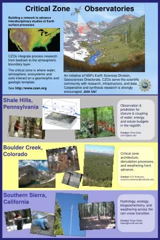
Critical Zone Observatory Data Discovery • Each CZO maintains its own data management system(s) using the data formats it prefers • The three CZO’s have a common metadata management system, expressed in tables, where each table record describes a particular data series or dataset, including its URL address • CZO Metadata tables are published and accessed through the internet using Web Feature Services (WFS) defined by the Open Geospatial Consortium • Metadata table records are linked to geographic features, also published as Web Feature Services to show data location on a base map
CZO Metadata Catalog Server A metadata catalog server is a device (e.g. ArcGIS Server, Minnesota Map Server), which can publish CZO metadata in OGC web services format Shale Hills Metadata Server Sierra Nevada Metadata Server Boulder Creek Metadata Server Metadata Catalog Services already exist for point observations time series at the Waters Network Testbed projects
CZO Data Types • Regular Time Series – data measured with automated sensors at a fixed location at regular intervals • Irregular Time Series – manually collected field samples from a fixed location at irregular intervals • GIScoverages and photos • One-Time Collections – rock and soil samples collected once at known position and depth • Other Data – LIDAR, land surveys, channel cross-sections, tree surveys, geophysics, snow surveys Point Observations Time Series
Shale Hills CZO Point Observations Susquehanna – Upper Juniata River Basin Net Radiation (W/m2) Click on the URL retrieves the data file Metadata table for Point Observations Time Series PI: Chris Duffy, Sue Brantley, Pat Reed, Henry Lin, ….
Observations Catalog for Waters Network Testbed Project in Corpus Christi Bay http://129.116.104.172/ArcGIS/services/CCBAY_MySelect/GeoDataServer/WFSServer displayed over the US Hydrology Base Map from http://downloads2.esri.com/resources/arcgisdesktop/maps/us_hydrology.mxd The same metadata structure supports data access through WaterML WSDL address and parameters to obtain observations data using GetValues Metadata for selected data series at observation point H1
Data Access from the CZEN Portal Metadata is transmitted in Geographic Markup Language Shale Hills Metadata Server http://www.czen.org/ Sierra Nevada Metadata Server Boulder Creek Metadata Server Data Behind the CZEN portal is a Master Metadata Catalog that is compiled from the CZO metadata services. The Master Catalog supports seamless data searches across the CZO network
HIS Desktop (to be developed in 2009)Harvesting data from web services Observations GIS Models Climate Remote Sensing HIS Desktop can be rebranded to become CZO Desktop if necessary
Data Access from CZO Desktop Shale Hills Metadata Server Sierra Nevada Metadata Server Boulder Creek Metadata Server Each CZO metadata catalog service and thus the CZO data is directly accessible to anyone using CZO Desktop