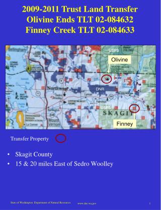
Download
1 / 19
210 likes | 570 Vues
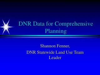
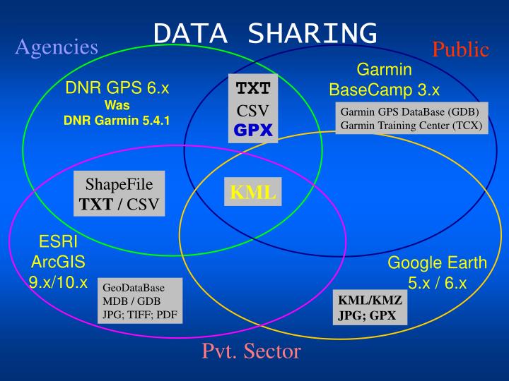
DATA SHARING. Agencies. Public. Garmin BaseCamp 3.x. TXT CSV GPX. DNR GPS 6.x Was DNR Garmin 5.4.1. Garmin GPS DataBase (GDB) Garmin Training Center (TCX). ShapeFile TXT / CSV. KML. ESRI ArcGIS 9.x/10.x. Google Earth 5.x / 6.x. GeoDataBase MDB / GDB JPG; TIFF; PDF. KML/KMZ

E N D
DATA SHARING Agencies Public Garmin BaseCamp 3.x TXT CSV GPX DNR GPS 6.x Was DNR Garmin 5.4.1 Garmin GPS DataBase (GDB) Garmin Training Center (TCX) ShapeFile TXT / CSV KML ESRI ArcGIS 9.x/10.x Google Earth 5.x / 6.x GeoDataBase MDB / GDB JPG; TIFF; PDF KML/KMZ JPG; GPX Pvt. Sector
Saving Data as KML or GPX File National Wildfire Coordinating Group– Used by Permission
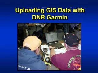
Objectives Using DNR Garmin: Save data as KML file (Google) Save data as GPX file (GPS eXchange format)
Goal: Save as KML File File was written successfully to C: \ 2006_Restoration \ incident data \ 20060328 \ gps \ 20060328_1300_restoration_waypts_femo_pt_u16n83.kml
X Select Waypoint Download Download – transfers a copy of data, does not remove data from receiver verify Coordinate System
X View Waypoint Data Table show/hide data table resize window scrollbar
X Select Files and... highlight all records to be saved verify all records selected Saving Strategy All rows highlighted – all rows saved No rows highlighted – all rows saved Some rows highlighted – those rows saved
...Save... If Google Earth is open, it will be enabled. File will save in .kml format and loads directly into My Places.
Status Window File was written successfully to C: \ 2006_Restoration \ incident data \ 20060328 \ gps \ 20060328_1300_restoration_waypts_femo_pt_u16n83.kml
Double-Click on KML File Note file path
View file in Google Earth! Each pin marks location of waypoint
Goal: Save as GPX File File was written successfully to C: \ 2006_Restoration \ incident data \ 20060328 \ gps \ 20060328_1300_restoration_waypts_femo_pt_u16n83.gpx
Status Window Note file path File was written successfully to C: \ 2006_Restoration \ incident data \ 20060328 \ gps \ 20060328_1300_restoration_waypts_femo_pt_u16n83.gpx
Using GPX Files GPX files are used in many mapping programs like National Geographic TOPO! software
View GPX Files in TOPO! GPX is a XML data format for the interchange to a variety of map applications and Web services.
SourceNational Wildfire Coordinating Grouphttp://www.nwcg.gov/ Acknowledgment Kathie Hansen (faculty chair) Regional Fire GIS Specialist, National Park Service, Midwest Region (920) 866-1767, (402) 250-8176 Cell, kathie_hansen@nps.gov Survey & Mapping-2000