Download
1 / 50
500 likes | 507 Vues
ASOS is a high-quality and well-maintained automated surface observing system located at primary and secondary airports. It is sponsored by the FAA and NWS and provides data in METAR format. The system includes various instruments such as hydrothermograph precipitation gauges, laser weather identifier, anemometer, wind vane, and laser ceilometer. It also features a freezing rain sensor, lightning sensor, visibility sensor, and more.

E N D
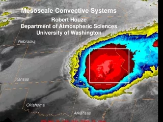
ASOS: Automated Surface Observing System: Backbone Observing System in the U.S.
ASOS • Located at primary and secondary airports • Sponsored by the FAA and NWS • High quality instrumentation that is well maintained and calibrated. • Reported in METAR format (more later)
Laser Weather Identifier
Anemometer Wind Vane Laser Ceilometer
The ASOS Freezing Rain Sensor uses an ultrasonically vibrating probe to detect the presence of icing conditions. The vibrating frequency of the probe decreases with the accumulation of ice.
Lightning Sensor Visibility Sensor
Observing Heights (ASOS and most official obs) • Temperature and dewpoint (2-m) • Wind speed and direction (10-m)
Other Surface Networks • Bureau of Land Management • RAWS • Agrimet • PAWS • Department of Ecology • Puget Sound Clean Air • BC Hydro • BC Olympics • WeatherUnderground
Networks of Networks UW: We collect data from about 60 networks in real time over NW Mesowest: Collects about 100 networks over the western third of U.S.
NWNet: Regional Real-Time Collection of Over 60 Networks Over the Pacific Northwest
Ocean and Lake Weather Buoys Anchored
Drifting Buoys Pressure Wind
Ship Reports: Marine VOS Program Volunteers Observers--generally 6-hourly reports
Satellite Microwave Scatterometer Winds
QuickScat Satellite Bounces microwaves off the ocean surface Capillary waves dependent on wind speed and directon
Radar Wind Profiler and RASS (Radio Acoustic Sounding System)
ACARS: Aircraft Observations Generally on wide-body aircraft Aircraft Communications Addressing and ReportingSystem
Cloud and Water Vapor Track Winds Based on Geostationary Weather Satellites
Radar and Satellite Imagery MORE LATER!
GPS Sounding • A constellation of GPS satellites orbit the earth. • By measuring the delay in time as the GPS signal is bent by the earth’s atmosphere, one can acquire density information that can be used to create temperature and humidity soundings. • Can do this with fixed receivers on earth or with receivers on satellites--the COSMIC project.
Typical Observation Errors at the Surface • Sea Level Pressure • Low-Elevation land stations +-.5 mb • Ships +- 1-5 mb • Temperature: +-1C • Wind Speed: +-2-5 knots, very poor for speeds below 2-3 knots. • Relative Humidity: +-10%
Radiosonde Errors • Geopotential heights: • 700 mb (hPa): 5-10 m • 500 mb 10-15 m • 300 mb 15-20 m • 100 mb 20-30 m • Temperature: +-0.5C • Wind speed: +-5%,+-10 degrees