Download
1 / 23
230 likes | 245 Vues
Change Detection on Point Cloud Data Acquired with a Ground Laser Scanner. D. Girardeau-Montaut 1,2 , M. Roux 1 , R. Marc 2 , G. Thibault 2 1 Telecom Paris 2 Eléctricité de France R&D. Contents of presentation. Goals Constraints Comparison process distance computation sampling correction

E N D
Change Detection on Point Cloud Data Acquired with a Ground Laser Scanner D. Girardeau-Montaut1,2, M. Roux1, R. Marc2, G. Thibault2 1 Telecom Paris2 Eléctricité de France R&D ISPRS workshop Laser Scanning 2005 - Enschede, the Netherlands - September 12-14
Contents of presentation • Goals • Constraints • Comparison process • distance computation • sampling correction • visibility management • Conclusion & future work D. Girardeau-Montaut, M.Roux, R. Marc, G. Thibault
Goals • Geometry comparison between two epochs day 1 day 2 day 3 day 4 D. Girardeau-Montaut, M.Roux, R. Marc, G. Thibault
Goals • … or between two states D. Girardeau-Montaut, M.Roux, R. Marc, G. Thibault
Constraints In both cases : • millions of points (up to 30M) • very partial coverage of objects • different points of view (P.O.V.) + important time constraints D. Girardeau-Montaut, M.Roux, R. Marc, G. Thibault
Common comparison technique • Cloud-to-model comparison [Cignoni et al. 1998] • fast & simple (only point-triangle distances) comparison timing : 25,4 s. (3 millions points / 13800 triangles) • Can always be used: • two models sampling points on one of them • two clouds meshing at least one of them D. Girardeau-Montaut, M.Roux, R. Marc, G. Thibault
Our case We work only with ground based LiDAR data. in order to use the common technique we should model at least one of the point cloud ! Several (big) issues: • memory usage • hazardous results if done automatically • very slow D. Girardeau-Montaut, M.Roux, R. Marc, G. Thibault
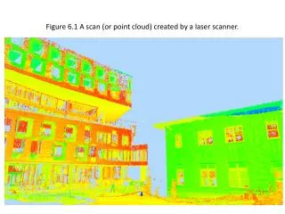
Our idea • to compare point clouds directly We use a local distance between clouds: S S’ « nearest neighbour » distance ~ Hausdorff distance D. Girardeau-Montaut, M.Roux, R. Marc, G. Thibault
Octree structure Hausdorff distance complexity: ~O(N2) Octree: recursive subdivision of space (in 8 cubes) • Comparing to a mesh : • much faster construction • less memory space used • but a slower neighbourhood extraction speed • no surface no normals D. Girardeau-Montaut, M.Roux, R. Marc, G. Thibault
Hausdorff distance computation • With octree: almost linear Test on two scans of a house mockup: 2 clouds, 650 000 points each distance computation : 2,4 s. D. Girardeau-Montaut, M.Roux, R. Marc, G. Thibault
Hausdorff distance problems Several problems: • dependant on point sampling • always associate a point with another while it not always a « good idea » … D. Girardeau-Montaut, M.Roux, R. Marc, G. Thibault
Point sampling correction 2 to 5 times slower D. Girardeau-Montaut, M.Roux, R. Marc, G. Thibault
Points visibility problem S1 T1 A B C S2 T2 distance (S2/S1) Comparison x real « change » area hidden area at T1(high distances, but no change) D. Girardeau-Montaut, M.Roux, R. Marc, G. Thibault
Field example day 1 day 2 / day 1 day 2 D. Girardeau-Montaut, M.Roux, R. Marc, G. Thibault
Y x Filtering with depth maps equivalent to a common 3D graphicalstructure named« Z-Buffer » D. Girardeau-Montaut, M.Roux, R. Marc, G. Thibault
Using depth maps to determine points visibility DM P=(P,P,Pz) If P DM P is out of f.o.v. If P DM Pz < DM(P,P) P is visible P is invisible Pz DM(P,P) Pz > scanner range P is out of range D. Girardeau-Montaut, M.Roux, R. Marc, G. Thibault
Filtering operation result day 1 day 2 simple Hausdorff distances filtered distances D. Girardeau-Montaut, M.Roux, R. Marc, G. Thibault
Multiple P.O.V. case D. Girardeau-Montaut, M.Roux, R. Marc, G. Thibault
Over-filtering issue well filtered area: lack of information in the other cloud (no change) over-filtered area (true change) we have to use recovering strategies for over filtered areas D. Girardeau-Montaut, M.Roux, R. Marc, G. Thibault
Segmentation • 3D C.C. extraction (octree ~ 3D grid) • still a manual process (distance threshold) comparison with database objects, other subsets of points, etc. D. Girardeau-Montaut, M.Roux, R. Marc, G. Thibault
Conclusion & perspectives • Dense lidar point clouds can be used efficiently “as is” for direct comparison • The whole comparison process presented here is fast and accurate But it could be faster and easier : • the segmentation process should be automatic (work in progress) • the software could be linked directly with the sensor D. Girardeau-Montaut, M.Roux, R. Marc, G. Thibault
Questions ? D. Girardeau-Montaut, M.Roux, R. Marc, G. Thibault