Download
1 / 42
420 likes | 429 Vues
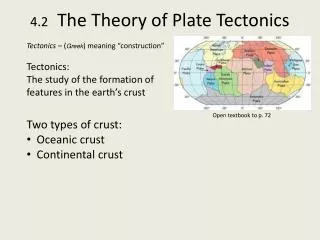
Geology 101 Chapter 2. Plate Tectonics: A Unifying Theory. Unifying Theory. A unifying theory is one that helps explain a broad range of diverse observations interpret many aspects of a science on a grand scale and relate many seemingly unrelated phenomena

E N D
Geology 101Chapter 2 Plate Tectonics: A Unifying Theory
Unifying Theory • A unifying theory is one that helps • explain a broad range of diverse observations • interpret many aspects of a science on a grand scale • and relate many seemingly unrelated phenomena • Plate tectonics is a unifying theory for geology.
Plate Tectonics • Plate tectonics helps to explain • earthquakes • volcanic eruptions • formation of mountains • location of continents • location of ocean basins • Tectonic interactions affect • atmospheric and oceanic circulation and climate • geographic distribution, • evolution and extinction of organisms • distribution and formation of resources
Early Ideas about Continental Drift • Edward Suess • Austrian, late 1800s • noted similarities between • the Late Paleozoic plant fossils • Glossopterisflora • and evidence for glaciation • in rock sequences of • India • Australia • South Africa • South America • He proposed the name Gondwanaland (or Gondwana) • for a supercontinent • composed of these continents
Early Ideas about Continental Drift • Frank Taylor(American, 1910) • presented a hypothesis of continental drift with these features: • lateral movement of continents formed mountain ranges • a continent broke apart at the Mid-Atlantic Ridge to form the Atlantic Ocean • supposedly, tidal forces pulled formerly polar continents toward the equator, • when Earth captured the Moon about 100 million years ago
Alfred Wegener and the Continental Drift Hypothesis • German meteorologist • Credited with hypothesis of continental drift-1912 in a scientific presentation – published a book in 1915.
Alfred Wegener and the Continental Drift Hypothesis • He proposed that all landmasses • were originally united into a supercontinent • he named Pangaeafrom the Greek meaning “all land” • He presented a series of maps • showing the breakup of Pangaea • He amassed a tremendous amount of geologic, paleontologic, and climatologic evidence
Wegener’s Evidence • Shorelines of continents fit together • matching marine, nonmarine • and glacial rock sequences • from Pennsylvanian to Jurassic age • for all five Gondwana continents • including Antarctica • Mountain ranges and glacial deposits • match up when continents are united • into a single landmass
Jigsaw-Puzzle Fit of Continents • Continental Fit
Jigsaw-Puzzle Fit of Continents • Matching glacial evidence • Matching mountain ranges
The Perceived Problem with Continental Drift • Most geologists did not accept the idea of moving continents • There was no suitable mechanism to explain • how continents could move over Earth’s surface • Interest in continental drift only revived when • new evidence from studies of Earth’s magnetic field • and oceanographic research • showed that the ocean basins were geologically young features
Atlantic Ocean Basin Mid-Atlantic Ridge
Seafloor Spreading • Harry Hess, in 1962, proposed the theory of seafloor spreading: • Continents and oceanic crust move together • Seafloor separates at oceanic ridges • where new crust forms from upwelling and cooling magma, and • the new crust moves laterally away from the ridge • The mechanism that drives seafloor spreading was thermal convection cells in the mantle • hot magma rises from mantle to form new crust • cold crust subducts into the mantle at oceanic trenches, where it is heated and recycled
Oceanic Crust Is Young • Seafloor spreading theory indicates that • oceanic crust is geologically young because • it forms during spreading • and is destroyed during subduction • Radiometric dating confirms • the oldest oceanic crust • is less than 180 million years old • whereas oldest continental crust • is 3.96 billion yeas old
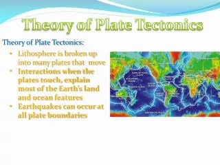
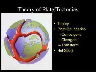
Plate Tectonics • Plate tectonic theory is based on the simple model that • the lithosphere is rigid • it consists of oceanic and continental crust with upper mantle • it consists of variable-sized pieces called plates • with plate regions containing continental crust • up to 250 km thick • and plate regions containing oceanic crust • up to 100 km thick
Plate Map • Numbers represent average rates of relative movement, cm/yr
Plate Tectonics and Boundaries • The lithospheric plates overlie hotter and weaker semiplastic asthenosphere • Movement of the plates • results from some type of heat-transfer system within the asthenosphere • As plates move over the asthenosphere • they separate, mostly at oceanic ridges • they collide, in areas such as oceanic trenches • where they may be subducted back into the mantle
Divergent Boundaries • Divergent plate boundaries • or spreading ridges, occur • where plates are separating • and new oceanic lithosphere is forming. • Crust is extended • thinned and fractured • The magma • originates from partial melting of the mantle • is basaltic • intrudes into vertical fractures to form dikes • or is extruded as lava flows
Divergent Boundaries • Successive injections of magma • cool and solidify • form new oceanic crust • Divergent boundaries most commonly • occur along the crests of oceanic ridges • such as the Mid-Atlantic Ridge • Ridges have • rugged topography resulting from displacement of rocks along large fractures • shallow earthquakes
Divergent Boundaries • Ridges also have • high heat flow • and basaltic flows or pillow lavas • Pillow lavas have • a distinctive bulbous shape resulting from underwater eruptions
Divergent Boundaries • Divergent boundaries are also present • under continents during the early stages • of continental breakup • Beneath a continent, • magma wells up, and • the crust is initially • elevated, • stretched • and thinned
Rift Valley • The stretching produces fractures and rift valleys. • During this stage, • magma typically • intrudes into the fractures • and flows onto the valley floor • Example: East African Rift Valley
Narrow Sea • As spreading proceeds, some rift valleys • will continue to lengthen and deepen until • the continental crust eventually breaks • a narrow linear sea is formed, • separating two continental blocks • Examples: • Red Sea • Gulf of California
Modern Divergence • View looking down the Great Rift Valley of Africa. • Little Magadi soda lake
Ocean • As a newly created narrow sea • continues to spread, • it may eventually become • an expansive ocean basin • such as the Atlantic Ocean basin is today, • separating North and South America • from Europe and Africa • by thousands of kilometers
Atlantic Ocean Basin Europe Africa North America South America Thousands of kilometers Atlantic Ocean basin
Convergent Boundaries • Older crust must be destroyed • at convergent boundaries • so that Earth’s surface area remains the same • Where two plates collide, • subduction occurs • when an oceanic plate • descends beneath the margin of another plate • The subducting plate • moves into the asthenosphere • is heated • and eventually incorporated into the mantle
Convergent Boundaries • Convergent boundaries are characterized by • deformation • volcanism • mountain building • metamorphism • earthquake activity • valuable mineral deposits • Convergent boundaries are of three types: • oceanic-oceanic • oceanic-continental • continental-continental
Oceanic-Oceanic Boundary • When two oceanic plates converge, • one is subducted beneath the other • along an oceanic-oceanic plate boundary • forming an oceanic trench • and a subduction complex • composed of slices of folded and faulted sediments • and oceanic lithosphere • scraped off the descending plate
Volcanic Island Arc • As the plate subducts into the mantle, • it is heated and partially melted • generating magma of ~ andesitic composition • that rises to the surface • because it is less dense than the surrounding mantle rocks • At the surface of the non-subducting plate, • the magma forms a volcanic island arc
Oceanic-Oceanic Plate Boundary • A back-arc basin forms in some cases of fast subduction. • The lithosphere on the landward side of the island arc • is stretched and thinned • Example: Japan Sea
Oceanic-Continental Boundary • An oceanic-continental plate boundary • occurs when a denser oceanic plate • subducts under less dense continental lithosphere • Magma generated by subduction • rises into the continental crust to form large igneous bodies • or erupts to form a volcanic arc of andesitic volcanoes • Example: Pacific coast of South America
Oceanic-Continental Boundary • Where the Nazca plate in the Pacific Ocean is subducting under South America • the Peru-Chile Trench marks subduction site • and the Andes Mountains are the volcanic arc • Andes Mountains
Continent-Continent Boundary • Two approaching continents are initially • separated by ocean floor that is being subducted • under one of them, which, thus, has a volcanic arc • When the 2 continents collide • the continental lithosphere cannot subduct • Its density is too low, • although one continent may partly slide under the other
Continent-Continent Boundary • When the 2 continents collide • they weld together at a continent-continent plate boundary, • where an interior mountain belt forms consisting of • deformed sedimentary rocks • igneous intrusions • metamorphic rocks • fragments of oceanic crust • Earthquakes occur here
Continental-Continental Boundary • Example: Himalayas in central Asia • Earth’s youngest and highest mountain system • resulted from collision between India and Asia • began 40 to 50 million years ago • and is still continuing • Himalayas
fracture zone Transform Boundaries • The third type of plate boundary is a transform plate boundary • where plates slide laterally past each other • roughly parallel to the direction of plate movement • Movement results in • zone of intensely shattered rock • numerous shallow earthquakes • The majority of transform faults • connect two oceanic ridge segments • and are marked by fracture zones
Transform Boundaries • Other kinds of transform plate boundaries • connect two trenches • or connect a ridge to a trench • or even a ridge or trench to another transform fault • Transforms can also extend into continents
Transform Boundaries • Example: San Andreas Fault, California • separates the Pacific plate from the North American plate • connects ridges in • Gulf of California • with the Juan de Fuca and Pacific plates • Many of the earthquakes in California result from movement along this fault