Download
1 / 48
490 likes | 1.31k Vues
Texas Regions Powerpoint. JOANNE HOWARD. A little helpful hint…. PLEASE TAKE CORNELL NOTES AND THEN REWRITE YOUR NOTES AT HOME. YOU WILL NEED TO ORGANIZE YOUR NOTES USING EITHER MAIN IDEAS OR QUESTIONS . Can you name the Regions of Texas?. The regions of Texas are…. Gulf Coastal Plain

E N D
Texas Regions Powerpoint JOANNE HOWARD
A little helpful hint….. • PLEASE TAKE CORNELL NOTES AND THEN REWRITE YOUR NOTES AT HOME. YOU WILL NEED TO ORGANIZE YOUR NOTES USING EITHER MAIN IDEAS OR QUESTIONS
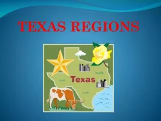
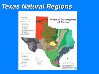
The regions of Texas are… Gulf Coastal Plain North Central Plains Great Plains Mountains and Basins
Location of Coastal Region • Covers 1/3 of the land of Texas • Northeast border is the Sabine River • Southeast border is the Gulf of Mexico • West border is the Balcones Escarpment
Coastal Climate……. • Hot and damp, humid • Tornadoes, hurricanes • 30-55 inches of rain per year
Coastal Cities…… • Austin (on the border) • Houston • Dallas (on the border) • Waco (on the border) • San Antonio • Texarkana • Corpus Christi • Brownsville
Way of life…. • The gulf coast is a major center of economic activity. The marshlands provide breeding grounds for ocean life, which make the fish and shrimp businesses very important. • The port of Houston is one of the 10 busiest ports in the world.
OIL AND GAS….. • Along the coastal region you will find many oil rigs that are on-shore and off-shore…. • The ocean gives easy access to ship the oil and gas to where it needs to go..
PLANTS • The land along the Gulf Coast is very near sea level. It is hard for water to drain off the land, since there is nowhere lower for the water to go. Much of the coast of Texas is made up of marshes----wetlands where a variety of tall grasses grow.
Coastal Animals…. • Many kinds of animals live in the coastal region… To name a few… • Quail • Hawks • Owls • Hundreds of other birds • Bald eagle • White tail deer • Foxes • Skunks • River otters • Bobcats • Alligators in the marshes!!! Some weigh up to 500 lbs!!!
The real road runner….. Can you name other coastal animals……
Landforms….. • Let’s look at our Texas map to see some landforms in the coastal region…..
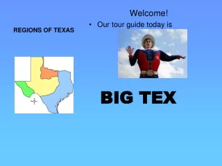
STOP……………. • Our next region we will look at is….. NORTH CENTRAL PLAINS A C D B
North Central Plains NORTH CENTRAL PLAINS
Location of North Central Plains • The North Central Plains is bordered in the north by the Red River. In the west, it includes a small piece of the Panhandle. • It is border on the east by the Caprock Escarpment in the panhandle and by the Balcones Fault to the southeast. Picture of Edwards Plateau
North Central Plains Climate • Central Texas is shaped by its many rivers and hills. The climate is subtropical. • In a single year the region can receive up to 48 inches of rain, and flooding is common near rivers and in low lying areas.
North Central Plain Cities….. • Fort Worth • Wichita Falls • San Angelo • Abilene
North Central Plain - Plants • Blue bonnets • Indian Paintbrush • Texas Oak Trees • Mesquite Trees
Indian Blanket Mesquite Tree Blue Sage
North Central Plain - Animals • Bobcat • White-tailed deer • Turkeys • Screech Owl • Mexican Freetail Bat • Cliff Swallow
NORTH CENTRAL PLAINS WAYS OF LIFE • RANCHING • COTTON AND WHEAT FARMING • NATURAL GAS FROM THE BARNETT SHALE
Landforms of North Central Plains • Let’s look at our Texas map to see some landforms in the Central Plains region.
STOP……………. • Our next region we will look at is….. the Great Plains A D C B
THE GREAT PLAINS GREAT PLAINS
Great Plains Cities • Amarillo • Lubbock • Abilene • Midland • Odessa
Location of Great Plains • Caprock Escarpment separates Great Plains from North Central Plains in the east. • In the north the border is the state of Oklahoma and in the west the border is the state of New Mexico. • The Southern border of the Great Plains is the Edwards Plateau • Geographic Features • In the North lie the High Plains which rises in elevation as you move west. • Llano Estacado which has thick grasses. • Deep canyons of the Palo Duro Canyon. • Edwards Plateau which is hilly and is a part of the Texas Hill Country.
Great Plains Climate • Dry air • Tornadoes • 20-30 inches of rain per year
Great Plains Way of Life • Farming - fruits, vegetables, watermelons, oats • Ranching - cattle, angora goats (mohair) • Cedar trees - fenceposts • Oil and gas
Great Plains Plants • Prickly pear • Yucca • Indian Paintbrush • Cactus
Animalsof the Great Plains • Pronghorn • Prairie Dog • Snakes • Horny Toad
Landforms of Great Plains • Take a look at the map!!!
Location of theMountains andBasins • Far west Texas • East border near Pecos River • South border is the Rio Grande • North border is New Mexico
Cities of theMountainsand Basins • El Paso • Pecos • Presidio
Climate of theMountains and Basins • Driest part of state • 8 inches of rain per year, 20 in mountains • Hot days, cool nights
Mountains and BasinsWay of Life • Ranching - cattle, sheep, goat • Farming - cotton, fruits, vegetables, cantaloupes (irrigation in El Paso and Pecos River Valley) • Oil and gas - part of Permian Basin
Plants of theMountainsand Basins • IT IS FLAT!!!!! • Some sagebrush
Landforms of the Great Plains • Let’s look at 0ur map!!!
And now…. • Let me introduce our Regions Group Project!!!
*The following are requirements for your UTOPIA: • Illustration of Texas • Illustration of your given region in Texas. • Climate • Way of life • Economy • Plants and animals • Landforms • Catchy slogan • Native American groups near your UTOPIA and an explanation of your interaction with them. • *This is a MAJOR GRADE!!!