Download
1 / 17
170 likes | 255 Vues
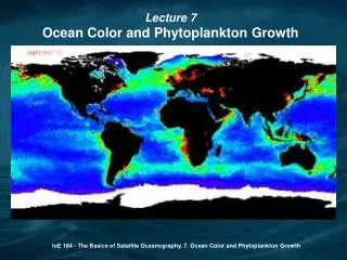
Brian Barnes, Chris Ellis, Bill Fisher, Chuanmin Hu, John Lehrter , Luke McEachron , Kathleen O’Keife , Blake Schaeffer, Bruce Spiering , Lauren Underwood 26 September 2012. Water Clarity Assessment along the Florida Keys Reef Tract Using Ocean Color Satellite DATA. Objectives.

E N D
Brian Barnes, Chris Ellis, Bill Fisher, Chuanmin Hu, John Lehrter, Luke McEachron, Kathleen O’Keife, Blake Schaeffer, Bruce Spiering, Lauren Underwood 26 September 2012 Water Clarity Assessment along the Florida Keys Reef Tract Using Ocean Color Satellite DATA
Objectives • Describe new satellite products • Applications of satellite data products in FKNMS Rezoning Effort • Ecological Research and Monitoring (W.33) • Florida Bay influences (W.24) • Researching Water Quality Issues (W.32) • Provide FKNMS with satellite data products • Discussion • Assess utility of data products as part of FKNMS Rezoning Effort
In situ water clarity measurements • April 2011, August 2012 • HyperPRO – hyperspectralKd • 26 stations, 53 profiles • 33 profiles passed QA • 10 concurrent with satellite
Validation of satellite water clarity Satellite derived Kd 488 (m-1) R2=0.91 HyperPRO in situ Kd 488 (m-1)
Status & Trends: average condition January April July October
Status & Trends: regional variation B C D E b BB c e F A d d β a γ (from Boyer, WQMP) α δ ε ζ UK MK Distance from Shore 0 – 4 km 4 – 8 km 8 – 12 km LK MQ DT
Status & Trends: seasonal variation Amplitude of Seasonal Cycle
Episodic events: Monthly mean -80.5 -81 -81.5 -82 2006 2002 2008 2010 2004
Episodic events: Monthly anomaly -80.5 -81 -81.5 -82 2006 2002 2008 2010 2004
Florida Bay Influences November 23, 2005
Florida Bay Influences December 7, 2003
Monitoring: track water masses December 20, 2003 (two weeks later)
Ecological Research and Monitoring Looe Key CREMP Station
Other remote sensing data sources • Temperature (MODIS, AVHRR) • Satellite overpasses several times daily • Chlorophyll, CDOM concentrations • Satellite algorithms in validation stage
Discussion • Use for zoning decision making • Temporal zoning • Based upon seasonal events • Zone specific regulations • Size, resource protection • Protect and preserve coral reefs • Minimize adverse socioeconomic impacts • Socioeconomic considerations • Provide water clarity for divers • Assess rezoning performance results based upon data products provided • Solicit feedback from WQPP, SAC