Download
1 / 1
10 likes | 143 Vues
Evaluation of Community Land Model Hydrologic Predictions Kaiyuan Y. Li 1 , Dennis P. Lettenmaier 1 , Ted J. Bohn 1 , and Christine Delire 2 Department of Civil and Environmental Engineering, Box 352700, University of Washington, Seattle, WA 98195, USA

E N D
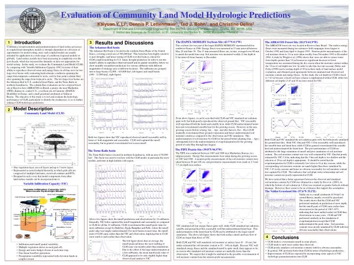
Evaluation of Community Land Model Hydrologic Predictions • Kaiyuan Y. Li1, Dennis P. Lettenmaier1, Ted J. Bohn1, and Christine Delire2 • Department of Civil and Environmental Engineering, Box 352700, University of Washington, Seattle, WA 98195, USA • 2. Institut des Sciences de l'Evolution, cc 61, Université Montpellier II - 34095 Montpellier FRANCE 1 Introduction 3 Results and Discussions The HAPEX-MOBILHY Soybean Site (43.7ºN 0.1ºW) The ABRACOS Forest Site (10.1ºS 61.9ºW) This soybean site was part of the larger HAPEX-MOBILHY experiment held in southwest France in 1986. Energy fluxes was measured in 15 min interval between May 28 and June 30. The 15 min measured fluxes are, in turn, averaged over 60 min to match the model time step. Soil moisture was measured weekly (1.6m depth at 0.1m interval) from January to December. • The ABRACOS forest site was located in Reserva Jaru, Brazil. The surface energy • fluxes were measured during two intensive field campaigns from August to • October 1992 and from April to August 1993. Neutron probe measurements of the • soil moisture down to 3.6 m were taken weekly from November 1991 to December • A study by Wright et al. (1996) shows that trees are able to extract water • from depths greater than 3.6 m because no significant decrease in forest • transpiration was measured during the dry season when the moisture content within • the 3.6 m of soil depth was low. In order to take this fact into account, Delire and • Foley (1999) used a rooting depth of 10 m in their study of land surface model • evaluation, and obtained good agreements between simulated and observed soil • moisture content and energy fluxes. In this study, the soil depth for CLM is fixed • to 3.43 m because a fixed soil layer scheme is implemented within CLM, while two • different soil depths (3.43 and 10 m) were tested for VIC. Confidence in representation and parameterization of land surface processes in coupled land-atmosphere models is strongly dependent on a diversity of opportunities for model testing, since such coupled models are usually intended for application in a wide range of conditions (regional models) or globally. Land surface models have been increasing in complexity over the past decade, which has increased the demands on data sets appropriate for model testing. In this study, we evaluate the Community Land Model (CLM) by comparing with Variable Infiltration Capacity (VIC) in terms of their ability to reproduce observed water and energy fluxes in off-line tests for two large river basins with contrasting hydroclimatic conditions spanning the range from temperate continental to arctic, and for four point (column flux) sites spanning the range from tropical to arctic. The two large river basins are the Arkansas-Red in U.S. southern Great Plains, and the Torne-Kalix in northern Scandinavia. The column flux evaluations are for a tropical forest site at Reserva Jaru (ABRACOS) in Brazil, a prairie site near Manhattan (FIFE), Kansas in central U.S., a soybean site at Caumont (HAPEX-Monbilhy) in France, and a small grassland catchment at Valdai in Russia. The objective of this study is to test and evaluate the hydrologic performance of CLM, particularly to identify the weaknesses, so as to further enhance CLM hydrologic predictions. The Arkansas-Red basin The Arkansas-Red basin is located in the southern Great Plains of the United States, covering a total area of 566,000 km2. This basin has been highly sensitive to past droughts, and hence testing of CLM over this basin is critical for CLM-coupled modeling for U.S. future drought prediction. In order to test the model’s ability to reproduce observed runoff and its spatial variability, below we show monthly streamflow predictions for various subbasins with different magnitudes of drainage area at different locations. The subbasins are grouped into to large basins (72,000 – 410,000 km2, left figure) and small basins (440 – 11,000 km2, right figure). Model Description 2 Community Land Model (CLM) From above figures, it can be seen that both CLM and VIC simulated net radiation quite well, but both poorly reproduced the observed ground flux. VIC reasonably well reproduced both the latent and sensible heat, while CLM underestimated latent heat and overestimated sensible heat for the growing season. However, in the non-growing season (before sowing, Jan. – Apr., and after harvest, Oct – Dec) CLM markedly overestimated bare ground evaporation and hence underestimated soil moisture content as compared to the observation and VIC simulation. This underestimation of soil moisture by CLM for the period before planting (Jan. – Apr.) subsequently led to the underestimation of evapotranspiration for the growing period of early May through late August. Both two figures show that VIC reproduced observed runoff reasonably well in terms of both magnitude and seasonality. CLM well captured the runoff seasonality, but in general overestimated wet season runoff. Both CLM and VIC simulated the net radiation quite well, but both poorly simulated the ground heat flux. Both VIC-10m and VIC-3.43m reasonably well reproduced the sensible heat and latent heat, while CLM in general overestimated the sensible heat and underestimated the latent heat. The poor performance of CLM are attributed to the large estimation of runoff and poor simulation of soil moisture content. The soil moisture content was very well estimated by VIC-10m but poorly estimated by VIC-3.43m, indicating that the 3.6m soil depth is too shallow and the selection of 10 m soil depth is appropriate. It should be noted that the evapotranspiration by CLM is extremely low (close to 0) in dry seasons, while the corresponding soil moisture contents are much higher than those simulated by VIC-3.43 in dry seasons and hence no obvious seasonality for soil moisture content was captured by CLM. This indicates that soil-plant-water relationship and soil moisture content are poorly represented in CLM. The FIFE Prairie Site (39.0ºN 96.5ºW) The Torne-Kalix basin Modeling Framework The FIFE was conducted between 1987 and 1989 near Manhattan, Kansas, in a tallgrass prairie. Energy flux measurements were taken during the growing season of 1987 and 1989. A neutron probe measurements of the soil moisture content were taken between 20 and 140 cm, and gravimetric measurements were made at 2.5 and 7.5 cm depth near surface. The Torne-Kalix basin is located in northern Scandinavia, with an area of 58,000 km2. This basin was used to test how well the CLM model, in particular the snow module, performs in high latitude code region. • One vegetation layer, ten soil layers and up to 5 snow layers; • Represented as nested subgrid hierarchy in which grid cells are • composed of multiple land units, snow/soil columns and PFTs; • Designed in such a way that model components from other • land surface models can be incorporated into it. We have noticed that a better agreement between the observed and simulated soil moisture contents by CLM was obtained in a study by Dai et al. (2003), in which the bottom of soil column (at 3.43m) was assumed as granite bedrock without drainage. However, there seems to be no evidences that support this assumption. Variable Infiltration Capacity (VIC) The Valdai Grassland Site (57.6ºN 33.1ºE) Valdai site is a small catchment (0.36 km2) in central Russia, mainly covered by grassland. The results shows that the CLM and VIC performed similarly in prediction of snow depth, but the runoff peak of CLM came earlier than observation for the period of 1967-1973, indicating that snow melted earlier in CLM than observations in some years. CLM and VIC performed similarly in the simulation of evapotranspiration except that CLM underestimated the peak value. Soil moisture contents were poorly simulated by CLM with less obvious seasonality than observations. Above two figures show the runoff predictions and observations for 14 subbaisns. Generally, VIC better captured the runoff magnitude and seasonality as compared to CLM for all the 14 subbasins. CLM overestimated the runoff peak value for most subbasins except for Raktfors, Pajala Rumphus and Pallo, where the runoff peak value was largely underestimated. For most basins in most time, the runoff peak of CLM came earlier than did VIC and observation, implying that in CLM snow tends to melt earlier than observation. VIC simulated all four energy fluxes quite well, while CLM simulated net radiation, sensible and ground heat flux reasonably well but underestimated latent heat. This underestimation of the latent heat by CLM can be attributed to the larger runoff simulation. The above left figure shows that both surface runoff and base flow of CLM are larger than those of VIC. 4 Conclusions The left figure shows that on average, the runoff peak and hence the snow melting of CLM came one month earlier than simulations. Due to the offset of the large underestimation at a few subbasins, the mean runoff peak value of CLM appeared to be only slightly higher than observed and similar to VIC. • CLM tends to overestimate runoff in some places; • CLM tends to melt snow earlier than observed; • CLM poorly simulates soil moisture contents with less obvious seasonality; • In general, VIC performs better than CLM in terms of hydrologic predictions; • Improvements of CLM are expected by incorporating some aspects of VIC • hydrologic parameterizations into CLM. Both CLM and VIC well simulated soil moisture at surface layer (0 – 10 cm), but under-estimated the soil moisture content at 10 – 140 cm depth. Because VIC well simulated energy fluxes and the simulated runoff is quite small, there appears to be no reason why simulated soil moisture content are markedly lower than the observation. We suspect that it might be attributed to the possible overestimation of soil moisture content from the neutron probe measurements. • Infiltration and runoff spatial variability; • Multiple vegetation classes in each grid cell; • Energy and water budget closure at each time step; • Non-linear baseflow generation; • Precipitation variability represented with elevation bands in • complex terrain