Download
1 / 19
220 likes | 596 Vues
GNSS: GPS was just the beginning. Tripp Corbin, CFM, GISP CEO eGIS Associates, Inc. Relationships Matter. What is GNSS?. Global Navigation Satellite Systems Any collection of Satellites which can be used to determine location on Earth. Current Active GNSS. GPS – US GLONASS – Russian

E N D
GNSS: GPS was just the beginning Tripp Corbin, CFM, GISP CEO eGIS Associates, Inc. Relationships Matter
What is GNSS? • Global Navigation Satellite Systems • Any collection of Satellites which can be used to determine location on Earth
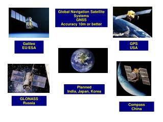
Current Active GNSS GPS – US GLONASS – Russian Galileo – European Union Compass - China
GNSS Basics • Location Determined based on Distance – Trilateration • Distance based on time • Typically need at least 4 Satellites for a position • Errors Caused by • Clock differences • Atmosphere • Multipath • Satellite Geometry
Global Positioning System - US • Navstar - Full operational constellation in 1994 • WGS 84 Datum • 31 Active Satellites • 3-4 Decommissioned Satellites • 6 Orbit altitude of 12,000 miles • 2 Frequencies at about 50 watts • L1 C/A & P – 1575.42 MHz • L2 P(Y) - 1227.60 MHz
GLONASS - Russian • Global Navigation Satellite System • Operational with 24 satellites in 1995 • System declined from 1996 to early 2000s • Rebirth 2000s to present (2011 at 24 again) • 19,000KM orbit • 24 active satellites, 3 on-orbit spares, 1 in maintenance, 1 in flight test phase • 3 launched in July 2013 destroyed in launch crash • Future funding in question
GLONASS – Frequency & more • Each Satellite has its own • Two Bands • L1 – 1602.56 MHz to 1615.5 MHz • L2 – 1240 MHz to 1260 MHz • Frequency Division Multiple Access • CDMA with L3 in 2011 (1202.25 MHz) • Signal Strength equal to GPS • PZ-1990 Datum – Earth Centered (16in ± from WGS 84)
Galileo – European Union • 4 Active Satellites • 2 satellites launched Oct 21, 2011 • 2 launched on Oct 12, 2012 • Full 30 Satellite Constellation by 2019 • Galileo Firsts • Galileo only post processed position – Jan 6, 2013 • Galileo only real time position – March 12, 2013 • 24 Operational Satellites by 2016
Galileo – Frequency & More • 4 Bands • E1 – 1575.42 MHz (Same as GPS L1) • E5a – 1176.45 MHz (Same as GPS L5) • E5b – 1207.14 MHz • E6 – 1278.75 MHz • Full 30 Satellite Constellation by 2019 • Galileo Firsts • Galileo only post processed position – Jan 6, 2013 • Galileo only real time position – March 12, 2013 • 24 Operational Satellites by 2016
Compass (aka Beidou-2) - China 2007 2012 China-sponsored military and civilian system 14 Satellites in operation Coverage area limited 35 Satellites when complete Same Freqs as Galileo Patent issues with Galileo
Regional GNSS Indian Regional Navigational Satellite System (IRNSS) - India Quasi-Zenith Satellite System (QZSS) – Japan
Indian Regional Navigation Satellite System (IRNSS) - India • First satellite launched in 2013 • Will consist of 7 Satellites by 2015 • 4 in Geosynchronous • 3 in Geostationary • Limited coverage • Frequencies • L5 – 1176.45 MHz • S – 2492.08 MHz
Quasi-Zenith Satellite System (QZSS) - Japan • Authorized in 2002 • 4 Satellites by 2018 • 7 Satellites total • First launched in Sept 2010 • Augment other systems
Future of GPS • New Satellites • More Frequencies • Civilian use • More signals & codes • Civilian • Military • Indoor GPS
New Civilian Frequencies • Allow improved atmospheric correction • Faster signal and position acquisition • Increased signal strength • L2C • Introduced in 2005 on Block IIR-M Satellites • Same Frequency as L2 P(Y) • Not encrypted • L5 – aka Safety of Life • Introduced in 2010 on Block IIF Satellites • In future can carry more data than others • Higher power transmission than L2C • Not encrypted
New Civilian Frequencies • L1C • Increases GPS compatibility with other GNSS • Higher power than L1 C/A • Still compatible with older GPS receivers • Deployed on Block III satellites (2014) • Full support of new Frequencies (24 Satellites) • L2C – 2016 (about 10 right now) • L5 – 2019 (about 4 right now) • L1C – 2020 (none right now)
New Block III GPS Satellites • Lockheed Martin • Up to 32 will be purchased • First launch in 2014 • Frequency Capability • L1 C/A & L1C • L2 P(Y) & L2C • L5 • New M code with Directional Antenna • Harder to Jam
New CNAV Messages • Transmitted on L2C & L5 • First test June 15-29, 2013 • 15 Message types such as: • 10 & 11 – Ephemeris • 12 – Reduce Almanac (7 Satellites at a time) • 13 – Clock differential correction • 14 – Ephemeris Correction • 30 – Clock & Ionosphere correction • Means improved performance, redundancy, and improved interference mitigation
Questions Tripp Corbin, CFM, GISP tcorbin@egisassociates.com 678-710-9710 Ext 21