Download
1 / 1
10 likes | 81 Vues
A Significant Hail Event over the Midlands of South Carolina on 9 April 2011. S. Hunter Coleman*, Michael Cammarata, Anthony Petrolito NOAA/National Weather Service WFO Columbia, SC *Email: hunter.coleman@noaa.gov. Large Hail Ingredients. Real-Time Diagnosis of Large Hail. Introduction.

E N D
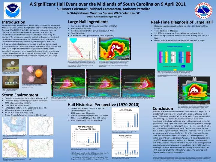
A Significant Hail Event over the Midlands of South Carolina on 9 April 2011 S. Hunter Coleman*, Michael Cammarata, Anthony Petrolito NOAA/National Weather Service WFO Columbia, SC *Email: hunter.coleman@noaa.gov Large Hail Ingredients Real-Time Diagnosis of Large Hail Introduction Multiple supercell thunderstorms moved across the Northern and Eastern Midlands of South Carolina during the late afternoon and evening hours on Saturday, 9 April 2011. A stalled frontal boundary extended from near Charlotte, NC southeastward towards the Florence, SC area. The thunderstorms tended to move southeastward and follow along this boundary. The atmosphere was quite unstable and supported continued thunderstorm development into the late evening hours. The National Weather Service received numerous reports of large hail from law enforcement, trained spotters, and the public. Multiple storms moved across Lancaster and Chesterfield counties producing golf ball size hail, with some of the larger hailstones measuring the size of baseballs near Lancaster. A few storms moved across Kershaw and Sumter counties also producing very large hail, up to baseball size near Dalzell, SC. There was considerable damage to vehicles, homes and property, including crops. • CAPE in the -10oC to -30oC layer (greater than 1000 J/kg) • Cold temperatures aloft • Residence time in the hail growth zone (BWER, WER) • Steep lapse rates • 0-6 km wind shear greater than 40 knots (supercells) • Statistical equations developed and put into a GUI (Graphical User Interface) • 4 year database of 241 cases • VIL, 500mb temperature, Freezing level are main predictors • Inputs – height of the 50 dbz core above the freezing level and -20oC level • Output is the percentage probability of hail 1.00 inch or larger -30oC CAPE > 1000 J/kg -20oC -10oC Low RH in the lower levels (less hail melting) Figure 8. 9 April 2011 21 UTC RUC analysis sounding at CAE. Positive CAPE is shown in the red shading and negative CAPE is shown in blue shading. Strong wind shear is present in the lower Troposphere. There is substantial CAPE in the hail growth zone (-10oC to -30oC). Figure 9. KCAE radar reflectivity cross-section at 0118 UTC 10 April 2011 using GR2Analyst software. Note the large area of high reflectivities well above the -20oC level. Also evident is a Weak Echo Region, which helps increase residence times of hail within thunderstorms. Weak Echo Region (WER) Strong Veering Profile Figure 1. Tennis ball to baseball size hailstones reported near Fort Mill, SC. Figure 14. Graphical User Interface (GUI) used by operational forecasters to assess in real-time the probability of one inch hail. The forecaster uses current or RUC analysis data as inputs by adjusting the slider bars to the desired values and a probability is returned. This GUI is based on a linear regression equation. Figure 2. Baseball size hailstones that were reported in Sumter County, SC. An orange was provided as a reference. Figure 3. Hailstones measuring 2 inches reported in Lancaster County, SC. -20oC -20oC -20oC Storm Environment -20oC 0213 UTC 0217 UTC 0221 UTC • Frontal boundary across the northern Midlands of SC • Shortwave energy traversing Appalachian Mountains • CAPE values exceeding 2000 J/kg • Lifted Index values -6oC to -9oC • Surface temperatures in the upper 70s to lower 80s • 500 mb temperatures around -13oC • 0-6 km Bulk Shear around 60 knots • Craven-Brooks SigSvr values exceeded 40,000 m3/s3 Hail Historical Perspective (1970-2010) 2141 UTC Figure 10. KCAE radar reflectivity volume using GR2Analyst software at 0213 UTC, 0217 UTC, and 0221 UTC 10 April 2011. This consecutive sequence of reflectivity volume data shows the large area of high reflectivity values (greater than 60 dBZ) remaining above the -20oC level in the hail growth zone. This extended period of time within the hail growth zone allowed hailstones to grow to significant sizes resulting in reports of hail the size of golf balls, tennis balls and baseballs. Figure 15. KCAE radar reflectivity cross-section at 2141 UTC 9 April 2011, corresponding to the time that the probability of hail GUI was being used from Figure 14. An overshooting top is evident, which signifies the strength of the updraft and helps recycle hailstones. Conclusion • Data record between 1970-2010 over the Columbia Forecast Area • 1659 reports over 23 counties • 268 hail reports (16%) larger than 1.50 inches • 26 hail reports (2%) larger than 1.75 inches • 1 hail report (<1%) 3.00 inches or larger Supercell thunderstorms developed on the afternoon of 9 April 2011 in a moderately unstable environment within a region of strong wind shear. Widespread large hail fell along the path of the storms with hail sizes reaching 3.00 inches. Several factors were in place which contributed to the large hailstones; long residence time within the hail growth zone, steep lapse rates, wind shear exceeding 40 knots and high values of CAPE within the hail growth zone. Hail sizes above 1.50 inches are quite rare in the Midlands of South Carolina, accounting for only 16% of all hail reports between 1970-2010. Hail sizes above 1.75 inches are extremely rare, accounting for only 2% of the reports during the same time. 69% of the reports on 9 April 2011 were larger than 1.50 inches, and 24% were larger than 1.75 inches. This event caused more than $600,000 worth of crop and property damage. Local research within the Columbia Forecast Office has resulted in the development of statistical equations that provide probabilities of large hail in real time. The height of the 50 dBZcore above the freezing level and above the -20oC level, along with the 500 mb temperature, VIL, Echo Top and freezing level are used as input values. Figure 11. Hail Size Frequency in the County Warning Area of WFO Columbia between 1970-2010. 21 UTC 21 UTC Figure 4. SPC Mesoanalysis 500 mb map showing heights (solid black lines), temperatures (red dashed lines) and winds (barbs). Figure 5. SPC Mesoanalysis 0-6 km shear vector map. Figure 12. Hail Size Frequency in the County Warning Area of WFO Columbia between 1970-2010 for the month of April. • 16% of reports were larger than 1.50 inches and less than 1% were larger than 1.75 inches for all April hail events Disclaimer: Reference to any specific commercial products, process, or service by trade name, trademark, manufacturer, or otherwise, does not constitute or imply its recommendation, or favoring by the United States Government or NOAA/National Weather Service. Use of information from this publication shall not be used for advertising or product endorsement purposes. 21 UTC • 9 April 2011 - 45 total reports with 69% of hail reports were larger than 1.50 inches and 24% were larger than 1.75 inches 21 UTC Figure 13. Hail Size Frequency in the County Warning Area of WFO Columbia on 9 April 2011. Figure 6. SPC Mesoanalysis MUCAPE map showing MUCAPE (red lines) and lifted parcel level (black dashed lines and shading). Figure 7. SPC Mesoanalysis 700-500 mb Lapse Rate map.