Download
1 / 1
10 likes | 146 Vues
Utilizing Surface Characteristics to Infer Hydraulic Conductivity in a Fault Zone (GSA 234-10) James Heffner (heff3813@uidaho.edu), Jerry Fairley, Leanne Tumlinson; Department of Geological Sciences, University of Idaho

E N D
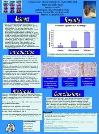
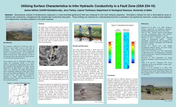
Utilizing Surface Characteristics to Infer Hydraulic Conductivity in a Fault Zone (GSA 234-10) James Heffner (heff3813@uidaho.edu), Jerry Fairley, Leanne Tumlinson; Department of Geological Sciences, University of Idaho Abstract: Geostatistical analysis of temperatures measured in a fault-controlled geothermal field was employed to infer fault hydraulic properties. Simulations indicate the fault is dominated by areas of relatively low conductivity, interspersed with isolated high conductivity flow paths. These findings are important for understanding fluid flow in petroleum and geothermal reservoirs, nuclear waste disposal, ore emplacement, and other problems in the earth sciences. Introduction The hydraulic conductivity of faults has been of interest to many people across a wide range of disciplines. Fault controls on fluid movement are important in ore genesis (Craw, 2001), underground storage of petroleum products, and the disposal of high-level nuclear waste. Fault hydraulics can also be an important factor in the effectiveness and economics of environmental remediation projects. Fault properties may be determined through rock sample core examinations (Evans, et al., 1997), analysis of geochemical emplacements (Craw, 2001), and examination and simulation of fracture systems (Berkowitz, et al., 2000; Viruete, et al., 2001). Several studies have illustrated the highly heterogeneous nature of hydraulic conductivity in fault zones, both in space and time (Sleep and Blanpied, 1992; Curewitz and Karson, 1997). This study takes an alternative approach, in which surface characteristics of geothermal waters along the fault zone are used to infer hydraulic properties. Figure 1. Location of the Study Area. Methods The study area is located near Borax Lake, found in the Pueblo Valley of southeast Oregon (Figure 1). The valley itself is one of the northernmost areas of the Basin and Range geological province, and thus consists of the typical horst and graben topography. The west side of the valley is bounded by the Pueblo Mountains in the south and Steens Mountain, a tilted fault block rising a mile above the valley floor. The east side of the valley is marked by the rise of the Trout Creek Mountains. Within the valley, the study focused on the Borax Hot Springs, just north of Borax Lake. The springs themselves are located along approximately 1 km of a left-stepping en echelon fault which parallels the main scarp at the base of Steens Mountain. At the time of the study, 176 individual spring vents were identified. Geostatistical analysis was applied to the spring data in order to generate the thermal field along the fault. Simulation was chosen in lieu of kriging as the temperatures in the study area were highly variable, and the output analysis was desired to be as representative as possible of the original data set (Deutsch and Journel, 1998; Goovaerts, 1997). Sequential Gaussian simulation was chosen due to the ease of computation and the lack of categorical variables in the data set. Photo: T. Williams Results and Discussion The results appear in Figure 2, which shows the thermal field generated from spring temperature data. The resulting map shows discrete areas of high temperature and broad areas of relatively lower temperature within and adjacent to the fault. The variance in temperature is due to differences in flow path length and the constriction of the pathways. This translates into media of higher and lower hydraulic conductivity. The thermal signature can then be used to determine the nature of fluid flow in a fault. However, one drawback to utilizing only spring data is the simulated temperatures located away from the fault are biased upward; the mean groundwater temperature is artificially high. To remedy this, the second simulation incorporated nearby ground temperatures as a proxy for near surface water characteristics. The results are similar to those in the first simulation, but more closely represent the nature of the study area. Photo: T. Williams Figure 2: Geostatistical Simulations Conclusion This study utilized a different approach to examine hydraulic conductivity in a fault zone. Geostatistical simulations generated a representative thermal field of the site. Both simulations show few discrete areas of high temperature and more abundant areas of relatively lower temperature. The thermal field can then be interpreted as few areas of high hydraulic conductivity accompanied by broader areas of lower hydraulic conductivity. This confirms results obtained through earlier studies regarding the nature of fluid flow through a fault, but allows for the investigation of hydrologic properties in a less invasive manner. References Berkowitz, B., O. Bour, et al., 2000. "Scaling of fracture connectivity in geological formations." Geophysical Research Letters 27(14): 2061-2064. Craw, D., 2001. "Tectonic controls on gold deposits and their environmental impact, New Zealand." Journal of Geochemical Exploration 73: 43-56. Curewitz, D. and J. A. Karson., 1997. "Structural settings of hydrothermal outflow: Fracture permeability maintained by fault propagation and interaction." Journal of Volcanology and Geothermal Research 79: 149-168. Deutsch, C.V., Journel, A.G., 1998. GSLIB: Geostatistical Software Library and User’s Guide. Oxford University Press, New York. Evans, J. P., C. B. Forster, et al., 1997. "Permeability of fault-related rocks, and implications for hydraulic structure of fault zones." Journal of Structural Geology 19(11): 1393-1404. Goovaerts, P., 1997. Geostatistics for Natural Resources Evaluation. Oxford University Press, New York. Sleep, N. H. and M. L. Blanpied, 1992. "Creep, compaction and the weak rheology of major faults." Nature 359: 687-692. Viruete, J. E., R. Carbonell, et al. 2001. "Two-Dimensional geostatistical modelling and prediction of the fracture system in the Abala Granitic Pluton, SW Iberian Massif, Spain." Journal of Structural Geology 23: 2011-2023. Acknowledgements The work described herein is supported by the Idaho EPSCoR Program, and by the National Science Foundation (NSF) under award number EPS-0132626. We also thank Nick Raterman, Kim Whipple, Eron Singleton, and Jennifer Hinds for assistance with data collection. Photo: J. Heffner Spring Temperatures With Ground Temperatures