Download
1 / 1
10 likes | 120 Vues
x. Σ. [n (A n /A mean + P n /P mean + HW n /HW mean )]. KYSIS index =. n. Development of the Kentucky Snowfall Index Scale (KYSIS) Ronnie Leeper, John M. Walker, and Gregory B. Goodrich Department of Geography & Geology, Western Kentucky University, Bowling Green, KY. Abstract

E N D
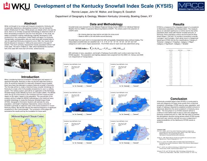
x Σ [n (An/Amean + Pn/Pmean + HWn/HWmean)] KYSIS index = n Development of the Kentucky Snowfall Index Scale (KYSIS) Ronnie Leeper, John M. Walker, and Gregory B. Goodrich Department of Geography & Geology, Western Kentucky University, Bowling Green, KY Abstract While not thought of as a state with frequent snowstorms, Kentucky will occasionally experience a devastating snowstorm that can disrupt the state’s infrastructure for days. While people can debate which one was the worst, there is no formally recognized methodology to determine which of these devastating snowstorms was the most disruptive. In this study, we adapt a snowstorm ranking methodology originally developed to rank snowstorms in the northeastern United States and apply it to Kentucky. Transportation and population data are used along with snowfall data to rank 24 significant Kentucky snowstorms since 1960. Our results show that the blizzard of January 6, 1996 as the worst storm in the past 47 winters. This storm primarily impacted the heavily populated northern half of the state. The storm of March 9, 1960, which blanketed the southern half of the state with more than 24 inches, ranked second. Introduction When considering historical snowstorm climatologies and impacts of significant blizzards, Kentucky is often not the first state that comes to mind. As would be expected of a state with infrequent heavy snowfall, there have been few attempts to analyze historical snowfall in Kentucky. The first step will be to create a historical heavy snowfall climatology for Kentucky to create a list of 24 possible snowstorms for use in a ranking system. The ranking system used will be an application of the Northeast Snowfall Impact Scale (NESIS) by Kocin and Uccellini (2004). The NESIS ranks the top 35 snow events in the northeast and then measures their impact on the region, based on the population. The second part of the analysis will be to adapt the NESIS methodology to the historical heavy snowfall climatology to create the Kentucky Snowfall Impact Scale (KYSIS). Geographic Information Systems will estimate the area, population, and length of highways impacted by various amounts of snowfall to generate an objective value of the worst snowstorm in recent Kentucky history. We will also discuss the historical frequency of significant snowstorms in the Commonwealth. The conclusion of this paper will summarize the results and lay the foundation for future work. Results KYSIS is a measure of the integrated impact of a snowstorm on Kentucky’s population and transportation. The measure places an elevated significance on winter storms that strike populated urban areas with heavier snowfall amounts. In Kentucky, these population centers would include the Blue Grass Region: I-64 and I-74 corridors connecting Louisville, Lexington, and Covington. Each winter storm is categorized based upon KYSIS into the five classifications; Category 5 “Extreme”, Category 4 “Crippling”, Category 3 “Major”, Category 2 ”Significant”, Category 1 “Notable”. Conclusion A Kentucky snowfall impact scale (KYSIS) is constructed to rank and categorize 24 heavy snow events from a historical snowstorm climatology. KYSIS uses the area, population, and length of highways impacted by weighted snowfall contours to objectively determine the worst snowstorm in Kentucky since 1960. The next phase in our KYSIS research will be to continue to look farther back in time to rank and categorize Kentucky snowstorms prior to 1960. We also plan to examine the atmospheric structure during winters where KYSIS events were both very common and did not occur to determine if seasonal prediction of the likelihood of KYSIS events is possible. • Data and Methodology • Snowfall totals were derived from the Midwest Regional Climate Center (MRCC) for individual National Weather Service (NWS) Cooperative Observing Stations (COOP). The criteria used in the selection of COOPs were: • No missing data two days before and after the snow event • Stations within a 20-mile buffer around Kentucky • Snowfall data from each storm is incorporated into GIS and spatially interpolated using ordinary kriging. The interpolated snowfall totals are classified into 1”-4”, 4”-8”, 8”-12”, 12”-16”, 16”-20”, 20”-24” and >24” categories to aid in storm impact assessment. The KYSIS value for each event was determined using: • GIS estimates of area, population, and length of highways found within each contour were input into the KYSIS equation. The population and highway datasets were acquired from the 2000 U.S. Census and 2005 U.S. Department of Transportation. December 22, 2004 Paducah, KY January 18, 1994 Louisville, KY Courtesy of National Weather Service Paducah, KY Courtesy of Anna Peak Literature Cited Cox, R., C. Swain, and T. Funk, 2004: Preliminary results of a heavy snow climatology across Kentucky and southern Indiana (1982-1996). National Weather Service. Last accessed May 30 2007 at http://www.crh.noaa.gov/lmk/soo/sclimo/index.php. Hartley, S., 1999: Winter Atlantic climate and snowfall in the south and central Appalachians. Physical Geography, 20, 1-13. Kocin, P. J., and L. W. Uccellini, 2004: A snowfall impact scale derived from Northeast storm snowfall distributions. Bulletin of the American Meteorological Society, 85, 177-194. Ross, T., and N. Lott., 2003: A climatology of 1980-2003 extreme weather and climate events. NOAA, Technical report 2003-01, 1-15. Schwartz, R. M., and T. W. Schmidlin, 2002: Climatology of blizzards in the conterminous United States, 1959-2000. Journal of Climate, 15, 1765-1772.