Download
1 / 1
10 likes | 146 Vues
Tools for working with the Geoscience Laser Altimeter System (GLAS) Data Products from the Ice, Cloud, and land Elevation Satellite (ICESat) Mission. John Maurer, Melinda Marquis & Matt Savoie National Snow and Ice Data Center, University of Colorado http://nsidc.org nsidc@nsidc.org

E N D
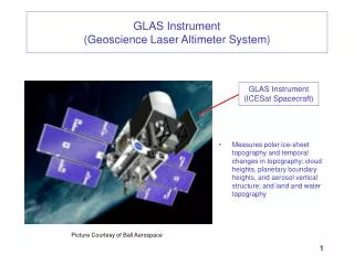
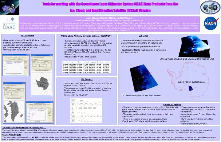
Tools for working with the Geoscience Laser Altimeter System (GLAS) Data Products from the Ice, Cloud, and land Elevation Satellite (ICESat) Mission John Maurer, Melinda Marquis & Matt Savoie National Snow and Ice Data Center, University of Colorado http://nsidc.orgnsidc@nsidc.org The Geoscience Laser Altimetry System (GLAS) is the sole instrument on the Ice, Cloud, and land Elevation Satellite (ICESat). The main objective of the ICESat mission is to provide accurate, high resolution data that will contribute to our understanding of ice-sheet mass balance investigations in the polar regions. The ICESat mission is an integral part of NASA’s Earth-Sun System Division. The GLAS science team and Science Computing Facility (SCF) have worked with NSIDC to provide a suite of tools for users to read, visualize and subset the ICESat/GLAS data. See: http://nsidc.org/data/icesat/tools.html for access to and documentation about these tools. • IDL Visualizer • Reads data from an ICESat/GLAS file and views graphical summaries of variables. • A quick-start tutorial is available on-line to help users get started viewing ICESat/GLAS data. • Developed by the GLAS SCF. • NSIDC GLAS Altimetry elevation extractor Tool (NGAT) • Extracts elevation and geoid data from GLAS altimetry products (GLA06 and GLA12-15) and outputs latitude, longitude, elevation, and geoid in ASCII columns. • The NGAT runs under IDL (6.0 or greater) or the free IDL Virtual Machine (IDLVM) available from Research Systems Inc. • Developed by NSIDC (Matt Savoie). • Subsetter • User enters bounding coordinates and temporal range of interest in a web form on NSIDC’s site • NSIDC provides the spatially subsetted data • Developed by NSIDC (Matt Savoie), in conjunction with the GLAS SCF. ENVI 3D model of subset: Byrd Glacier and the Ross Ice Shelf Record No. Date Time Lat. (deg.) Long. (deg.) Elevation (m) Geoid 372402615 03/07/2004 00:31:01.540 61.775047 213.540418 562.026 18.440000 372402615 03/07/2004 00:31:01.565 61.776580 213.539815 561.983 18.434615 372402615 03/07/2004 00:31:01.590 61.778114 213.539224 562.099 18.429231 372402615 03/07/2004 00:31:01.615 61.779650 213.538645 562.267 18.423846 372402615 03/07/2004 00:31:01.640 61.781187 213.538080 562.097 18.418462 372402615 03/07/2004 00:31:01.665 61.782726 213.537528 562.012 18.413077 • IDL Readers • Reads data from an ICESat/GLAS file and prints all the variables in ASCII format. • The readers run under IDL (6.0 or greater) or the free IDL Virtual Machine (IDLVM) available from Research Systems, Inc. • Developed by the GLAS SCF. Subset Region: available passes 2D view of composite GLA14 Elevation Data Fortran 90 Readers • This set of programs reads data from an ICESat/GLAS file and prints all the variables in ASCII format (identical output as IDL reader; see left). • These are sample codes to help users develop their own applications. • There is a separate program for each product type ("read_glaxx_file") where xx is the product number. • The programs are written in Fortan 90 and developed in a HP/UX 11.x runtime environment. • A relatively modern Fortran 90 compiler is required. • Runs on only HP/UX and some Sun platforms. • Developed by the GLAS SCF. Antarctic and Greenland Ice Sheet Altimetry Data The Level-2 ice sheet altimetry product (GLA12) contains the ice sheet elevation and elevation distribution calculated from algorithms fine-tuned for ice sheet returns. It also includes the laser footprint geolocation, reflectance, and the geodetic, instrument, and atmospheric corrections used to correct the range measurements. Parameters are at the full 40 shots per second resolution, but only for locations that fall within the ICESat ice sheet mask. Data granules contain approximately 23 hours (14 orbits) of data over the ice sheets. Sea Ice Altimetry Data The Level-2 sea ice altimetry product (GLA13) contains the sea ice freeboard and sea ice roughness calculated from algorithms fine-tuned for sea ice returns. It also includes the laser footprint geolocation, reflectance, and the geodetic, instrument, and atmospheric corrections used to correct the range measurements. Parameters will be at the full 40 shots per second resolution, but only for locations that fall within the ICESat sea ice mask. Data granules contain approximately 23 hours (14 orbits) of data over the sea ice regions.