Download
1 / 24
240 likes | 653 Vues
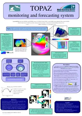
TOPAZ evaluation. L. Bertino, F. Counillon, P. Sakov Mohn-Sverdrup Center/NERSC. GODAE workshop, Toulouse, June 2009. TOPAZ System overview. System description Validation of TOPAZ Data Assimilation. Satellite Data SLA, SST, Ice, In Situ Data. Atmospheric Data. Sea-Ice model.

E N D
TOPAZ evaluation L. Bertino, F. Counillon, P. Sakov Mohn-Sverdrup Center/NERSC GODAE workshop, Toulouse, June 2009
TOPAZ System overview System description Validation of TOPAZ Data Assimilation
Satellite Data SLA, SST, Ice, In Situ Data Atmospheric Data Sea-Ice model Atlantic and Arctic model EnKF Data assimilation system Gulf of Mexico model Eco- system model Uncertainty estimates Ocean Primary production Hindcast studies User-targeted ocean forecasting Analyze the ocean circulation, sea-ice and biogeochemistry. Provide real-time forecasts to the general public and industrial users
The TOPAZ model system • TOPAZ3: Atlantic and Arctic • HYCOM + EVP sea-ice model • 11- 16 km horizontal resolution • 22 hybrid layers • EnKF • 100 members • Observations • Sea Level Anomalies (CLS) • Sea Surface Temperatures (NOAA) • Sea Ice Concentr. (AMSR, NSIDC) • Sea ice drift (CERSAT) • Argo T/S profiles (Coriolis) • Runs weekly, 10 days forecasts • ECMWF forcing • http://topaz.nersc.no/thredds • http://thredds.met.no (MERSEA…)
EnKF Correlations 3rd Jan 2006 8th Nov 2006
The HYCOM model • 3D numerical ocean model • Hybrid Coordinate Ocean model, HYCOM (U. Miami) • US Navy global forecasts • Hybrid coordinate • Isopycnal in the interior • Z-coordinate at the surface • Terrain following (sigma) • Nesting capability • Coupled • Sea-ice model • Ecosystem models • Large community (http://www.hycom.org)
Nesting • Bring dynamically consistent information from large-scale circulation to coastal seas • One-way nesting • “Flather” condition for barotropic mode • Avoids reflection of waves at the boundary • Simple relaxation for the baroclinic mode • And for the tracers • Arbitrary resolution and orientation of the nested grids
Effect of the upgradeWeekly SSS in Dec. 1999, free run MICOM BCM TOPAZ3 TOPAZ4
TOPAZ System overview System description Validation Data Assimilation
3 Validation criteriacf weather forecasting (Murphy, 93) • Consistency • Are the operational forecasts in agreement with known processes of the ocean circulation? • Accuracy • How close to reality are the results? • Performance (value) • Advantage over any trivial forecast? • climatology, persistence
Validation Metrics • Problems: • Validating and comparing GODAE systems consistently • Different model horizontal grids / Vertical coordinates • Large amounts of 4D data • Large data transfers • Solutions adopted (during Mersea Strand 1, 2003-2004) • 4 Classes of output products (3D, 2D, time series, residuals) • Common output grids (1/8th deg, projection...) • Self-documented file format (NetCDF) • Inter-operable file access (OPeNDAP/THREDDS)
Validation against hydrographic data June07 Sept07 Topaz2 Topaz3 IMR
Sparse profiles under iceNPEO deployment 2006 --- TOPAZ — NPEO *: North Pole Environment Observatory
Sea-ice edgeVisual comparison • Ice concentration from model in color, SSMI 15% ice contour in black. Ice drift is overlaid. • Good overall correspondence between model and data • Visual comparison allows identification of problematic regions • West of Novaya Zemlya - a tendency for the ice edge to drift too little to the north during a forecast cycle • South of Svalbard (Bear Island) model ice edge too far to the north • Issues related to model physics • Ice-ocean momentum exchange • Ice models neglect physics which may be important on small scales • Fast ice • MIZ
Forecast skills by region Barents Sea Alaska Bering Strait Central Arctic Greenland Sea Kara Sea
MERSEA sections updated • Blue: MERSEA Class2 sections • Red: Sections from IMR
TOPAZ System overview System description Validation Data Assimilation
Assimilation of Ocean Color in HYCOM-NORWECOM • Data: • Satellite Ocean Color (SeaWIFS) • Coupled Model: • HYCOM-NORWECOM • (7 compartments) • Problems: • Coupled 3-dimensional • physical-biological model. • High-dimension. • Non-Gaussian variables. • Perspectives: • Environment monitoring. • Fisheries. • Methodological developments • for future coastal HR systems.
Gaussian anamorphosis with the EnKF Anamorphosis: prior transformation of the variables in a Gaussian space (Bertino et al. 2003) Twin experiments (surface chlorophyll-a synthetic observations) Surface CHLa RMS error EnKF Cut-off of neg. values Gaussian Anamorphosis EnKF Simon & Bertino (OSD, 2009)