Download
1 / 29
290 likes | 483 Vues
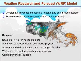
SPC Evaluation of the NAM-WRF Model: Spring Experiment 2006 NOAA Hazardous Weather Testbed. Steven Weiss and Jack Kain May 2006. Spring Experiment 2006. The 2006 Experiment consisted of a pre-implementation evaluation of the 12 km WRF-NMM Examined 12z run (Day 1) and 00z runs (Day 2 and Day3)

E N D
SPC Evaluation of the NAM-WRF Model:Spring Experiment 2006NOAA Hazardous Weather Testbed Steven Weiss and Jack Kain May 2006
Spring Experiment 2006 • The 2006 Experiment consisted of a pre-implementation evaluation of the 12 km WRF-NMM • Examined 12z run (Day 1) and 00z runs (Day 2 and Day3) • SPC focused on the performance of the NAM-WRF and NAM-Eta during 16 spring severe weather episodes • Mostly post-event assessments • Comparative performance between NAM-WRF and NAM-Eta from SPC forecaster perspective • Implications of using NAM-WRF as primary regional model input for SPC severe weather outlooks
Model Evaluation Methodologies • Looked at 8 key model fields for Outlook-scale severe weather forecasting plus soundings • 250 mb heights/isotachs (upper level jet) • 500 height/vorticity (mid level pattern/features) • 850 mb height/isotachs (low level jet) • EMSL (surface pattern/boundaries) • 2m dew point (moisture) • MUCAPE (instability) • 0-6 km vector shear (deep layer shear) • 3-hr accumulated precipitation • Although all fields examined, findings will focus on moisture, sounding structure, and precipitation
Model Evaluation Methodologies • SPC created special web pages for: • Display of four-panel graphics of NAM-WRF and NAM-Eta forecasts, difference fields, and “verifying” RUC or SPC sfcoa analyses • Time-matched from 00-84 hrs • Comparison of model soundings and observed soundings, including vertical difference fields • At radiosonde locations from 00-60 hrs • Input of evaluation findings, including subjective evaluation ratings of forecast skill • See www.spc.noaa.gov/exper/Spring_2006/
NAM-WRF Key Findings - Moisture • 2m dew point generally improved NAM-Eta sfcoa • 00hr initial moisture fields at 00z/16 Apr • Eta too moist in warm sector • WRF drier than Eta and closer to observed data at initial time NAM-WRF (WRF minus Eta)
NAM-WRF Key Findings - Moisture • 2m dew point generally improved NAM-Eta sfcoa • 84 hr forecast of return flow moisture valid 00z/5 Apr • WRF better with leading edge of 50s dew points staying south of Red River NAM-WRF (WRF minus Eta)
NAM-WRF Key Findings - Moisture • 2m dew point generally improved NAM-Eta sfcoa • 18 hr forecast of warm sector moisture valid 06z/8 Apr • WRF better with moisture in warm sector over the Southeast; Eta predicts values too high NAM-WRF (WRF minus Eta)
NAM-WRF Key Findings - Moisture • However, on rare occasion spurious drying in TX NAM-Eta sfcoa • 54 hr forecast of warm sector moisture valid 06z/8 Apr • WRF shows dry region in TX/OK • Drying appeared to impact CAPE and precipitation forecasts during 2 day period • Evident in forecast soundings for this episode NAM-WRF (WRF minus Eta)
60 hr WRF and Eta Soundings at FWD valid 12z 8 Apr • WRF (red/green) considerably drier in low levels compared to Eta (purple) • Also note “noisy” vertical structure in WRF low levels above PBL compared to much smoother Eta profiles • This characteristic was observed in WRF soundings on a number of occasions
24hr WRF and Observed Soundings at CRPvalid 00z 4 Apr • WRF (red/green) exhibits considerably shallower PBL depth compared to CRP raob (purple) • The shallow PBL structure in the WRF was noted many times with southeast low level winds at CRP • Is this related to PBL structure over adjacent Gulf of Mexico?
NAM-WRF Key Findings - Soundings • Forecast Soundings • SPC forecasters examine soundings frequently for temperature and moisture information in pre-convective environment • PBL structure most important (depth of moist layer, capping inversion, etc.) • Neither the WRF nor the Eta consistently handled PBL evolution reliably • This is a continuing challenge
NAM-WRF Evaluation - Precipitation • Precipitation Forecasts • 3-hr accumulated precipitation examined for timing and location for model convective development • Focus on mesoscale evolution of model precipitation and correspondence with observed radar or multi-sensor precipitation • Initiation • Direction and speed of system movement • Areal coverage • Configuration and orientation of mesoscale features • Perceived convective mode
Example 1 – 2 April 2006 • Strongly forced, very active severe day • Killer tornadoes in IL, MO and TN causing 26 deaths
NAM-WRF Evaluation - Precipitation • Sometimes WRF precipitation was better NAM-Eta Observed Pcpn • Day 1 Forecast of15 hr precipitation valid 03z/3Apr • Eta much delayed in developing severe storms IL into KY, TN and AR • WRF better than Eta (but also slow with initial severe storms) NAM-WRF (WRF minus Eta)
NAM-WRF Evaluation - Precipitation • Sometimes WRF precipitation was worse NAM-Eta Observed Pcpn • Day 3 Forecast of 75 hr precipitation valid 03z/3Apr • Eta too far west with severe storms IL into KY/TN and AR • This WRF run failed to develop storms in TN Valley until 6 hrs after this time NAM-WRF (WRF minus Eta)
Example 2 – 2 May 2006 • Weakly forced regional severe day • Tornadoes, hail larger than 4” and 85 mph winds
NAM-WRF Evaluation - Precipitation • Sometimes neither model was good NAM-Eta Observed Pcpn • Day 2 Forecast of54 hr precipitation valid 06z/3May • Neither model predicted night time TX severe storms well NAM-WRF (WRF minus Eta)
Example 3 – 29 April • Period of low synoptic scale predictability • SREF showed large spread • Local severe weather day • Tornadoes and wind damage southeast TX and southern LA
NAM-WRF Evaluation • SREF Spaghetti chart of 5460 m 500 mb height contour • Enhanced uncertainty in upper low evolution over Central States
NAM-WRF Evaluation • Large 500 mb differences between WRF and Eta NAM-Eta RUC Analysis • 72 hr Eta forecast valid 00z 30 Apr correctly predicted single upper low • WRF forecast shows double upper low structure in Central US • Evolution of boundaries, moisture, and instability reflected differing synoptic patterns NAM-WRF (WRF minus Eta)
NAM-WRF Evaluation - Precipitation • During late April case the Eta pattern was better NAM-Eta Observed Pcpn • Day 3 Forecast of 72 hr precipitation valid 00z/30 Apr • More accurate Eta synoptic scale forecast resulted in better prediction of storms NAM-WRF (WRF minus Eta)
Subjective Evaluation Scores • Subjective ratings of 0 to 10 were assigned for Day 1, Day 2, and Day 3 forecast periods for 16 active severe weather days • 0 rating – very poor correspondence with observed wx • Poor precipitation guidance to severe weather forecasters • 10 rating – excellent correspondence with observed wx • Excellent precipitation guidance to severe weather forecasters
Mean Subjective Precipitation Scores • WRF evaluation scores better on Day 1 • Eta evaluation scores higher on Day 2 and Day 3 • Caveat – small sample size
NAM-WRF Evaluation - Reflectivity • Reflectivity now available from 12 km NAM-WRF • Total reflectivity contributions from grid scale microphysics and parameterized convection • SPC experience with simulated reflectivity from 4.5 km experimental WRF-NMM has been very positive • Higher resolution and explicit precipitation processes only • More realistic reflectivity structures/magnitudes compared to 12 km WRF • Early experience with NAM-WRF reflectivity suggests 1-hr precipitation and instantaneous precipitation rate may provide similar information as reflectivity • When displaying output with higher resolution accum. pcpn scale
NAM-WRF Evaluation - Reflectivity 27 hr NAM-WRF Forecasts Valid 03z 25 May Simulated 1 km AGL Reflectivity Instantaneous Pcpn Rate
NAM-WRF Evaluation - Reflectivity 27 hr NAM-WRF Forecasts Valid 03z 25 May Simulated 1 km AGL Reflectivity 1-hr Accumulated Pcpn
NAM-WRF Evaluation - Precipitation 27 hr NAM-WRF Forecasts Valid 03z 25 May 3-hr Accumulated Pcpn 1-hr Accumulated Pcpn • Good news - WRF often provides more detailed pcpn structure compared to Eta • Tracks of heavier pcpn cores evident in WRF output (rarely seen in Eta)
SPC NAM-WRF Evaluation • Conclusions • Low level moisture • Better in WRF (thumbs up) • Pre-convective PBL sounding structure • WRF often different but not necessarily better (thumbs sideways) • Precipitation • WRF often exhibits more detailed structures (thumbs up) • At times WRF evolution is difficult to understand (thumbs sideways) • For severe weather forecasting, WRF sometimes better; Eta sometimes better (cautious thumbs sideways) • Synoptic patterns • Generally similar, although some evidence that WRF predicts deeper 500 mb troughs compared to Eta (thumbs sideways) • SPC Recommendation – a cautious thumbs up
Acknowledgements • Greg Carbin (SPC) • Jason Levit (SPC) • David Bright (SPC) • Gregg Grosshans (SPC) • John Hart (SPC) • SPC Forecasters