Download
1 / 8
80 likes | 90 Vues
A magnitude 7.1 earthquake occurred in Catigbian, Philippines, resulting in at least 30 deaths and various damages. Learn more about seismic activity and earthquake safety measures.

E N D
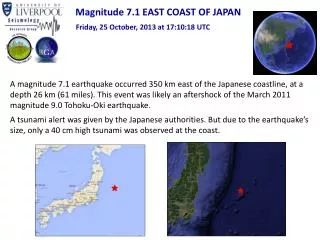
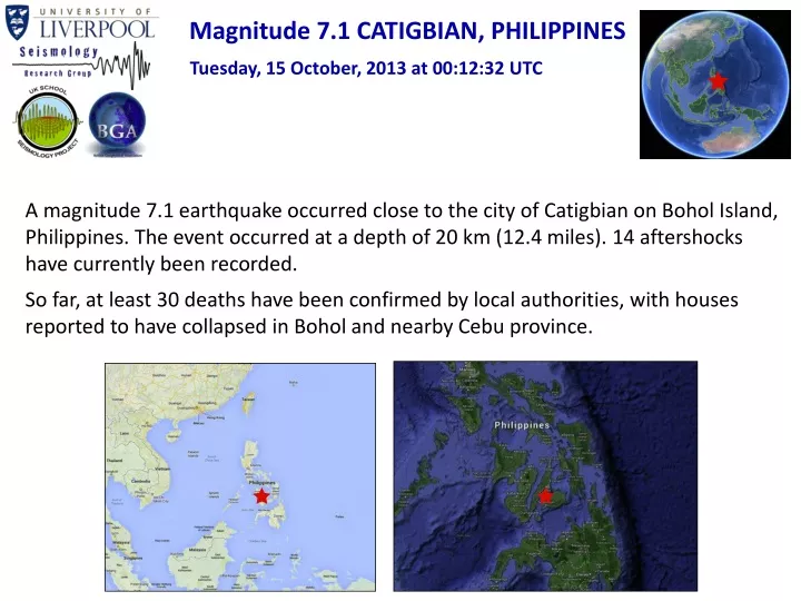
Magnitude 7.1 CATIGBIAN, PHILIPPINES Tuesday, 15 October, 2013 at 00:12:32 UTC A magnitude 7.1 earthquake occurred close to the city of Catigbian on Bohol Island, Philippines. The event occurred at a depth of 20 km (12.4 miles). 14 aftershocks have currently been recorded. So far, at least 30 deaths have been confirmed by local authorities, with houses reported to have collapsed in Bohol and nearby Cebu province.
Magnitude 7.1 CATIGBIAN, PHILIPPINES Tuesday, 15 October, 2013 at 00:12:32 UTC Destructive shaking (VIII) was felt on Bohol Island, within 50km of the epicentre. Very strong shaking (VII) was felt at distances of 50-100 km from the epicentre. Shaking intensity
Magnitude 7.1 CATIGBIAN, PHILIPPINES Tuesday, 15 October, 2013 at 00:12:32 UTC USGS PAGER Population Exposed to Earthquake Shaking Overall, the population in this region resides in structures that are a mix of vulnerable and earthquake resistant construction. The predominant vulnerable building types are reinforced concrete and heavy wood frame construction. Yellow alert level for shaking-related fatalities. Some casualties and damage are possible and the impact should be relatively localized. Past yellow alerts have required a local or regional level response. Yellow alert level for economic losses. Estimated economic losses are less than 1% of GDP of the Philippines. Images courtesy of the US Geological Survey
Magnitude 7.1 CATIGBIAN, PHILIPPINES Tuesday, 15 October, 2013 at 00:12:32 UTC Earthquake and historic seismicity The earthquake epicentre (red star) is plotted on the map with regional seismicity since 1973. The islands are familiar with large and damaging earthquakes due to its location at the intersection of three major tectonic plates. The region within 500 km of the October 15 earthquake has hosted 19 events of M6 or greater. One of these, a M 6.8 earthquake 70 km to the east of the October 15, 2013 event in 1990, caused several casualties. Image courtesy of the US Geological Survey For full list of earthquakes numbered in the figure, please visit http://earthquake.usgs.gov/earthquakes/eventpage/usb000kdb4#pager_historic
Philippine Sea plate Sunda plate 10 cm/yr Magnitude 7.1 CATIGBIAN, PHILIPPINES Tuesday, 15 October, 2013 at 00:12:32 UTC Tectonic summary The earthquake occurred due to shallow thrust faulting within the crust of the Sunda plate. At the latitude of this earthquake, the Philippine Sea plate moves towards the west-northwest with respect to the Sunda plate at a rate of approximately of 10 cm/yr and subducts beneath the Philippine Islands. The figure on the left shows the style of faulting (focal mechanism), and the right one shows schematically how plates associated with the thrust faulting move.
Magnitude 7.1 CATIGBIAN, PHILIPPINES Tuesday, 15 October, 2013 at 00:12:32 UTC Aftershock seismicity So far, 14 aftershocks have been recorded by the USGS. The largest of these was a magnitude 5.9 earthquake at 09:52 UTC. Most aftershocks appear to have occurred directly to the north and to the west of the mainshock epicentre (red star).
Magnitude 7.1 CATIGBIAN, PHILIPPINES Tuesday, 15 October, 2013 at 00:12:32 UTC Seismogram recordings by various seismometers across the UK First body wave arrivals Surface waves Time of earthquake
Magnitude 7.1 CATIGBIAN, PHILIPPINES Tuesday, 15 October, 2013 at 00:12:32 UTC Find out more…. • BGS (British Geological Survey) – seismology and earthquakes – frequently asked questions http://www.earthquakes.bgs.ac.uk/education/faqs/faq_index.html • IRIS (Incorporated Research Institutions for Seismology) – learning about earthquakes http://www.iris.edu/hq/programs/education_and_outreach/students • UK School Seismology Project – classroom activities, videos and support documents http://www.bgs.ac.uk/schoolseismology/home.html • USGS (United States Geological Survey) – FAQs, glossary, posters, animations http://earthquake.usgs.gov/learn/ • USGS summary of the Philippines earthquakehttp://earthquake.usgs.gov/earthquakes/eventpage/usb000kdb4#summary • BBC News report and video from 15th October 2013 • http://www.bbc.co.uk/news/world-asia-24530042