Download
1 / 35
370 likes | 496 Vues
Gliding and the Weather. Nothing makes as much difference as picking the right days to fly on. So: What is “good gliding weather”? How can we forecast it?. Air masses and Fronts Air in different places has different temperture, humidity etc. Call a large area of similar air an air mass

E N D
Nothing makes as much difference as picking the right days to fly on. So: • What is “good gliding weather”? • How can we forecast it?
Air masses and Fronts • Air in different places has different temperture, humidity etc. • Call a large area of similar air an air mass • Fronts occur where air masess meet • A cold front occurs where cold air is undercutting warmer air • A warm front is where warm air is overriding cold air • Both lead to cloud and precipitation • We get lots of them!
Mid-latitude Depressions • Usually associated with fronts and precipitation • Often also high winds near centre • Move from west to east • This is why we get lots of fronts!
Gliding Weather • For a day to be any good we need to be able to stay up • Can get lift from: • Hills • Thermals • Wave • What sort of weather do we need for each one?
Hill Lift • Wind must be blowing towards ridge—within about 45° • Must be strong enough—about 10kts minimum • Not too strong—depends on direction but about 25kts max • Not raining!
Thermals • Sun heats ground • Ground heats air • Air rises in bubbles • Gliders and soaring birds circle in rising air • Thermals may be topped by cumulus clouds or “blue”
What do we need? • Sunshine (spring or summer) • Air must be unstable enough to allow convection but not too unstable or it gets showery • Not too windy • Not easterly (at Portmoak)
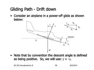
How does it work? • Wind blows over mountains • Standing waves set up downwind • Glider sits in rising part of wave and goes up
What do we need? • Right wind direction—roughly NW • Stable layer • Moderate wind strength, typically 15–20kts at surface • Increasing wind strength with height • Roughly constant wind direction at height • Straight isobars or slight anticyclonic curve • Luck!
What can go wrong? • Depressions and Fronts • Showers and Storms • Sea Breezes • Fog • Flooding • Easterlies
Depressions and Fronts • Forecasting depressions is not too hard • But forecasting the timing of fronts is (e.g. last Sunday) • Look for gaps, even short ones • Keep checking—long range forecasts are often wrong
Showers and Storms • Can occur when there is deep instability (e.g. last Sunday) • Common in northerly airstreams in winter • Winter showers generally worst near coast so more of a problem in north-easterly winds than north-westerlies • Summer showers and thunderstorms generally require some heating by the sun to get them started so most likely in afternoon
Sea Breezes • Happen when heating inland produces inflow of air • Thermals on the front often enhanced • Sea air behind front is cold and damp, therefore dead • Can cause a change of wind direction • Can be held back by westerly wind • Only solution to get away before it arrives
Easterlies • No reliable ridges • Poor or no thermals due to sea air • Cold and damp in winter • Can bring fog
Stability • Rising air exapands and therefore cools (PV = nRT etc.) • This is the Dry Adiabatic Lapse Rate (DALR) • Approximately 3°C per 1000ft • Saturated air (i.e. clouds) release latent heat • Therefore cool more slowly • At the Saturated Adiabatic Lapse Rate SALR
Stability • Actual decrease of temperature with height is the Environmental Lapse Rate (ELR) • Lapse rate > DALR => unstable • Lapse rate < SALR => stable • SALR > Lapse rate > DALR => conditionally unstable
Weather Forecasts • Check 24, 48, 72 hour forecast synoptics for position of depressions, fronts, wind strength & direction • Keep checking back—they can change a lot • Compare with, say, met office 3-day forecast • If there’s a chance of thermals or wave check the forecast sounding
Weather Observations • Met office • Visible and IR satpics (hourly) • Rainfall RADAR • Observations for Edinburgh & Leuchars • Portmoak • Webcam • Observations • The Window