Download
1 / 30
310 likes | 621 Vues
Weather Data from Commercial Aircraft (aka AMDAR, MDCRS, ACARS. TAMDAR). October 24, 2008 David Helms david.helms@noaa.gov NOAA/NWS Office of Science and Technology. Why NOAA Observes the Atmosphere? Current verses Objective Resolution Requirements. ▼. Current. ▼. Objective Req. ▼. ▼.

E N D
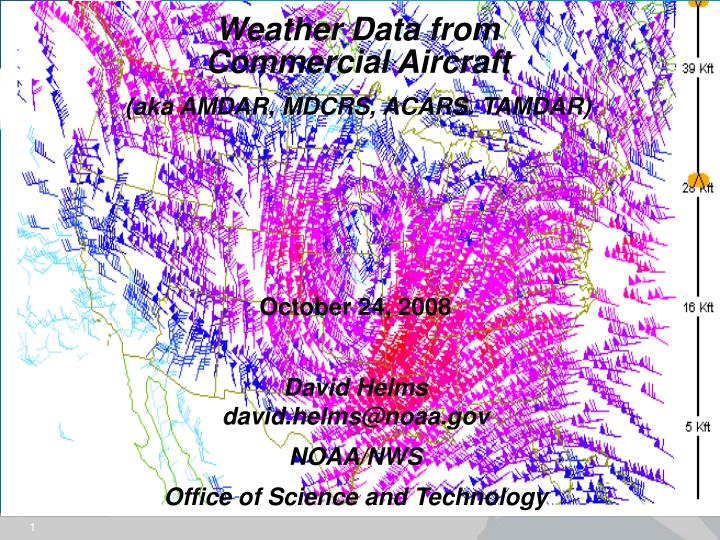
Weather Data from Commercial Aircraft • (aka AMDAR, MDCRS, ACARS. TAMDAR) October 24, 2008 David Helmsdavid.helms@noaa.gov NOAA/NWS Office of Science and Technology
Why NOAA Observes the Atmosphere?Current verses Objective Resolution Requirements ▼ Current ▼ Objective Req. ▼ ▼ Reference: Schlatter, et al, 2005: A Phenomenological Approach to the Specification of Observational Requirements
Integrated Upper-Air Observing System (IUOS) • IUOS characteristics – Future IUOS will be: • Adaptable, extensible, stable, continuous, and quality assured • Cost-effective – avoid unnecessary duplication • Serving multi-purposes - including driving Earth-system models • Final Operating Capability: • “Optimal” mix of NOAA and non-NOAA observation platforms including bothin situ and remote sensors
What is AMDAR? • Aircraft Meteorological DAat and Reporting (AMDAR): • An international effort within the World Meteorological Organization (WMO) to coordinate the collection o f environmental observations from commercial aircraft • U.S. AMDAR - Meteorological Data Collection and Reporting System (MDCRS): • A private/public partnership established in early 1980’s to facilitate the collection of atmospheric measurements from commercial aircraft to improve aviation safety • Communications: ARINC and SITA air-to-ground network • Sensors: TAT Probe for temperature and PTOT Tube for wind; WVSS is GFE • On-board Data Processing: Aircraft avionics software (Honeywell, etc) • AirDat, LLC - Tropospheric Airborne Meteorological Data Reporting (TAMDAR) • A private company established in 2002 from a NASA Langley CRIDA for GA Safety. AirDat is a for profit company that sells weather data to the Wx Enterprise and air-to-ground communications and services to the air carriers • Communications: Satellite through Iridium • Sensors: Turn-key suite – temperature, RH, winds, EDR, LED icing • On-Board Data Processing: Embedded in TAMDAR probe
CONUS: 150,000 Observations per Day U.S. AMDAR (MDCRS) • Participants: • American, Delta, FedEx, Northwest, Southwest, United, United Parcel Service • NOAA and FAA • 1,500 participating aircraft, mostly Boeing and Airbus
24hrs AMDAR Data Collection:Southwest U.S. 32 1 0 6 7 6 7 5
TAMDAR • Participants: • Mesaba, PenAir, Horizon, Republic, Chautauqua, Shuttle America • AirDat, LLC • 250 Aircraft – Saab 340, ERJ, CRJ 30,000 Observations per Day
Balloon Climb Rate: ~1.0kft/min AMDAR Data Collection:Comparison to Radiosonde Avg Wind: 60 Kts +50min 50 Kft Ascent Descent +40min 40 +30min 30 -28min +22min +20min 20 +10min -20min +10min 10 +5min -10min Aircraft Climb Rate: ~1.5kft/min Aircraft Descent Rate: ~1.0kft/min 125 100 75 50 25 50 75 100 125 25 Distance (NM) Distance (NM) Aircraft Speed 600 mph 600 mph 290 mph
NWS Forecast Office Applications • Data Comparison (Radiosonde, Radar, Profilers) • Marine (Wind and Wave Forecasts) • Fire Weather (Haines Index, Mixing Heights) • High Wind Events (Santa Ana, Front Range, Synoptic) • Aviation (Ceiling, Visibility, LLWS) • Winter(Precipitation Type, Lake Effect Snow) • Convective Storms(Watch and Warning Decisions)
Data Comparison Wind Estimates from Doppler Radar Wind Profilers Commercial aircraft GOES and POES Satellites Radiosondes Numerical models
High Winds Schematic of Santa Ana winds in southern California
High Winds Santa Ana AREA FORECAST DISCUSSIONNWS SAN DIEGO CA1120 PM PST FRI DEC 22 2006 .DISCUSSION... UPDATE TO UPGRADE THE WIND ADVISORY FOR THE INLAND EMPIRE AND THE SANTA ANA MOUNTAINS AND FOOTHILLS TO A HIGH WIND WARNING THROUGH EARLY AFTERNOON SATURDAY. RECENT ACARS SOUNDINGS FROM ONTARIO SHOW A VERY IMPRESSIVE SUBSIDENCE INVERSION NEAR 700 MB FAVORABLE FOR MOUNTAIN WAVE DEVELOPMENT AS WELL AS AN OVERALL STRONG WIND FIELD BELOW 700 MB WITH WINDS UP TO 50 KNOTS OR SO. WINDS IN THE WINDIER LOCATIONS...BELOW THE CAJON PASS AND NEAR FREMONT CANYON HAVE GUSTED TO AROUND 60 MPH IN THE PAST HOUR.
High Winds Santa Ana AMDAR sounding at 0411 UTC December 23, 2006 from Ontario, California showing mountain top inversion and strong wind field.
Winter Precip @ SDF KSDF 151843Z 06015KT 2 1/2SM RA BR OVC013 01/M01 A3001 RMK AO2 RAB30 RAIN
Winter Precip @ SDF METAR KSDF 160156Z 05009G17KT 5SM -PL BR OVC020 M01/M04 A3009 RMK AO2 FZDZE55PLB55 SLP192 P0001 T10111039 = FZRA, FZDZ, PL
Winter Precip @ SDF KSDF 160556Z 04009KT 4SM -PL BR OVC018 M03/M04 A3006= KSDF 160456Z 04010KT 6SM -PL BR OVC020 M02/M04 A3007= ICE PELLETS
AMDAR Future: Building on our Success Adding Water Vapor to Data Collection: • AMDAR/Water Vapor Sensor System • (WVSS II) • 2005: 25 sensors installed on UPS B-757 • 2008-2009: Re-engineered WVSSII to be installed on 31 SWA and 25 UPS • TAMDAR: • Since 2004: 250 sensors installed on various aircraft • AirDat is completing its adding the TAMDAR sensor to 450 aircraft in 2009
AMDAR Links: AMDAR Flyer http://www.wmo.ch/web/aom/amprog/Publications/Final%20Production%20AMDAR%20Flyer.pdf U.S. AMDAR Page http://amdar.noaa.gov/ Automated Meteorological Reports from Commercial Aircraft by Bill Moninger, Rich Mamrosh, and Pat Pauley (2003). Published in the February, 2003 issue of the Bull. Amer. Meteor. Soc. 84, 203-216.http://amdar.noaa.gov/docs/bams/ Optimization Requirements Document for the Meteorological Data Collection and Reporting System / Aircraft Meteorological Data Relay System, 2006, submitted to NOAA by ARINC. http://amdar.noaa.gov/docs/ARINC_Optimization_%20Req_March2006.pdf
Comments??? David Helms301-713-3557 x193 david.helms@noaa.gov NOAA/NWS Office of Science and Technology
Observation Accuracies – Temperature and Wind Speed - More discussions of observed data quality will follow Comparison of AMDAR and GPS radiosonde winds
Temperature Observation Counts North American Domain (20-70 North, 60-140 West) January 2006 2500 Aircraft Obs vs. 200 Radiosonde Obs per Layer Count by Pressure Layer (mb) Avg # Reports per 6hr Cycle (+/- 3 hr window) per Layer
Wind Observation Counts North American Domain (20-70 North, 60-140 West) January 2006 2500 Aircraft Obs vs. 200 Radiosonde Obs per Layer Count by Pressure Layer (mb) Max Count = VAD Winds Avg # Reports per 6hr Cycle (+/- 3 hr window) per Layer
Relative Humidity Observation Counts North American Domain (20-70 North, 60-140 West) January 2006 300 Aircraft Obs vs. 170 Radiosonde Obs per Layer Count by Pressure Layer (mb) Avg # Reports per 6hr Cycle (+/- 3 hr window) per Layer
AMDAR Data Collection: Sometimes too much data?? Average Daily MDCRS Aircraft Soundings(Ascents and Descents) 43 5 7 1 24 1 3 151 5 3 54 SFO: 78OAK: 39SMF: 10MHR: 7SJC: 7FAT: 1142 5 13 9 2 5 1 10 18 131 135 JFK: 64EWR: 39LGA: 32135 13 157 26 15 5 15 13 17 13 20 142 1 53 5 100 17 31 13 9 4 6 8 18 64 2 LAX:120SAN: 24ONT: 23BUR: 3170 9 9 7 2 5 170 208 1 7 3 10 88 22 DAL: 31DFW: 23AFW: 1064 1 2 64 4 1 3 2 8 14 2 7 35 1 6 7 9 7 2 22 96 Numbers indicate average number of ascent/descent soundings per day during the week of April 10, 2005
AMDAR Data Collection:Spatial Coverage Most Observations Above 25K ft Most Ascents/Descents In the Midwest and East and West Coasts MDCRS Data: Surface to 15K ft MDCRS Data: 15Kft to 40K ft
AMDAR Data Collection:Temporal Coverage Weekly Data Availability Varies by 40% Daily Data Availability Varies by 60%