Download
1 / 18
210 likes | 255 Vues
ArcGIS Data Reviewer: Assessing Positional Accuracy. Roslyn Dunn. What is ArcGIS Data Reviewer?. Data Quality Management for ArcGIS. Provides Rule-based validation Interactive tools Track errors For individuals and enterprise Saves time/money Less rework For multiple domains

E N D
ArcGIS Data Reviewer:Assessing Positional Accuracy Roslyn Dunn
What is ArcGIS Data Reviewer? Data Quality Management for ArcGIS Provides Rule-based validation Interactive tools Track errors For individuals and enterprise Saves time/money Less rework For multiple domains Configurable Extendable Validate EnterpriseWorkflow Summarize Review ArcGIS Data Reviewer: Assessing Positional Accuracy
What is ArcGIS Data Reviewer? Data quality management in the ArcGIS platform Data Reviewer for Desktop ArcMap ArcGIS Pro Data Reviewer for Server Standard or higher Data Reviewer API JavaScript FLEX Web AppBuilder for ArcGIS Desktop Web Device Web GIS ArcGIS Online Portal Server Online Content and Services ArcGIS Data Reviewer: Assessing Positional Accuracy
ArcGIS Data Reviewer: Assessing Positional Accuracy Spatial (position, geometry, topology) Attributional (correctness of attributes) Spectral (band depth) Temporal (appropriate date) Radiometric (capture piece of electromagnetic spectrum) Forms of Geospatial Data Accuracy ArcGIS Data Reviewer: Assessing Positional Accuracy
ArcGIS Data Reviewer: Assessing Positional Accuracy Data needs to be in the “right” place for intended purpose Usually scale-dependent to some degree All else being equal, less accurate is less valuable Data products usually need to conform to a specification ASPRS Positional Accuracy Standards November 2014 Orthoimagery Digital Planimetric Data Digital Elevation Data DMA - Error Theory as Applied to Mapping, Charting, and Geodesy Concepts ArcGIS Data Reviewer: Assessing Positional Accuracy
ArcGIS Data Reviewer: Assessing Positional Accuracy Accuracy The closeness of the best estimated value obtained by the measurements to the “true” value of the quantity measured How well does the measured quantity compare to the “true” value? Positional Accuracy The Quantifiable value that represents the positional difference between two geospatial layers or between a geospatial layer and reality Circular Error (CE) is an error measurement for both X & Y Linear Error (LE) is generally an error measurement for Z (elevation) RMSE is a statistical measurement of the variance between the residual values Definition of Terms ArcGIS Data Reviewer: Assessing Positional Accuracy
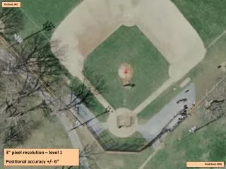
ArcGIS Data Reviewer: Assessing Positional Accuracy Circular Error – a two-dimensional error measure (X, Y) CE 90, 95, 99 The radial error which n% of all errors in a circular distribution will not exceed Circular error at n% confidence level e.g. If CE 90 = 2.0 Meters then we are 90% confident that the measurement lies somewhere within a circle with a radius of 2.0 Meters i.e. we’re 90% sure the error won’t be more than 2.0 Meters Definition of Terms ArcGIS Data Reviewer: Assessing Positional Accuracy
ArcGIS Data Reviewer: Assessing Positional Accuracy Linear Error – a one-dimensional error measure (z) A measure of the vertical accuracy of the terrain (e.g. DEM or TIN) The difference between the true or known value and the measured or derived value LE 90, 95, 99 Linear error at n% confidence level e.g. If LE 95 = 10 Meters then we are 95% confident that the “true” elevation measurement is within 10 Meters Definition of Terms ArcGIS Data Reviewer: Assessing Positional Accuracy
ArcGIS Data Reviewer: Assessing Positional Accuracy PAAT Tool - Part of GIS Data Reviewer Created with requirements gathered from NGA Determine accuracy of Imagery Rasters Vectors Positional Accuracy Assessment Tool (PAAT) ArcGIS Data Reviewer: Assessing Positional Accuracy
ArcGIS Data Reviewer: Assessing Positional Accuracy NGA standard or USGS standard CE 90, 95, 99 LE 90, 95, 99 (for DEMs or TINs) RMSE Absolute or relative Positional Accuracy Assessment Tool (PAAT) Reporting ArcGIS Data Reviewer: Assessing Positional Accuracy
ArcGIS Data Reviewer: Assessing Positional Accuracy Text report Optional outputs: Accuracy attribute populated (if assessing vectors) XML Metadata ISO PMAA (NGA) Shapefileof point reading locations Positional Accuracy Assessment Tool (PAAT) Outputs ArcGIS Data Reviewer: Assessing Positional Accuracy
Positional Accuracy Assessment Tool(PAAT)DEMO ArcGIS Data Reviewer: Assessing Positional Accuracy
ArcGIS Data Reviewer: Assessing Positional Accuracy Time is money Sampling saves time Statistical sampling tool answers the question: “Given a population size, what sample size do I need to be X percent confident that the sample size is statistically significant, within Y percent margin of error?” Positional Accuracy Assessment Tool (PAAT) Statistical Sampling ArcGIS Data Reviewer: Assessing Positional Accuracy
Want to learn more? • Product informationwww.esri.com/datareviewer ArcGIS Data Reviewer: Assessing Positional Accuracy
Want to learn more? • Documentation • Desktop • Server • Training (training.esri.com) • Assessing Data Quality using ArcGIS Data Reviewer (Seminar) • Evaluating Positional Accuracy Using ArcGIS Data Reviewer for Desktop (Seminar) • Data QC with ArcGIS: Automating Validation (Web Course) • Data QC with ArcGIS: Visual Review (Web Course) • Quality Control Using ArcGIS Data Reviewer for Desktop (Instructor-Led) Free New ArcGIS Data Reviewer: Assessing Positional Accuracy
Want to learn more this week? New ArcGIS Data Reviewer: Assessing Positional Accuracy
Thank you… • Please fill out the session survey using the Esri Events mobile app • Select “ArcGIS Data Reviewer: Assessing Positional Accuracy” session • Use the Search Feature to quickly find this title • Scroll-down to the “Feedback” section • Answer a few short questions, enter any comments and select “Submit”! ArcGIS Data Reviewer: Assessing Positional Accuracy