Download
1 / 24
240 likes | 357 Vues
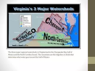
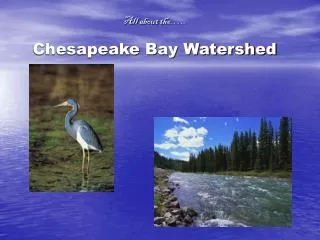
Modeling land cover change in the Chesapeake Bay watershed. SLEUTH: Progress, performance, interactions. Claire A. Jantz Shippensburg University Geography-Earth Science cajant@ship.edu. Scott J. Goetz Woods Hole Research Center sgoetz@whrc.org. SLEUTH Urban Growth Model.

E N D
Modeling land cover change in the Chesapeake Bay watershed SLEUTH: Progress, performance, interactions Claire A. Jantz Shippensburg University Geography-Earth Science cajant@ship.edu Scott J. Goetz Woods Hole Research Center sgoetz@whrc.org
SLEUTH Urban Growth Model • Urban / non-urban • Growth rules • Spontaneous (dispersion coefficient) • New spreading center (breed coefficient) • Edge (spread coefficient) • Road-influenced (road gravity coefficient) • Resistance to development • Slope (slope coefficient) • Excluded layer (user-defined)
SLEUTH Implementation • Calibration • Train the model to simulate historic patterns of development • Prediction • Forecast historic patterns of development into the future
Urban/non-urban 1990 accuracy >79% 2000 accuracy >83% Year 1990 (BLACK) Year 2000 (RED) Jantz, P.A., S. J. Goetz and C.A. Jantz (2005). Urbanization and the loss of resource lands in the Chesapeake Bay watershed. Environmental Management 36(6): 808-825.
Area developed: +4.5% Number of urban clusters: +0.4%
Delmarva Scenarios (Demo) • “Business as usual” • High growth, trend, slow growth • “Smart growth” • High growth, trend, slow growth • Principles of exclusion and attraction
Business as usual inputs • Initialize with 2000 extent of urbanization • Current protected land areas
“Smart growth” inputs • Initialize with 2000 extent of urbanization • Exclusion: Current protected land areas, plus… • Protection for large, intact forest patches • Protection for riparian and coastal zones and wetlands • Attraction: • In Maryland: Priority Funding Areas • In Delaware and Virginia: Urbanized areas
2030 Forecast, “Business as usual” TREND Fine scale (30 m development probability)
2030 Forecast, “Smart growth” TREND Fine scale (30 m development probability)
2030 Forecast, “Business as usual” TREND 7,290 m x 7,290 grid
2030 Forecast, “Smart growth” TREND 7,290 m x 7,290 grid
0 - 20 2030 Forecast, “Business as usual” TREND HUC 11 watershed scale
0 - 20 2030 Forecast, “Smart growth” TREND HUC 11 watershed scale
SG Boom SG Trend SG Bust BAU Boom BAU Trend BAU Bust
GAMe forecasts SLEUTH fine scale forecasts Agriculture forecasts Forest forecasts Interaction of models Exclusion Attraction
Thank you! Jantz, P.A., S. J. Goetz and C.A. Jantz (2005). Urbanization and the loss of resource lands in the Chesapeake Bay watershed. Environmental Management 36(6): 808-825. Jantz, C.A. and S.J. Goetz (2005). Analysis of scale dependencies in an urban land use change model. International Journal of Geographical Information Science 19 (2): 217-241. Goetz S. J., Jantz C. A., Prince S. D., Smith A. J., Wright R. and Varlyguin D. 2004. Integrated analysis of ecosystem interactions with land use change: the Chesapeake Bay watershed. In Ecosystems and Land Use Change, pp. 263-275. Eds. R. S. DeFries, G. P. Asner & R. A. Houghton. Geophysical Monograph Series, American Geophysical Union, Washington DC. Jantz, C.A., S.J. Goetz, and M. K. Shelley (2003). Using the SLEUTH urban growth model to simulate the impacts of future policy scenarios on urban land use in the Baltimore-Washington metropolitan area. Environment and Planning B 31 (2): 251-271. WHRC website, Land Use Change in the Chesapeake Bay Watershed: http://whrc.org/midatlantic/