Download
1 / 1
10 likes | 93 Vues
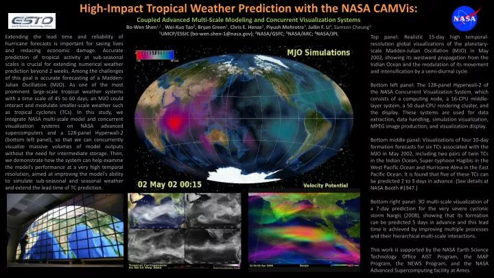
High-Impact Tropical Weather Prediction with the NASA CAMVis : Coupled Advanced Multi-Scale Modeling and Concurrent Visualization Systems Bo- Wen Shen 1,2 , Wei- Kuo Tao 2 , Bryan Green 3 , Chris E. Henze 3 , Piyush Mehrotra 3 , Juilin F. Li 4 , Samson Cheung 3

E N D
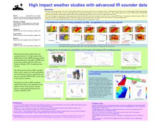
High-Impact Tropical Weather Prediction with the NASA CAMVis: Coupled Advanced Multi-Scale Modeling and Concurrent Visualization Systems Bo-Wen Shen1,2 , Wei-Kuo Tao2, Bryan Green3, Chris E. Henze3, Piyush Mehrotra3, Juilin F. Li4, Samson Cheung3 1UMCP/ESSIC (bo-wen.shen-1@nasa.gov); 2NASA/GSFC; 3NASA/ARC; 4NASA/JPL Extending the lead time and reliability of hurricane forecasts is important for saving lives and reducing economic damage. Accurate prediction of tropical activity at sub-seasonal scales is crucial for extending numerical weather prediction beyond 2 weeks. Among the challenges of this goal is accurate forecasting of a Madden-Julian Oscillation (MJO). As one of the most prominent large-scale tropical weather systems with a time scale of 45 to 60 days, an MJO could interact and modulate smaller-scale weather such as tropical cyclones (TCs). In this study, we integrate NASA multi-scale model and concurrent visualization systems on NASA advanced supercomputers and a 128-panel Hyperwall-2 (bottom left panel), so that we can concurrently visualize massive volumes of model outputs without the need for intermediate storage. Then, we demonstrate how the system can help examine the model's performance at a very high temporal resolution, aimed at improving the model's ability to simulate sub-seasonal and seasonal weather and extend the lead time of TC prediction. Top panel: Realistic 15-day high temporal-resolution global visualizations of the planetary-scale Madden-Julian Oscillation (MJO) in May 2002, showing its westward propagation from the Indian Ocean and the modulation of its movement and intensification by a semi-diurnal cycle. Bottom left panel: The 128-panel Hyperwall-2 of the NASA Concurrent Visualization System, which consists of a computing node, a 16-CPU middle-layer system, a 50 dual-CPU rendering cluster, and the display. These systems are used for data extraction, data handling, simulation visualization, MPEG image production, and visualization display. Bottom middle panel: Visualizations of four 10-day formation forecasts for six TCs associated with the MJO in May 2002, including two pairs of twin TCs in the Indian Ocean, Super-typhoon Hagibis in the West Pacific Ocean and Hurricane Alma in the East Pacific Ocean. It is found that five of these TCs can be predicted 2 to 3 days in advance. (See details at NASA Booth #1947.) Bottom right panel: 3D multi-scale visualization of a 7-day prediction for the very severe cyclonic storm Nargis (2008), showing that its formation can be predicted 5 days in advance and this lead time is achieved by improving multiple processes and their hierarchical multi-scale interactions. This work is supported by the NASA Earth Science Technology Office AIST Program, the MAP Program, the NEWS Program, and the NASA Advanced Supercomputing facility at Ames.