Download
1 / 1
10 likes | 110 Vues
High impact weather studies with advanced IR sounder data. Objectives

E N D
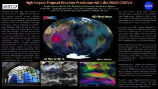
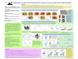
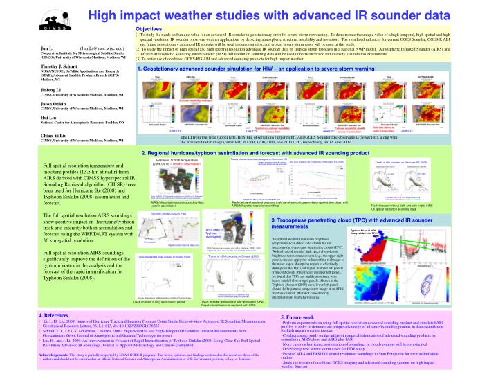
High impact weather studies with advanced IR sounder data • Objectives • To study the needs and unique value for an advanced IR sounder in geostationary orbit for severe storm nowcasting. To demonstrate the unique value of a high temporal, high spatial and high spectral resolution IR sounder on severe weather applications by depicting atmospheric structure, instability and inversion. The simulated radiances for current GOES Sounder, GOES-R ABI and future geostationary advanced IR sounder will be used in demonstration, and typical severe storm cases will be used in this study. • (2) To study the impact of high spatial and high spectral resolution advanced IR sounder data on tropical storm forecasts in a regional NWP model. Atmospheric InfraRed Sounder (AIRS) and Infrared Atmospheric Sounding Interferometer (IASI) full resolution sounding data will be used in hurricane track and intensity assimilation experiments. • (3) To better use of combined GOES-R/S ABI and advanced sounding products for high impact weather. Jun Li (Jun.Li@ssec.wisc.edu) Cooperative Institute for Meteorological Satellite Studies (CIMSS), University of Wisconsin-Madison, Madison, WI Timothy J. Schmit NOAA/NESDIS, SaTellite Applications and Research (STAR), Advanced Satellite Products Branch (ASPB) Madison, WI Jinlong Li CIMSS, University of Wisconsin-Madison, Madison, WI Jason Otikin CIMSS, University of Wisconsin-Madison, Madison, WI Hui Liu National Center for Atmospheric Research, Boulder, CO Chian-Yi Liu CIMSS, University of Wisconsin-Madison, Madison, WI 1. Geostationary advanced sounder simulation for HIW – an application to severe storm warning The LI from true field (upper left), HES-like observations (upper right), ABI/GOES Sounder like observations (lower left), along with the simulated radar image (lower left) at 1300, 1700, 1800, and 2100 UTC, respectively, on 12 June 2002. 2. Regional hurricane/typhoon assimilation and forecast with advanced IR sounding product Full spatial resolution temperature and moisture profiles (13.5 km at nadir) from AIRS derived with CIMSS hyperspectral IR Sounding Retrieval algorithm (CHISR) have been used for Hurricane Ike (2008) and Typhoon Sinlaku (2008) assimilation and forecast. The full spatial resolution AIRS soundings show positive impact on hurricane/typhoon track and intensity both in assimilation and forecast using the WRF/DART system with 36 km spatial resolution. Full spatial resolution AIRS soundings significantly improve the definition of the typhoon vortex in the analysis and the forecast of the rapid intensification for Typhoon Sinlaku (2008). Track (left) and sea level pressure (right) analysis during assimilation period (two days) with AIRS full spatial resolution soundings AIRS full spatial resolution sounding data used in assimilation Track forecast without (left) and with (right) AIRS full spatial resolution sounding data 3. Tropopause penetrating cloud (TPC) with advanced IR sounder measurements AIRS used in Typhoon assimilation Broadband method (minimum brightness temperature) can detect cold clouds but not necessary the tropopause penetrating clouds (TPC). With advanced sounder high spectral resolution brightness temperature spectra (e,g., the upper right panel), one can apply the online/offline technique to the water vapor absorption region to effectively distinguish the TPC (red region in upper left panel) from cold clouds (blue region in upper left panel), we found that TPCs are highly associated with heavy rainfall (lower right panel). Shown is the Typhoon Morakot (2009) case, lower left panel shows the brightness temperature image at an AIRS window channel. Morakot caused heavy precipitation in south Taiwan area. Track forecast without (left) and with (right) AIRS. Rapid intensification is captured with AIRS. Track analysis during assimilation period • 4. References • Li, J., H. Liu, 2009: Improved Hurricane Track and Intensity Forecast Using Single Field-of-View Advanced IR Sounding Measurements, Geophysical Research Letters, 36, L11813, doi:10.1029/2009GL038285. • Schmit, T. J., J. Li, S. Ackerman, J. Gurka, 2009: High-Spectral- and High-Temporal-Resolution Infrared Measurements from Geostationary Orbit, Journal of Atmospheric and Oceanic Technology (in press) • Liu, H., and J. Li, 2009: An Improvement in Forecast of Rapid Intensification of Typhoon Sinlaku (2008) Using Clear Sky Full Spatial Resolution Advanced IR Soundings, Journal of Applied Meteorology and Climate (submitted) • Acknowledgements:This study is partially supported by NOAA GOES-R program. The views, opinions, and findings contained in this report are those of the authors and should not be construed as an official National Oceanic and Atmospheric Administration or U.S. Government position, policy, or decision. • 5. Future work • Perform experiments on using full spatial resolution advanced sounding product and simulated ABI profiles in order to demonstrate unique advantage of advanced sounding product in data assimilation for high impact weather forecast • Conduct impact study on the utility of temporal information of advanced sounding products by assimilating AIRS alone and AIRS plus IASI • More cases on hurricane, assimilation of soundings in cloudy regions will be investigated • Developing new severe storm cases for HIW study • Provide AIRS and IASI full spatial resolution soundings to Stan Bemjamin for their assimilation studies • Study the impact of combined GOES imaging and advanced sounding systems on high impact weather forecast